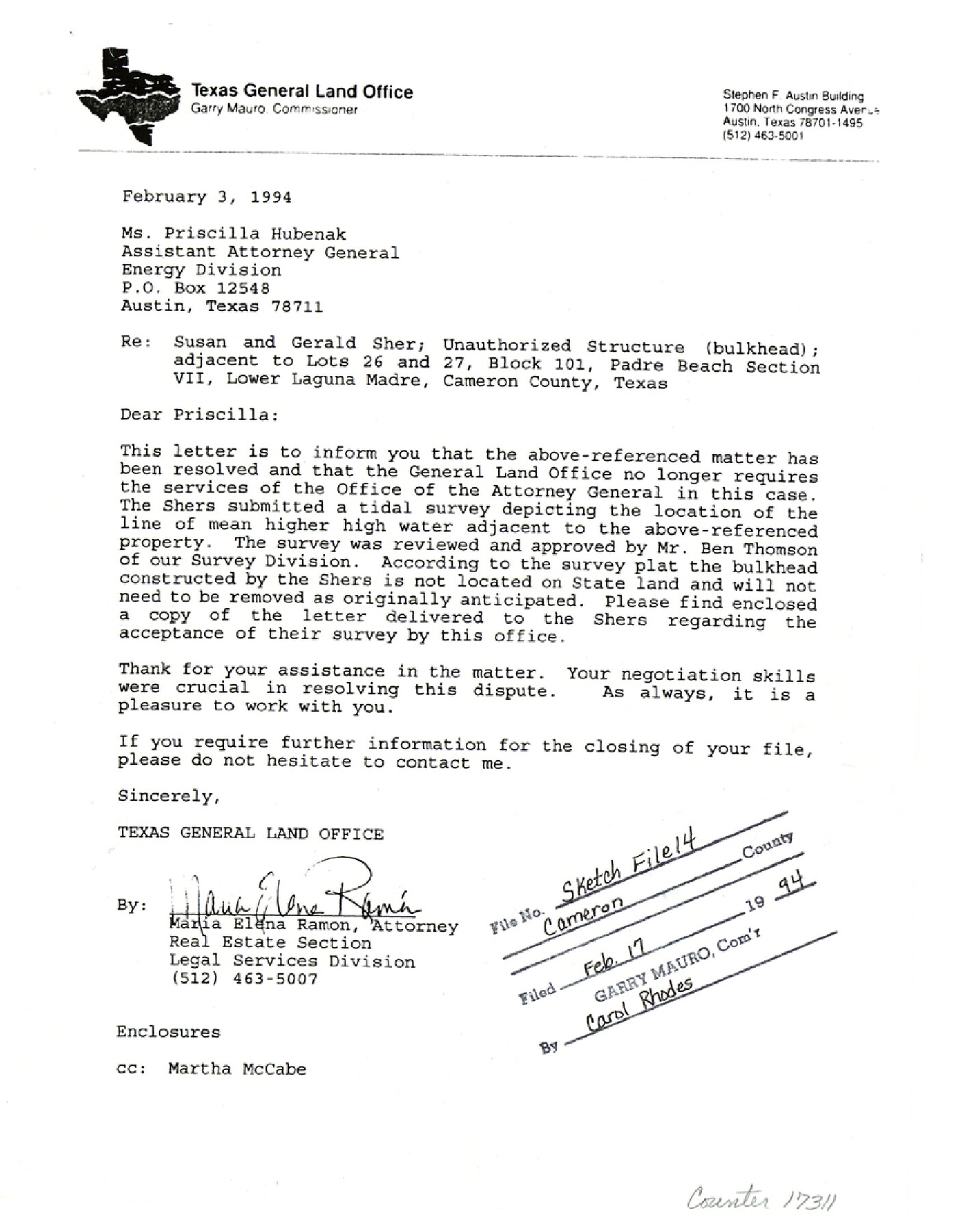
Cameron County Sketch File 14
[Map, correspondence, and surveyor's report relating to Lots 26 & 27, Block 101, Padre Beach Section VII, in the town of South Padre Island, Cameron County, Texas]
-
Map/Doc
17311
-
Collection
General Map Collection
-
Object Dates
1993 (Creation Date)
1994/2/17 (File Date)
-
People and Organizations
C.L. Fabian (Surveyor/Engineer)
-
Counties
Cameron
-
Subjects
Surveying Sketch File
-
Height x Width
11.2 x 8.8 inches
28.4 x 22.4 cm
-
Medium
multi-page, multi-format
-
Features
Lower Laguna Madre
Queen Isabela Fishing Pier
South Padre Island
Huisache Avenue
Part of: General Map Collection
Denton County Working Sketch 18

Print $20.00
- Digital $50.00
Denton County Working Sketch 18
1975
Size 24.1 x 38.8 inches
Map/Doc 68623
Anderson County Working Sketch 38

Print $20.00
- Digital $50.00
Anderson County Working Sketch 38
1985
Size 43.3 x 45.9 inches
Map/Doc 67038
Aransas County Rolled Sketch 25

Print $20.00
- Digital $50.00
Aransas County Rolled Sketch 25
1983
Size 18.4 x 24.5 inches
Map/Doc 5061
Young County Sketch File 19

Print $34.00
- Digital $50.00
Young County Sketch File 19
Size 14.5 x 8.9 inches
Map/Doc 40887
Nueces County NRC Article 33.136 Location Key Sheet

Print $20.00
- Digital $50.00
Nueces County NRC Article 33.136 Location Key Sheet
1975
Size 27.0 x 23.0 inches
Map/Doc 88588
Flight Mission No. BRA-7M, Frame 78, Jefferson County

Print $20.00
- Digital $50.00
Flight Mission No. BRA-7M, Frame 78, Jefferson County
1953
Size 16.0 x 16.1 inches
Map/Doc 85500
Aransas County Sketch File 5

Print $4.00
- Digital $50.00
Aransas County Sketch File 5
1850
Size 12.1 x 7.9 inches
Map/Doc 13108
Brazoria County Sketch File 12

Print $8.00
- Digital $50.00
Brazoria County Sketch File 12
1886
Size 12.8 x 8.2 inches
Map/Doc 14967
Kenedy County Rolled Sketch 8

Print $20.00
- Digital $50.00
Kenedy County Rolled Sketch 8
1915
Size 19.0 x 30.6 inches
Map/Doc 6468
Cass County Sketch File 2

Print $4.00
- Digital $50.00
Cass County Sketch File 2
1849
Size 12.4 x 7.7 inches
Map/Doc 17394
Kinney County Working Sketch 59

Print $20.00
- Digital $50.00
Kinney County Working Sketch 59
1999
Size 19.9 x 24.8 inches
Map/Doc 70241
Coast Chart No. 211 - Padre I. and Laguna Madre, Lat. 27° 12' to Lat. 26° 33', Texas

Print $20.00
- Digital $50.00
Coast Chart No. 211 - Padre I. and Laguna Madre, Lat. 27° 12' to Lat. 26° 33', Texas
1890
Size 30.5 x 24.1 inches
Map/Doc 73502
You may also like
Stonewall County Working Sketch 7

Print $20.00
- Digital $50.00
Stonewall County Working Sketch 7
1949
Size 30.7 x 24.5 inches
Map/Doc 62314
[Central Portion of McMullen County]
![91301, [Central Portion of McMullen County], Twichell Survey Records](https://historictexasmaps.com/wmedia_w700/maps/91301-1.tif.jpg)
Print $20.00
- Digital $50.00
[Central Portion of McMullen County]
1884
Size 28.8 x 25.7 inches
Map/Doc 91301
[Right of Way & Track Map, The Texas & Pacific Ry. Co. Main Line]
![64673, [Right of Way & Track Map, The Texas & Pacific Ry. Co. Main Line], General Map Collection](https://historictexasmaps.com/wmedia_w700/maps/64673.tif.jpg)
Print $20.00
- Digital $50.00
[Right of Way & Track Map, The Texas & Pacific Ry. Co. Main Line]
Size 11.2 x 18.6 inches
Map/Doc 64673
Anderson County Working Sketch 7

Print $20.00
- Digital $50.00
Anderson County Working Sketch 7
1920
Size 27.3 x 30.2 inches
Map/Doc 67006
Hidalgo County Rolled Sketch 9

Print $20.00
- Digital $50.00
Hidalgo County Rolled Sketch 9
1906
Size 18.9 x 24.8 inches
Map/Doc 6210
Orange County Working Sketch 11

Print $20.00
- Digital $50.00
Orange County Working Sketch 11
1922
Size 11.9 x 14.7 inches
Map/Doc 71343
Harris County Working Sketch 49

Print $20.00
- Digital $50.00
Harris County Working Sketch 49
1944
Size 28.7 x 33.9 inches
Map/Doc 65941
King County Sketch File 2

Print $4.00
- Digital $50.00
King County Sketch File 2
1882
Size 13.2 x 9.2 inches
Map/Doc 29020
Menard County Working Sketch 32

Print $20.00
- Digital $50.00
Menard County Working Sketch 32
1987
Size 35.8 x 33.8 inches
Map/Doc 70979
Van Zandt County Sketch File 20a

Print $4.00
- Digital $50.00
Van Zandt County Sketch File 20a
1858
Size 12.9 x 8.0 inches
Map/Doc 39428
Wichita County Working Sketch 10

Print $20.00
- Digital $50.00
Wichita County Working Sketch 10
1920
Size 25.4 x 16.1 inches
Map/Doc 72519
Potter County Sketch File 5

Print $20.00
- Digital $50.00
Potter County Sketch File 5
1890
Size 14.1 x 8.8 inches
Map/Doc 34387