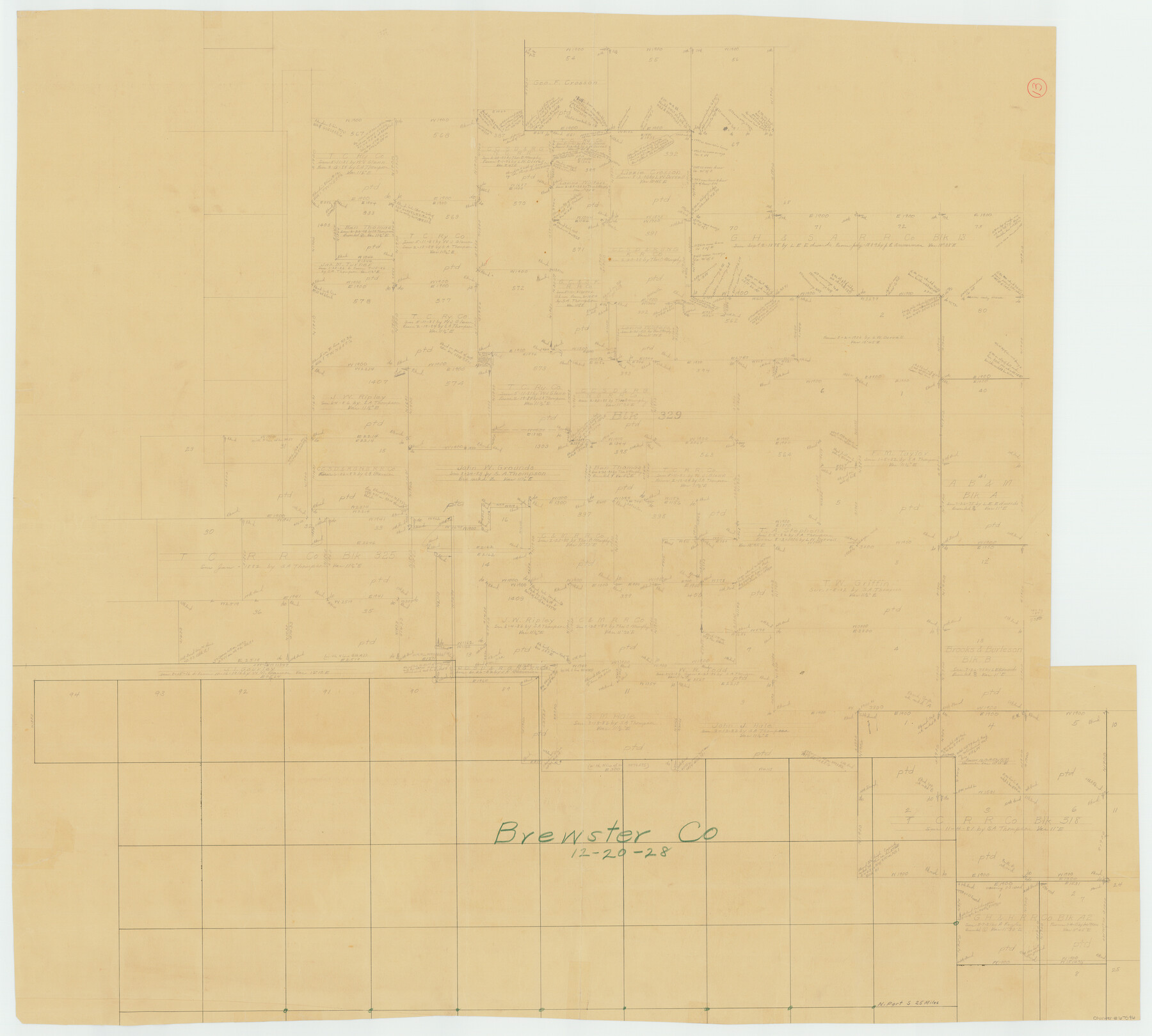
Brewster County Working Sketch 13
-
Map/Doc
67546
-
Collection
General Map Collection
-
Object Dates
12/20/1928 (Creation Date)
-
Counties
Brewster
-
Subjects
Surveying Working Sketch
-
Height x Width
39.5 x 43.9 inches
100.3 x 111.5 cm
Part of: General Map Collection
Travis County Rolled Sketch 32B

Print $20.00
- Digital $50.00
Travis County Rolled Sketch 32B
1948
Size 37.5 x 43.4 inches
Map/Doc 10310
Garza County Sketch File 5a

Print $20.00
- Digital $50.00
Garza County Sketch File 5a
1895
Size 20.7 x 38.2 inches
Map/Doc 10463
Nueces County Working Sketch 9

Print $20.00
- Digital $50.00
Nueces County Working Sketch 9
1977
Size 36.1 x 24.1 inches
Map/Doc 71311
Archer County

Print $20.00
- Digital $50.00
Archer County
1926
Size 43.7 x 37.9 inches
Map/Doc 95419
Harris County Working Sketch 9

Print $20.00
- Digital $50.00
Harris County Working Sketch 9
1908
Size 27.7 x 39.4 inches
Map/Doc 65901
Hutchinson County Rolled Sketch 4

Print $20.00
- Digital $50.00
Hutchinson County Rolled Sketch 4
Size 21.3 x 30.1 inches
Map/Doc 6277
Burnet County Working Sketch 12

Print $20.00
- Digital $50.00
Burnet County Working Sketch 12
1976
Size 17.3 x 19.9 inches
Map/Doc 67855
Flight Mission No. CRC-3R, Frame 199, Chambers County

Print $20.00
- Digital $50.00
Flight Mission No. CRC-3R, Frame 199, Chambers County
1956
Size 18.5 x 22.3 inches
Map/Doc 84854
District Map Showing Deaf Smith, Randall, Armstrong, Donley, Collingsworth, Castro, Swisher, Briscoe, Hall & Childress Counties, Texas

Print $40.00
- Digital $50.00
District Map Showing Deaf Smith, Randall, Armstrong, Donley, Collingsworth, Castro, Swisher, Briscoe, Hall & Childress Counties, Texas
1878
Size 42.9 x 82.3 inches
Map/Doc 1994
Howard County Boundary File 1

Print $51.00
- Digital $50.00
Howard County Boundary File 1
Size 14.4 x 8.8 inches
Map/Doc 55086
McMullen County Sketch File 3

Print $4.00
- Digital $50.00
McMullen County Sketch File 3
Size 8.2 x 6.5 inches
Map/Doc 31339
Map of Texas Coast from San Luis to Jupiter

Print $40.00
- Digital $50.00
Map of Texas Coast from San Luis to Jupiter
1852
Size 31.3 x 74.7 inches
Map/Doc 69975
You may also like
Howard County Rolled Sketch 11

Print $20.00
- Digital $50.00
Howard County Rolled Sketch 11
1940
Size 21.4 x 30.1 inches
Map/Doc 6242
Borden County Working Sketch 15

Print $20.00
- Digital $50.00
Borden County Working Sketch 15
1984
Size 25.5 x 18.9 inches
Map/Doc 67475
General Highway Map, Burnet County, Texas

Print $20.00
General Highway Map, Burnet County, Texas
1940
Size 18.6 x 25.2 inches
Map/Doc 79033
Calcasieu Pass to Sabine Pass

Print $20.00
- Digital $50.00
Calcasieu Pass to Sabine Pass
1946
Size 45.0 x 35.7 inches
Map/Doc 69807
Tyler County Sketch File 7

Print $4.00
- Digital $50.00
Tyler County Sketch File 7
1874
Size 13.4 x 7.7 inches
Map/Doc 38637
Hale County Sketch File 28

Print $4.00
- Digital $50.00
Hale County Sketch File 28
1892
Size 11.3 x 9.0 inches
Map/Doc 24776
[State Capitol Lands and various county School Land Leagues]
![90508, [State Capitol Lands and various county School Land Leagues], Twichell Survey Records](https://historictexasmaps.com/wmedia_w700/maps/90508-1.tif.jpg)
Print $2.00
- Digital $50.00
[State Capitol Lands and various county School Land Leagues]
1903
Size 8.3 x 10.1 inches
Map/Doc 90508

Preliminary Chart No. 31 of the Sea Coast of the United States from Galveston Bay to Matagorda Bay, Texas

Print $20.00
- Digital $50.00
Preliminary Chart No. 31 of the Sea Coast of the United States from Galveston Bay to Matagorda Bay, Texas
1857
Size 23.3 x 28.1 inches
Map/Doc 69950
Milam District

Print $20.00
- Digital $50.00
Milam District
1854
Size 30.2 x 18.9 inches
Map/Doc 3859
Plan B, Part 3rd Shewing that portion of the boundary between Texas and the United States, included between Logan's Ferry on the River Sabine and the intersection of the 32nd degree of N. Latitude with the western bank of the said river

Print $20.00
- Digital $50.00
Plan B, Part 3rd Shewing that portion of the boundary between Texas and the United States, included between Logan's Ferry on the River Sabine and the intersection of the 32nd degree of N. Latitude with the western bank of the said river
1842
Size 19.4 x 27.2 inches
Map/Doc 65411
Hutchinson County

Print $20.00
- Digital $50.00
Hutchinson County
1891
Size 19.7 x 24.5 inches
Map/Doc 91155