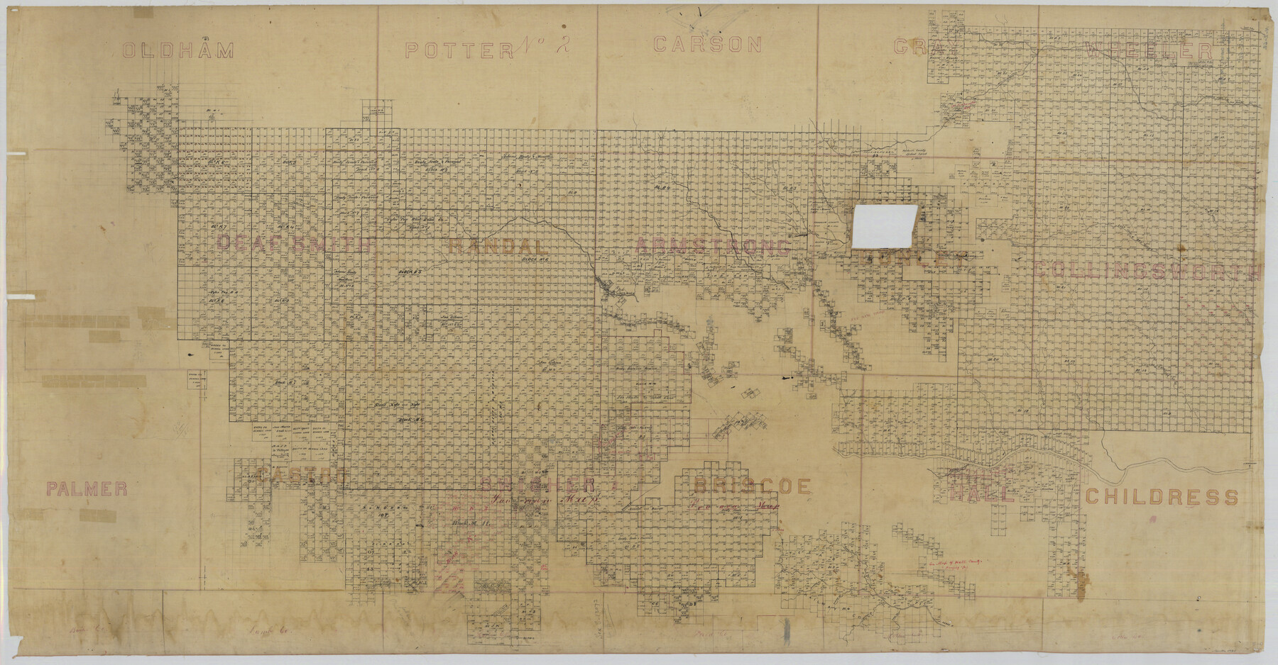
District Map Showing Deaf Smith, Randall, Armstrong, Donley, Collingsworth, Castro, Swisher, Briscoe, Hall & Childress Counties, Texas
Jack District Map Number 3
N-2-62
- 
                          Map/Doc
1994
 - 
                            Collection
General Map Collection
 - 
                            Object Dates
1878 (Creation Date)
 - 
                            People and Organizations
General Land Office (Publisher)
 - 
                            Counties
Deaf Smith Randall Armstrong Donley
 - 
                            Subjects
District
 - 
                            Height x Width
42.9 x 82.3 inches
109.0 x 209.0 cm
 - 
                            Comments
District map of what is now Deaf Smith, Randall, Armstrong, Donley, Collingsworth, Castro, Swisher, Briscoe, Hall, and Childress Counties.
 
Part of: General Map Collection
            Trinity County Sketch File 24


                                            Print $4.00                    
                                             -                         Digital $50.00                                    
                Trinity County Sketch File 24
Size 7.5 x 10.5 inches
                                Map/Doc 38556
            
            Flight Mission No. DQO-3K, Frame 78, Galveston County


                                            Print $20.00                    
                                             -                         Digital $50.00                                    
                Flight Mission No. DQO-3K, Frame 78, Galveston County
1952
Size 18.8 x 22.6 inches
                                Map/Doc 85083
            
            Flight Mission No. BQY-15M, Frame 13, Harris County


                                            Print $20.00                    
                                             -                         Digital $50.00                                    
                Flight Mission No. BQY-15M, Frame 13, Harris County
1953
Size 18.8 x 22.5 inches
                                Map/Doc 85311
            
            Goliad County Sketch File 42a


                                            Print $4.00                    
                                             -                         Digital $50.00                                    
                Goliad County Sketch File 42a
1845
Size 13.3 x 8.2 inches
                                Map/Doc 24353
            
            Bexar County Sketch File 40


                                            Print $4.00                    
                                             -                         Digital $50.00                                    
                Bexar County Sketch File 40
Size 8.4 x 7.0 inches
                                Map/Doc 14514
            
            Travis County Appraisal District Plat Map 2_2313


                                            Print $20.00                    
                                             -                         Digital $50.00                                    
                Travis County Appraisal District Plat Map 2_2313
Size 21.4 x 26.3 inches
                                Map/Doc 94215
            
            Pecos County Working Sketch 81


                                            Print $40.00                    
                                             -                         Digital $50.00                                    
                Pecos County Working Sketch 81
1961
Size 35.4 x 49.7 inches
                                Map/Doc 71553
            
            Stonewall County Rolled Sketch 27


                                            Print $20.00                    
                                             -                         Digital $50.00                                    
                Stonewall County Rolled Sketch 27
Size 31.0 x 44.2 inches
                                Map/Doc 9966
            
            Panola County Sketch File 12


                                            Print $2.00                    
                                             -                         Digital $50.00                                    
                Panola County Sketch File 12
Size 7.4 x 5.6 inches
                                Map/Doc 33469
            
            Fort Bend County Working Sketch 21


                                            Print $20.00                    
                                             -                         Digital $50.00                                    
                Fort Bend County Working Sketch 21
Size 26.9 x 28.6 inches
                                Map/Doc 69227
            
            Pecos County Sketch File 27B


                                            Print $20.00                    
                                             -                         Digital $50.00                                    
                Pecos County Sketch File 27B
1908
Size 25.7 x 20.8 inches
                                Map/Doc 12167
            
            El Paso County Rolled Sketch 2


                                            Print $40.00                    
                                             -                         Digital $50.00                                    
                El Paso County Rolled Sketch 2
Size 42.8 x 124.4 inches
                                Map/Doc 76433
            You may also like
            Battlefields of the Civil War


            Battlefields of the Civil War
1961
Size 25.8 x 19.7 inches
                                Map/Doc 92374
            
            [H. & T. C. RR. Company, Block 47, Sections 20- 28]


                                            Print $20.00                    
                                             -                         Digital $50.00                                    
                [H. & T. C. RR. Company, Block 47, Sections 20- 28]
Size 16.1 x 13.7 inches
                                Map/Doc 91249
            
            El Paso County Working Sketch 44


                                            Print $20.00                    
                                             -                         Digital $50.00                                    
                El Paso County Working Sketch 44
1992
Size 25.6 x 25.4 inches
                                Map/Doc 69066
            
            The Republic County of Montgomery. February 2, 1842


                                            Print $20.00                    
                                    
                The Republic County of Montgomery. February 2, 1842
2020
Size 19.9 x 21.7 inches
                                Map/Doc 96239
            
            Pecos County Rolled Sketch 82


                                            Print $20.00                    
                                             -                         Digital $50.00                                    
                Pecos County Rolled Sketch 82
1930
Size 28.4 x 25.7 inches
                                Map/Doc 10190
            
            Part of the boundary between the United States and Texas: north of Sabine River from the 72nd mile mound to Red River (C.2)


                                            Print $2.00                    
                                             -                         Digital $50.00                                    
                Part of the boundary between the United States and Texas: north of Sabine River from the 72nd mile mound to Red River (C.2)
1842
Size 12.8 x 8.3 inches
                                Map/Doc 65385
            
            Dimmit County Working Sketch 22


                                            Print $20.00                    
                                             -                         Digital $50.00                                    
                Dimmit County Working Sketch 22
1951
Size 37.3 x 38.7 inches
                                Map/Doc 68683
            
            Leon County Working Sketch 8


                                            Print $20.00                    
                                             -                         Digital $50.00                                    
                Leon County Working Sketch 8
1931
Size 28.9 x 42.8 inches
                                Map/Doc 70407
            
            [Sketch around O. A. Seward surveys]


                                            Print $20.00                    
                                             -                         Digital $50.00                                    
                [Sketch around O. A. Seward surveys]
Size 23.4 x 23.9 inches
                                Map/Doc 91991
            
            [Sketch of part of Blks. B5, 6, 2Z, M6, M8, M11 and M15]


                                            Print $40.00                    
                                             -                         Digital $50.00                                    
                [Sketch of part of Blks. B5, 6, 2Z, M6, M8, M11 and M15]
Size 18.6 x 62.0 inches
                                Map/Doc 89644
            
            Montgomery County Rolled Sketch 42


                                            Print $20.00                    
                                             -                         Digital $50.00                                    
                Montgomery County Rolled Sketch 42
1939
Size 13.9 x 20.2 inches
                                Map/Doc 6816