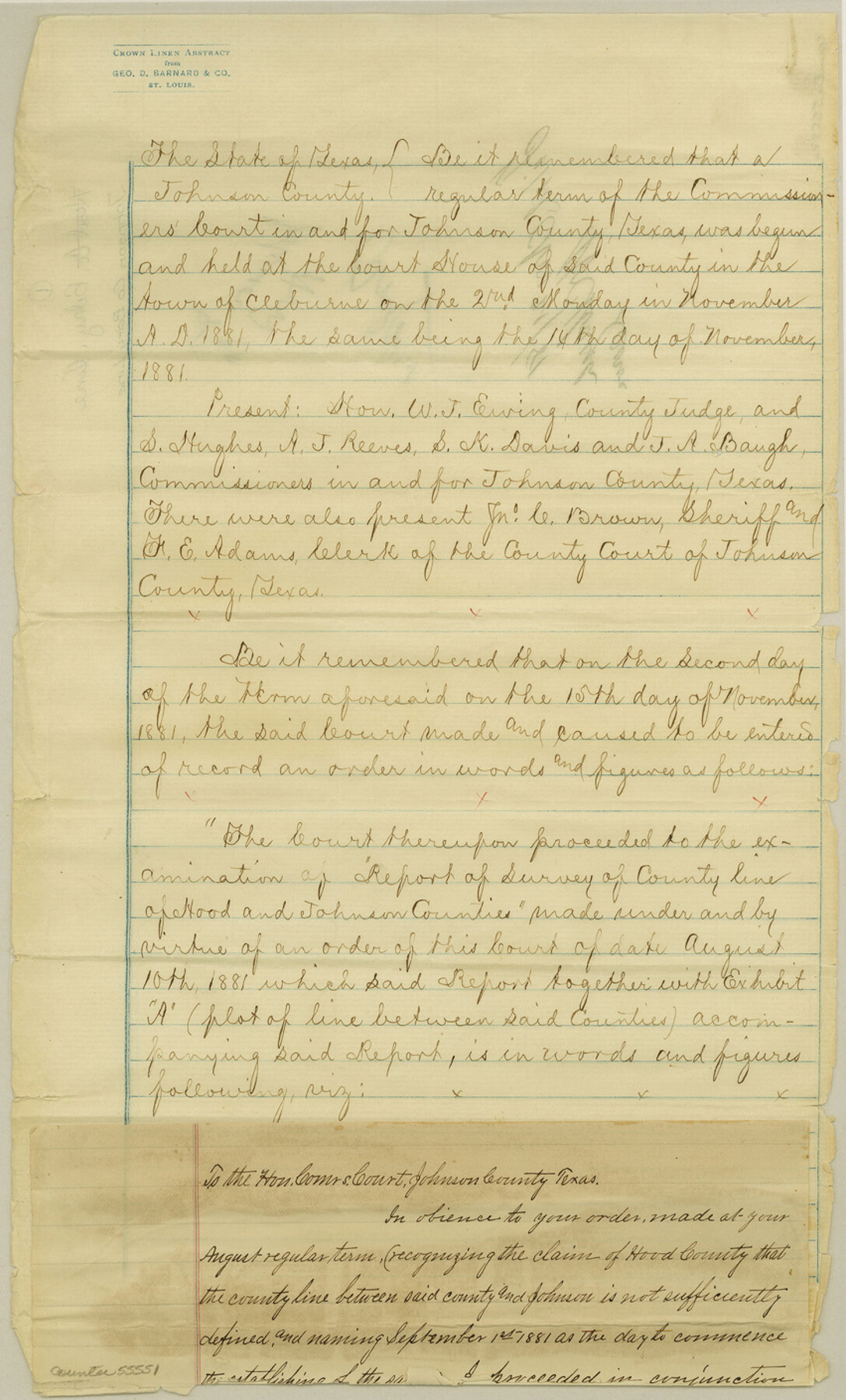
Johnson County Boundary File 1
[Surveyor's Report and Plat of Boundary line between Johnson and Hood Counties]
-
Map/Doc
55551
-
Collection
General Map Collection
-
Counties
Johnson
-
Subjects
County Boundaries
-
Height x Width
14.1 x 8.5 inches
35.8 x 21.6 cm
Part of: General Map Collection
Map of Espiritu Santo Bay in Calhoun County showing subdivision therof for mineral development

Print $20.00
- Digital $50.00
Map of Espiritu Santo Bay in Calhoun County showing subdivision therof for mineral development
1938
Size 38.6 x 42.9 inches
Map/Doc 2499
Val Verde County Sketch File 41

Print $20.00
- Digital $50.00
Val Verde County Sketch File 41
1938
Size 17.8 x 22.7 inches
Map/Doc 12583
Lubbock County Working Sketch 3

Print $20.00
- Digital $50.00
Lubbock County Working Sketch 3
1904
Size 13.9 x 20.5 inches
Map/Doc 70663
Fayette County Working Sketch 5

Print $20.00
- Digital $50.00
Fayette County Working Sketch 5
1981
Size 16.2 x 14.6 inches
Map/Doc 69169
Culberson County Sketch File 28

Print $4.00
- Digital $50.00
Culberson County Sketch File 28
1949
Size 14.5 x 9.0 inches
Map/Doc 20280
Wheeler County Working Sketch 7

Print $40.00
- Digital $50.00
Wheeler County Working Sketch 7
1972
Size 50.1 x 42.9 inches
Map/Doc 72496
Duval County Sketch File 19b

Print $6.00
- Digital $50.00
Duval County Sketch File 19b
Size 15.4 x 9.7 inches
Map/Doc 21320
Georgetown and the City of Washington the Capital of the United States of America

Print $20.00
- Digital $50.00
Georgetown and the City of Washington the Capital of the United States of America
1856
Size 15.7 x 18.7 inches
Map/Doc 95359
Polk County Working Sketch 39

Print $40.00
- Digital $50.00
Polk County Working Sketch 39
1978
Size 43.7 x 65.6 inches
Map/Doc 71656
Garza County Working Sketch 3

Print $20.00
- Digital $50.00
Garza County Working Sketch 3
1919
Size 13.8 x 14.0 inches
Map/Doc 63150
PSL Field Notes for Block JKL in Hudspeth County

PSL Field Notes for Block JKL in Hudspeth County
Map/Doc 81658
Mills County Working Sketch 21

Print $20.00
- Digital $50.00
Mills County Working Sketch 21
1981
Size 33.6 x 37.6 inches
Map/Doc 71051
You may also like
Flight Mission No. CRC-2R, Frame 186, Chambers County

Print $20.00
- Digital $50.00
Flight Mission No. CRC-2R, Frame 186, Chambers County
1956
Size 18.7 x 22.4 inches
Map/Doc 84764
Cass County Rolled Sketch OPD

Print $20.00
- Digital $50.00
Cass County Rolled Sketch OPD
1936
Size 29.6 x 26.1 inches
Map/Doc 5484
Harris County NRC Article 33.136 Sketch 4

Print $22.00
- Digital $50.00
Harris County NRC Article 33.136 Sketch 4
2001
Size 36.1 x 24.3 inches
Map/Doc 61600
Hutchinson County Rolled Sketch 44-17

Print $20.00
- Digital $50.00
Hutchinson County Rolled Sketch 44-17
2002
Size 24.0 x 36.0 inches
Map/Doc 77553
Baylor County Sketch File 27

Print $4.00
- Digital $50.00
Baylor County Sketch File 27
1895
Size 11.1 x 8.9 inches
Map/Doc 14226
Outer Continental Shelf Leasing Maps (Texas Offshore Operations)

Print $20.00
- Digital $50.00
Outer Continental Shelf Leasing Maps (Texas Offshore Operations)
Size 20.7 x 15.1 inches
Map/Doc 75848
Webb County Rolled Sketch 66

Print $20.00
- Digital $50.00
Webb County Rolled Sketch 66
1957
Size 31.9 x 21.8 inches
Map/Doc 8215
Jackson County Rolled Sketch 3C

Print $59.00
- Digital $50.00
Jackson County Rolled Sketch 3C
1913
Size 23.7 x 21.8 inches
Map/Doc 6339
Fractional Township No. 8 South Range No. 7 West of the Indian Meridian, Indian Territory

Print $20.00
- Digital $50.00
Fractional Township No. 8 South Range No. 7 West of the Indian Meridian, Indian Territory
1898
Size 19.2 x 24.3 inches
Map/Doc 75169
Marion County Boundary File 1

Print $14.00
- Digital $50.00
Marion County Boundary File 1
Size 12.9 x 8.2 inches
Map/Doc 56822
Kimble County Rolled Sketch 17 1/2

Print $59.00
- Digital $50.00
Kimble County Rolled Sketch 17 1/2
1889
Size 27.0 x 38.3 inches
Map/Doc 6510
Reeves County Working Sketch 64

Print $20.00
- Digital $50.00
Reeves County Working Sketch 64
1984
Size 26.3 x 26.5 inches
Map/Doc 63507