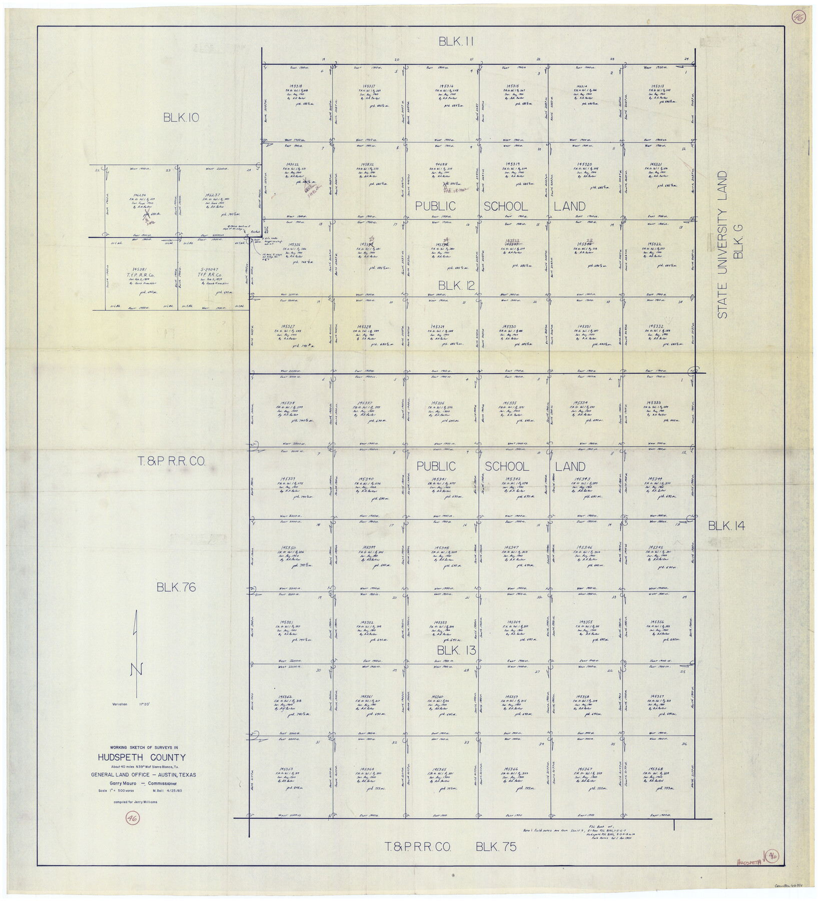
Hudspeth County Working Sketch 46
-
Map/Doc
66331
-
Collection
General Map Collection
-
Object Dates
4/25/1983 (Creation Date)
-
People and Organizations
M. Bell (Draftsman)
-
Counties
Hudspeth
-
Subjects
Surveying Working Sketch
-
Height x Width
47.0 x 43.0 inches
119.4 x 109.2 cm
-
Scale
1" = 500 varas
Part of: General Map Collection
Flight Mission No. DAG-24K, Frame 38, Matagorda County

Print $20.00
- Digital $50.00
Flight Mission No. DAG-24K, Frame 38, Matagorda County
1953
Size 18.5 x 15.8 inches
Map/Doc 86525
Liberty County Working Sketch 33

Print $20.00
- Digital $50.00
Liberty County Working Sketch 33
1954
Size 30.6 x 36.7 inches
Map/Doc 70492
Map of Hall County

Print $20.00
- Digital $50.00
Map of Hall County
1895
Size 25.2 x 20.2 inches
Map/Doc 3619
Karte des Staates, Texas

Print $20.00
- Digital $50.00
Karte des Staates, Texas
1851
Size 25.5 x 30.8 inches
Map/Doc 2123
Jackson County Working Sketch 7

Print $20.00
- Digital $50.00
Jackson County Working Sketch 7
1973
Size 35.7 x 27.1 inches
Map/Doc 66455
Flight Mission No. DAG-18K, Frame 182, Matagorda County

Print $20.00
- Digital $50.00
Flight Mission No. DAG-18K, Frame 182, Matagorda County
1952
Size 17.2 x 22.3 inches
Map/Doc 86374
Floyd County Boundary File 4a

Print $40.00
- Digital $50.00
Floyd County Boundary File 4a
Size 12.2 x 35.8 inches
Map/Doc 53496
Morris County Rolled Sketch 2A

Print $20.00
- Digital $50.00
Morris County Rolled Sketch 2A
Size 24.0 x 18.8 inches
Map/Doc 10246
Anderson County

Print $40.00
- Digital $50.00
Anderson County
1942
Size 54.2 x 47.3 inches
Map/Doc 66701
Lynn County Working Sketch 3

Print $20.00
- Digital $50.00
Lynn County Working Sketch 3
1953
Size 30.8 x 30.9 inches
Map/Doc 70673
Hudspeth County Rolled Sketch 74

Print $40.00
- Digital $50.00
Hudspeth County Rolled Sketch 74
1992
Size 49.5 x 38.1 inches
Map/Doc 9237

You may also like
Culberson County Rolled Sketch 19A
Print $20.00
- Digital $50.00
Culberson County Rolled Sketch 19A
Size 23.2 x 28.6 inches
Map/Doc 5652
Ellis County Sketch File 1

Print $6.00
- Digital $50.00
Ellis County Sketch File 1
1849
Size 6.5 x 7.9 inches
Map/Doc 21824
Tom Green County

Print $40.00
- Digital $50.00
Tom Green County
1942
Size 55.3 x 46.8 inches
Map/Doc 73304
[Sections 1-21, H. & G. N. Block 11]
![93116, [Sections 1-21, H. & G. N. Block 11], Twichell Survey Records](https://historictexasmaps.com/wmedia_w700/maps/93116-1.tif.jpg)
Print $20.00
- Digital $50.00
[Sections 1-21, H. & G. N. Block 11]
Size 31.3 x 42.8 inches
Map/Doc 93116
Parker County Working Sketch 14

Print $20.00
- Digital $50.00
Parker County Working Sketch 14
1980
Map/Doc 71464
Runnels County Working Sketch 21

Print $20.00
- Digital $50.00
Runnels County Working Sketch 21
1951
Size 43.6 x 37.0 inches
Map/Doc 63617
Property Line Map, Low Rent Housing Project Texas 18-1, Housing Authority of the City of Lubbock

Print $20.00
- Digital $50.00
Property Line Map, Low Rent Housing Project Texas 18-1, Housing Authority of the City of Lubbock
1941
Size 42.2 x 27.9 inches
Map/Doc 92753
Reeves County Working Sketch 25

Print $40.00
- Digital $50.00
Reeves County Working Sketch 25
1966
Size 31.4 x 59.0 inches
Map/Doc 63468
Dickens County

Print $20.00
- Digital $50.00
Dickens County
1895
Size 22.8 x 18.7 inches
Map/Doc 3484
Map showing eight tidal areas in Oso Bay and Oso Creek, Nueces County, Texas offered for Mineral Development

Print $20.00
- Digital $50.00
Map showing eight tidal areas in Oso Bay and Oso Creek, Nueces County, Texas offered for Mineral Development
1936
Size 17.9 x 29.7 inches
Map/Doc 2067
Culberson County Rolled Sketch 61

Print $20.00
- Digital $50.00
Culberson County Rolled Sketch 61
1985
Size 24.7 x 19.0 inches
Map/Doc 5677
Floyd County Boundary File 1

Print $30.00
- Digital $50.00
Floyd County Boundary File 1
Size 8.9 x 4.2 inches
Map/Doc 53445