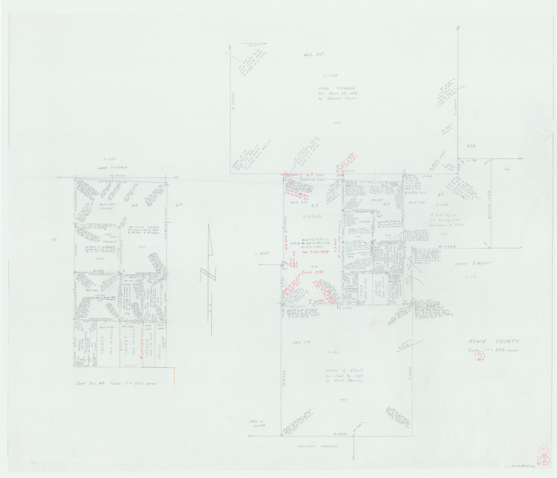
Bowie County Working Sketch 2
-
Map/Doc
67406
-
Collection
General Map Collection
-
Counties
Bowie
-
Subjects
Surveying Working Sketch
-
Height x Width
35.0 x 40.8 inches
88.9 x 103.6 cm
-
Scale
1" = 300 varas
-
Comments
Surveys located about 11 miles North 45 degrees West of Boston, Texas.
Part of: General Map Collection
San Saba County Rolled Sketch 2
Print $20.00
- Digital $50.00
San Saba County Rolled Sketch 2
Size 38.9 x 20.7 inches
Map/Doc 7743
Nueces County Rolled Sketch 65

Print $20.00
- Digital $50.00
Nueces County Rolled Sketch 65
1979
Size 19.5 x 26.2 inches
Map/Doc 6917
Flight Mission No. DQO-7K, Frame 75, Galveston County

Print $20.00
- Digital $50.00
Flight Mission No. DQO-7K, Frame 75, Galveston County
1952
Size 18.9 x 22.4 inches
Map/Doc 85102
Crosby County Sketch File 30

Print $4.00
- Digital $50.00
Crosby County Sketch File 30
1935
Size 11.4 x 7.4 inches
Map/Doc 20102
Runnels County Sketch File 6a

Print $4.00
Runnels County Sketch File 6a
1883
Size 12.9 x 8.2 inches
Map/Doc 35442
Orange County Working Sketch 39

Print $20.00
- Digital $50.00
Orange County Working Sketch 39
1966
Size 20.5 x 27.8 inches
Map/Doc 71371
Brazoria County Sketch File 33

Print $40.00
- Digital $50.00
Brazoria County Sketch File 33
Size 21.9 x 24.1 inches
Map/Doc 10957
Map of Comanche County

Print $40.00
- Digital $50.00
Map of Comanche County
1895
Size 47.5 x 50.0 inches
Map/Doc 4735
Brazos River, Jones Bridge Special Map Sheet

Print $4.00
- Digital $50.00
Brazos River, Jones Bridge Special Map Sheet
1936
Size 29.8 x 28.2 inches
Map/Doc 65280
Survey of The Rio Grande Roma to the Gulf of Mexico

Survey of The Rio Grande Roma to the Gulf of Mexico
Map/Doc 81739

Pecos County Rolled Sketch 146B

Print $20.00
- Digital $50.00
Pecos County Rolled Sketch 146B
Size 42.3 x 37.8 inches
Map/Doc 9742
You may also like
Jim Hogg County Sketch File 6a

Print $6.00
- Digital $50.00
Jim Hogg County Sketch File 6a
1939
Size 11.1 x 8.7 inches
Map/Doc 28408
The Republic County of Liberty. Spring 1842

Print $20.00
The Republic County of Liberty. Spring 1842
2020
Size 19.9 x 21.7 inches
Map/Doc 96212
Subdivision Plat of Blue Ridge State Farm Showing 18 Tracts

Print $20.00
- Digital $50.00
Subdivision Plat of Blue Ridge State Farm Showing 18 Tracts
Size 27.0 x 27.4 inches
Map/Doc 62978
Nueces County Rolled Sketch 92

Print $222.00
Nueces County Rolled Sketch 92
1983
Size 24.6 x 43.7 inches
Map/Doc 7028
Coast Chart No. 208 - Pass Cavallo, Lavaca and San Antonio Bays, Texas

Print $20.00
- Digital $50.00
Coast Chart No. 208 - Pass Cavallo, Lavaca and San Antonio Bays, Texas
1888
Size 43.9 x 35.7 inches
Map/Doc 73376
Flight Mission No. CRK-5P, Frame 163, Refugio County

Print $20.00
- Digital $50.00
Flight Mission No. CRK-5P, Frame 163, Refugio County
1956
Size 18.4 x 22.2 inches
Map/Doc 86944
Leon County Sketch File 14

Print $6.00
- Digital $50.00
Leon County Sketch File 14
Size 13.2 x 8.8 inches
Map/Doc 29767
Brooks County Rolled Sketch 20

Print $20.00
- Digital $50.00
Brooks County Rolled Sketch 20
1943
Size 27.0 x 26.4 inches
Map/Doc 5342
Map Defining Three Positions for North Line of Wilson Strickland

Print $20.00
- Digital $50.00
Map Defining Three Positions for North Line of Wilson Strickland
Size 25.5 x 10.7 inches
Map/Doc 91284
Harris County Historic Topographic 29

Print $20.00
- Digital $50.00
Harris County Historic Topographic 29
1915
Size 29.1 x 23.0 inches
Map/Doc 65840
Terrell County Working Sketch 18a

Print $40.00
- Digital $50.00
Terrell County Working Sketch 18a
1931
Size 48.9 x 34.6 inches
Map/Doc 62168
Brewster County Sketch File N-3c

Print $4.00
- Digital $50.00
Brewster County Sketch File N-3c
Size 12.7 x 8.4 inches
Map/Doc 15594