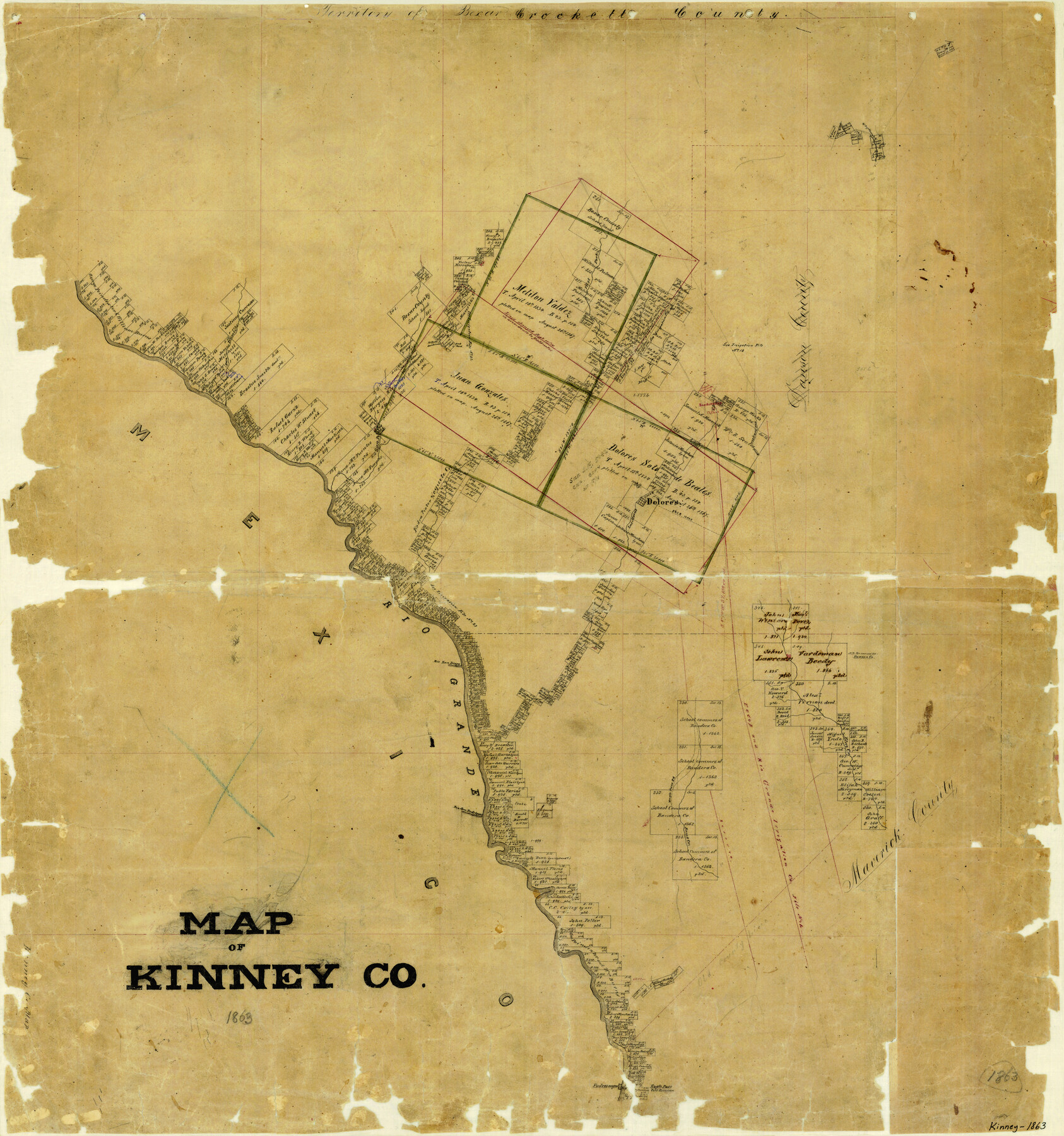
Map of Kinney County
-
Map/Doc
3774
-
Collection
General Map Collection
-
Object Dates
1863 (Creation Date)
-
Counties
Kinney
-
Subjects
County
-
Height x Width
31.4 x 29.7 inches
79.8 x 75.4 cm
-
Features
Piedra Pinta Creek
Stampede Creek
East Fork [of Piedra Pinto Creek]
Devil's River
Fort Duncan
Eagle Pass
Piedras Negras
Saus Creek
Eagle Pass Road
Rio San Rodriguez
Elm Creek
Rio San Diego
Rio Grande
San Pedro Creek
Zoquete Creek
West Prong of Nueces River
West Fork of Elm Creek
Dolores
Las Moras Creek
Fort Clark
Brackettsville [sic]
Bluff Creek
San Felipe Creek
San Antonio Road
El Paso Road
El Paso and San Antonio Road
Maverick's Creek
West Fork [of Xoquete Creek]
West Fork [of Piedra Pinta Creek]
Part of: General Map Collection
Travis County Sketch File 18

Print $20.00
- Digital $50.00
Travis County Sketch File 18
1872
Size 24.2 x 25.4 inches
Map/Doc 12458
Flight Mission No. DCL-7C, Frame 22, Kenedy County

Print $20.00
- Digital $50.00
Flight Mission No. DCL-7C, Frame 22, Kenedy County
1943
Size 15.4 x 15.2 inches
Map/Doc 86014
Haskell County Sketch File 6

Print $22.00
- Digital $50.00
Haskell County Sketch File 6
1858
Size 7.7 x 12.2 inches
Map/Doc 26126
Dallas County Sketch File 10

Print $4.00
- Digital $50.00
Dallas County Sketch File 10
1858
Size 12.5 x 8.2 inches
Map/Doc 20414

Nueces County Rolled Sketch 75

Print $40.00
- Digital $50.00
Nueces County Rolled Sketch 75
1945
Size 56.0 x 24.0 inches
Map/Doc 9618
Flight Mission No. DQN-1K, Frame 123, Calhoun County

Print $20.00
- Digital $50.00
Flight Mission No. DQN-1K, Frame 123, Calhoun County
1953
Size 18.4 x 22.2 inches
Map/Doc 84189


PSL Field Notes for Blocks B13, B18, and B28 in Crane and Ward Counties, and Blocks B19, B20, and B29 in Ward County

PSL Field Notes for Blocks B13, B18, and B28 in Crane and Ward Counties, and Blocks B19, B20, and B29 in Ward County
Map/Doc 81647
Sherman County

Print $20.00
- Digital $50.00
Sherman County
1932
Size 39.6 x 36.4 inches
Map/Doc 77422
St. L. S-W. Ry. of Texas Map of Lufkin Branch in Cherokee County Texas

Print $40.00
- Digital $50.00
St. L. S-W. Ry. of Texas Map of Lufkin Branch in Cherokee County Texas
1912
Size 23.4 x 121.6 inches
Map/Doc 64016
You may also like
Flight Mission No. CRC-2R, Frame 190, Chambers County

Print $20.00
- Digital $50.00
Flight Mission No. CRC-2R, Frame 190, Chambers County
1956
Size 18.8 x 22.4 inches
Map/Doc 84768
Jones County Working Sketch 8

Print $20.00
- Digital $50.00
Jones County Working Sketch 8
1979
Size 25.3 x 20.9 inches
Map/Doc 66646
Houston County Sketch File 28

Print $20.00
- Digital $50.00
Houston County Sketch File 28
1877
Size 21.8 x 21.3 inches
Map/Doc 11789
Terrell County Working Sketch 19

Print $20.00
- Digital $50.00
Terrell County Working Sketch 19
1932
Size 18.8 x 25.7 inches
Map/Doc 62169
Map of the Houston and Great Northern R.R. from Trinity River to Palestine

Print $40.00
- Digital $50.00
Map of the Houston and Great Northern R.R. from Trinity River to Palestine
1872
Size 30.3 x 119.9 inches
Map/Doc 64549
Padre Island National Seashore

Print $4.00
- Digital $50.00
Padre Island National Seashore
Size 16.2 x 22.1 inches
Map/Doc 60534
Nueces County Sketch File 30

Print $3.00
- Digital $50.00
Nueces County Sketch File 30
1907
Size 11.4 x 11.9 inches
Map/Doc 32600
Trinity County Sketch File 1

Print $4.00
- Digital $50.00
Trinity County Sketch File 1
1855
Size 8.3 x 8.2 inches
Map/Doc 38488
Coleman County Sketch File 3

Print $4.00
- Digital $50.00
Coleman County Sketch File 3
1857
Size 9.5 x 8.1 inches
Map/Doc 18670
Cherokee County Working Sketch 18

Print $40.00
- Digital $50.00
Cherokee County Working Sketch 18
1958
Size 74.6 x 43.6 inches
Map/Doc 67973
Flight Mission No. DIX-10P, Frame 143, Aransas County

Print $20.00
- Digital $50.00
Flight Mission No. DIX-10P, Frame 143, Aransas County
1956
Size 18.8 x 22.5 inches
Map/Doc 83945
Maverick County Working Sketch 20

Print $20.00
- Digital $50.00
Maverick County Working Sketch 20
1977
Size 26.1 x 22.0 inches
Map/Doc 70912