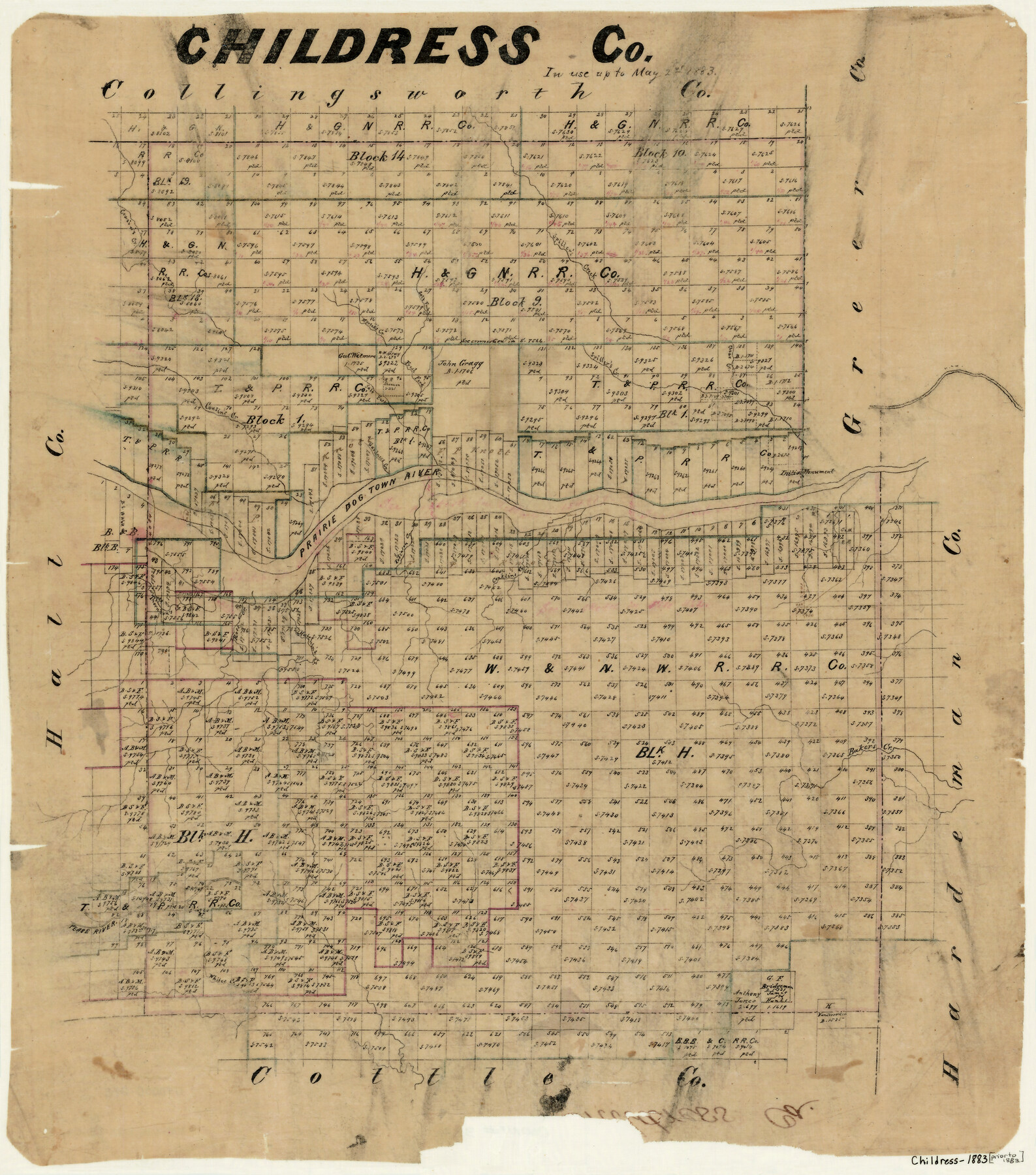
Childress County
-
Map/Doc
3394
-
Collection
General Map Collection
-
Object Dates
1883 (Creation Date)
-
Counties
Childress
-
Subjects
County
-
Height x Width
20.8 x 19.0 inches
52.8 x 48.3 cm
-
Comments
Note on map: "In use up to May 2, 1883".
-
Features
Conklin's Creek
Whites Creek
Pease River
Bakers Creek
Hutchins' Creek
Ross Creek
Thornton's Creek
Prairie Dog Town River
Robinson Creek
Cousin's Creek
Initial Monument
Gardners Creek
Myrick's Creek
Salt Fork of Myrick's Creek
Fresh Fork [of Myrick's Creek]
Clear Creek
Spiller's Creek
Part of: General Map Collection
Presidio County Working Sketch 29a

Print $20.00
- Digital $50.00
Presidio County Working Sketch 29a
1946
Size 38.9 x 31.6 inches
Map/Doc 71706
Edwards County Rolled Sketch J

Print $83.00
- Digital $50.00
Edwards County Rolled Sketch J
1918
Size 23.6 x 30.3 inches
Map/Doc 5818
Flight Mission No. DIX-8P, Frame 88, Aransas County

Print $20.00
- Digital $50.00
Flight Mission No. DIX-8P, Frame 88, Aransas County
1956
Size 18.6 x 22.3 inches
Map/Doc 83913
Refugio County Boundary File 2

Print $32.00
- Digital $50.00
Refugio County Boundary File 2
Size 14.1 x 8.8 inches
Map/Doc 58233
Right of Way and Track Map Texas & New Orleans R.R. Co. operated by the T. & N. O. R.R. Co. Dallas-Sabine Branch

Print $40.00
- Digital $50.00
Right of Way and Track Map Texas & New Orleans R.R. Co. operated by the T. & N. O. R.R. Co. Dallas-Sabine Branch
1918
Size 26.1 x 56.7 inches
Map/Doc 64150
Culberson County Working Sketch 12

Print $20.00
- Digital $50.00
Culberson County Working Sketch 12
1922
Size 20.9 x 17.8 inches
Map/Doc 68464
Edwards County Working Sketch 60

Print $20.00
- Digital $50.00
Edwards County Working Sketch 60
1954
Size 20.5 x 43.7 inches
Map/Doc 68936
Swisher County Sketch File 2a

Print $96.00
- Digital $50.00
Swisher County Sketch File 2a
1891
Size 14.3 x 8.7 inches
Map/Doc 37578
Chambers County Working Sketch 2

Print $20.00
- Digital $50.00
Chambers County Working Sketch 2
1904
Size 34.6 x 25.3 inches
Map/Doc 67985
Victoria County Aerial Photograph Index Sheet 4

Print $20.00
- Digital $50.00
Victoria County Aerial Photograph Index Sheet 4
1953
Size 19.8 x 23.4 inches
Map/Doc 83748
Flight Mission No. DAG-21K, Frame 101, Matagorda County

Print $20.00
- Digital $50.00
Flight Mission No. DAG-21K, Frame 101, Matagorda County
1952
Size 18.6 x 22.4 inches
Map/Doc 86430
Flight Mission No. CRC-4R, Frame 63, Chambers County

Print $20.00
- Digital $50.00
Flight Mission No. CRC-4R, Frame 63, Chambers County
1956
Size 18.7 x 22.4 inches
Map/Doc 84867
You may also like
Corpus Christi Harbor

Print $40.00
- Digital $50.00
Corpus Christi Harbor
1972
Size 36.9 x 52.3 inches
Map/Doc 73477
Brazos River, Ball Hill Sheet/Big Creek

Print $6.00
- Digital $50.00
Brazos River, Ball Hill Sheet/Big Creek
1926
Size 34.3 x 30.0 inches
Map/Doc 65281
League 206 Ochiltree County School Land

Print $20.00
- Digital $50.00
League 206 Ochiltree County School Land
Size 24.0 x 19.5 inches
Map/Doc 92481
Motley County Sketch File 2 (S)

Print $20.00
- Digital $50.00
Motley County Sketch File 2 (S)
Size 31.1 x 25.1 inches
Map/Doc 42133
Kinney County Sketch File 15

Print $20.00
- Digital $50.00
Kinney County Sketch File 15
1887
Size 13.0 x 19.0 inches
Map/Doc 11940
Flight Mission No. DAH-17M, Frame 28, Orange County

Print $20.00
- Digital $50.00
Flight Mission No. DAH-17M, Frame 28, Orange County
1953
Size 18.5 x 22.3 inches
Map/Doc 86891
United States - Gulf Coast Texas - Southern part of Laguna Madre

Print $20.00
- Digital $50.00
United States - Gulf Coast Texas - Southern part of Laguna Madre
1941
Size 26.7 x 18.5 inches
Map/Doc 72942
Nacogdoches County Working Sketch 12

Print $20.00
- Digital $50.00
Nacogdoches County Working Sketch 12
1997
Size 44.9 x 34.9 inches
Map/Doc 71228
Victoria County

Print $20.00
- Digital $50.00
Victoria County
1858
Size 26.5 x 29.2 inches
Map/Doc 4115
Foard County Sketch File 38

Print $11.00
- Digital $50.00
Foard County Sketch File 38
1890
Size 11.1 x 7.2 inches
Map/Doc 22871
Bexar County Working Sketch 23

Print $20.00
- Digital $50.00
Bexar County Working Sketch 23
1987
Size 27.7 x 34.3 inches
Map/Doc 67339
Kleberg County Rolled Sketch 10-1

Print $20.00
- Digital $50.00
Kleberg County Rolled Sketch 10-1
1951
Size 36.9 x 32.2 inches
Map/Doc 9383