Randall County Sketch File 3
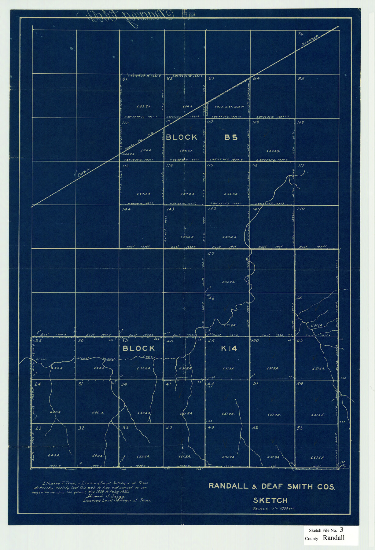
[Sketch of surveys in Block B5 and Block K14 in Randall and Deaf Smith Counties]
-
Map/Doc
12206
-
Collection
General Map Collection
-
Object Dates
1930 (Creation Date)
4/11/1930 (File Date)
11/1929 - 2/1930 (Survey Date)
-
People and Organizations
Howard T. Trigg (Surveyor/Engineer)
-
Counties
Randall Deaf Smith
-
Subjects
Surveying Sketch File
-
Height x Width
23.8 x 16.3 inches
60.5 x 41.4 cm
-
Medium
blueprint/diazo
-
Scale
1" = 1000 varas
-
Features
AT&SF
Tierra Blanca Creek
Part of: General Map Collection
Reeves County Working Sketch 64

Print $20.00
- Digital $50.00
Reeves County Working Sketch 64
1984
Size 26.3 x 26.5 inches
Map/Doc 63507
Galveston County NRC Article 33.136 Sketch 66

Print $42.00
- Digital $50.00
Galveston County NRC Article 33.136 Sketch 66
2012
Size 23.0 x 34.8 inches
Map/Doc 95000
Potter County Rolled Sketch 12

Print $20.00
- Digital $50.00
Potter County Rolled Sketch 12
2004
Size 18.8 x 24.7 inches
Map/Doc 82480
Township No. 2 South Range No. 19 West of the Indian Meridian

Print $20.00
- Digital $50.00
Township No. 2 South Range No. 19 West of the Indian Meridian
1875
Size 19.2 x 24.8 inches
Map/Doc 75181
Harris County Rolled Sketch HI

Print $20.00
- Digital $50.00
Harris County Rolled Sketch HI
1922
Size 30.9 x 42.0 inches
Map/Doc 9117
San Patricio County Sketch File 24

Print $10.00
San Patricio County Sketch File 24
1918
Size 10.0 x 4.3 inches
Map/Doc 36078
Lee County Working Sketch 22

Print $20.00
- Digital $50.00
Lee County Working Sketch 22
2010
Size 29.2 x 29.6 inches
Map/Doc 89271
Hutchinson County Working Sketch 8

Print $20.00
- Digital $50.00
Hutchinson County Working Sketch 8
1919
Size 24.8 x 16.7 inches
Map/Doc 66366
Lampasas County Rolled Sketch 4

Print $20.00
- Digital $50.00
Lampasas County Rolled Sketch 4
2001
Size 27.1 x 38.5 inches
Map/Doc 6566
Webb County Sketch File 12a

Print $20.00
- Digital $50.00
Webb County Sketch File 12a
1886
Size 20.7 x 31.4 inches
Map/Doc 12628
Liberty County Working Sketch 61

Print $20.00
- Digital $50.00
Liberty County Working Sketch 61
1969
Size 43.3 x 32.0 inches
Map/Doc 70521
Mitchell County

Print $20.00
- Digital $50.00
Mitchell County
1922
Size 42.6 x 38.3 inches
Map/Doc 2309
You may also like
Kendall County Working Sketch 21

Print $20.00
- Digital $50.00
Kendall County Working Sketch 21
1970
Size 44.7 x 23.8 inches
Map/Doc 66693
Austin County Sketch File 6b

Print $50.00
- Digital $50.00
Austin County Sketch File 6b
1894
Size 11.3 x 8.6 inches
Map/Doc 13872
Flight Mission No. DAG-23K, Frame 13, Matagorda County

Print $20.00
- Digital $50.00
Flight Mission No. DAG-23K, Frame 13, Matagorda County
1953
Size 18.5 x 22.2 inches
Map/Doc 86475
Map showing the John B. Pier Survey, Near Houston

Print $3.00
- Digital $50.00
Map showing the John B. Pier Survey, Near Houston
Size 11.9 x 17.8 inches
Map/Doc 478
Dawson County Rolled Sketch 9

Print $20.00
- Digital $50.00
Dawson County Rolled Sketch 9
1953
Size 36.6 x 45.7 inches
Map/Doc 8773
Freestone County Working Sketch 14

Print $20.00
- Digital $50.00
Freestone County Working Sketch 14
1980
Size 37.4 x 38.9 inches
Map/Doc 69256
Map of Houston & Overton Branch Railroad

Print $40.00
- Digital $50.00
Map of Houston & Overton Branch Railroad
1877
Size 22.3 x 110.1 inches
Map/Doc 64460
Coryell County Rolled Sketch 2

Print $20.00
- Digital $50.00
Coryell County Rolled Sketch 2
1951
Size 15.7 x 19.1 inches
Map/Doc 5566
Zapata County

Print $40.00
- Digital $50.00
Zapata County
1901
Size 53.1 x 38.0 inches
Map/Doc 63143
Reeves County Rolled Sketch 16

Print $20.00
- Digital $50.00
Reeves County Rolled Sketch 16
1963
Size 22.3 x 27.3 inches
Map/Doc 7485
Floyd County Sketch File 7

Print $4.00
- Digital $50.00
Floyd County Sketch File 7
Size 8.9 x 14.3 inches
Map/Doc 22697
Hale County Rolled Sketch 9

Print $20.00
- Digital $50.00
Hale County Rolled Sketch 9
Size 25.1 x 17.6 inches
Map/Doc 6047