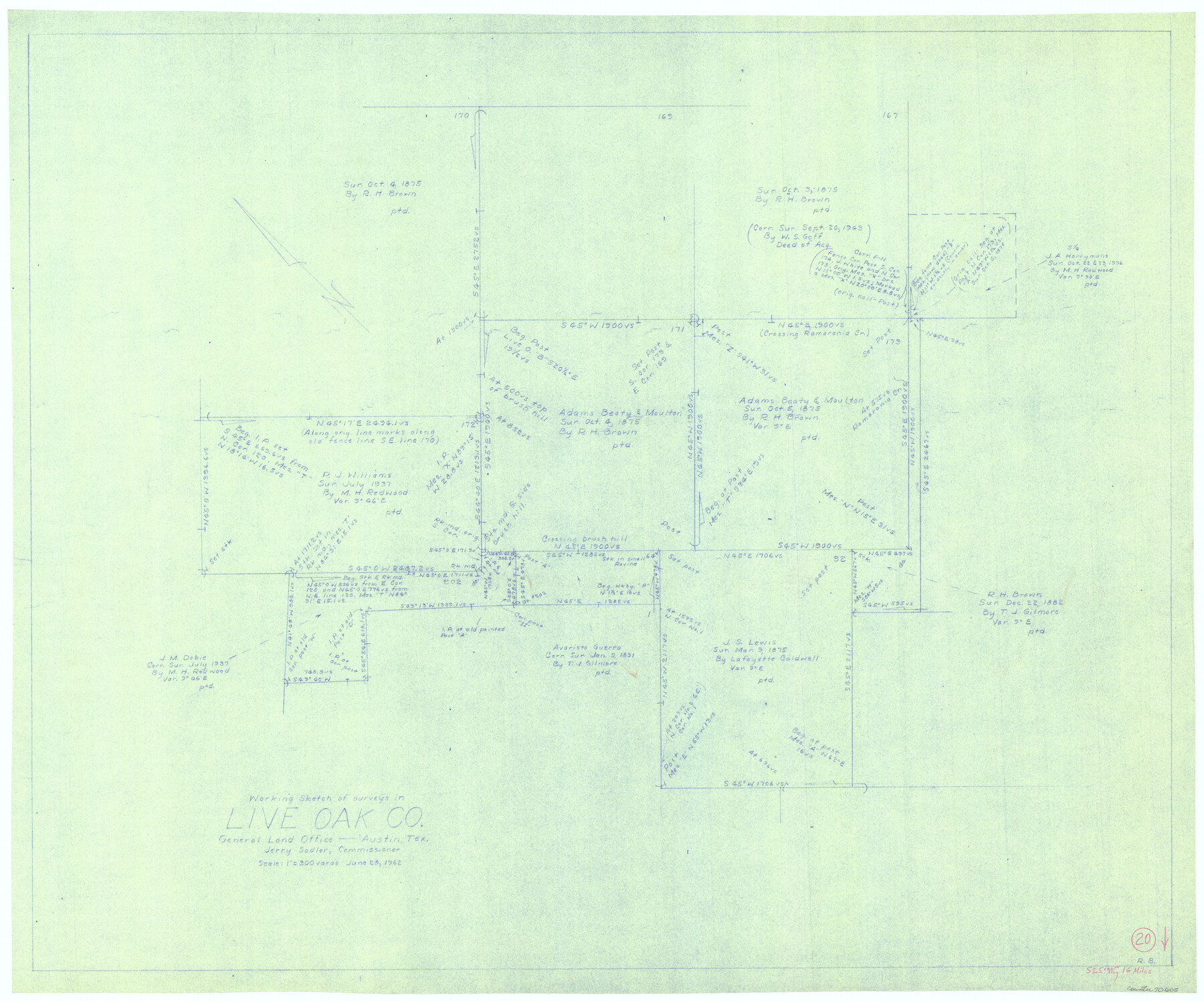
Live Oak County Working Sketch 20
-
Map/Doc
70605
-
Collection
General Map Collection
-
Object Dates
6/28/1962 (Creation Date)
-
People and Organizations
Roy Buckholts (Draftsman)
-
Counties
Live Oak
-
Subjects
Surveying Working Sketch
-
Height x Width
29.7 x 35.7 inches
75.4 x 90.7 cm
-
Scale
1" = 300 varas
Part of: General Map Collection
Culberson County Rolled Sketch 62

Print $20.00
- Digital $50.00
Culberson County Rolled Sketch 62
1985
Size 20.8 x 20.5 inches
Map/Doc 5678
Tarrant County Sketch File 16a

Print $10.00
- Digital $50.00
Tarrant County Sketch File 16a
1859
Size 8.4 x 8.2 inches
Map/Doc 37712
Fannin County Sketch File 2

Print $4.00
- Digital $50.00
Fannin County Sketch File 2
1853
Size 12.4 x 7.9 inches
Map/Doc 22445
Flight Mission No. DAG-23K, Frame 166, Matagorda County

Print $20.00
- Digital $50.00
Flight Mission No. DAG-23K, Frame 166, Matagorda County
1953
Size 15.9 x 19.1 inches
Map/Doc 86504
Crane County Rolled Sketch 14

Print $46.00
- Digital $50.00
Crane County Rolled Sketch 14
1935
Size 37.1 x 31.6 inches
Map/Doc 8680
Hutchinson County Sketch File 4a

Print $7.00
- Digital $50.00
Hutchinson County Sketch File 4a
Size 25.9 x 43.8 inches
Map/Doc 10625
Val Verde County Rolled Sketch 81

Print $20.00
- Digital $50.00
Val Verde County Rolled Sketch 81
Size 35.0 x 44.7 inches
Map/Doc 10088
Morris County Rolled Sketch 2A

Print $20.00
- Digital $50.00
Morris County Rolled Sketch 2A
Size 24.3 x 18.7 inches
Map/Doc 10675
Jefferson County Sketch File X

Print $42.00
- Digital $50.00
Jefferson County Sketch File X
Size 17.1 x 13.3 inches
Map/Doc 28087
[Surveys on the Trinity River]
![342, [Surveys on the Trinity River], General Map Collection](https://historictexasmaps.com/wmedia_w700/maps/342.tif.jpg)
Print $2.00
- Digital $50.00
[Surveys on the Trinity River]
Size 6.6 x 4.6 inches
Map/Doc 342
Sutton County Rolled Sketch 49

Print $20.00
- Digital $50.00
Sutton County Rolled Sketch 49
1947
Size 19.2 x 19.3 inches
Map/Doc 7890
Current Miscellaneous File 42

Print $4.00
- Digital $50.00
Current Miscellaneous File 42
Size 11.2 x 8.7 inches
Map/Doc 73981
You may also like
Nueces County Rolled Sketch 64

Print $55.00
Nueces County Rolled Sketch 64
1979
Size 25.3 x 38.0 inches
Map/Doc 6911
Van Zandt County Sketch File 40

Print $4.00
- Digital $50.00
Van Zandt County Sketch File 40
Size 8.6 x 9.4 inches
Map/Doc 39486
Brazoria County Working Sketch 25

Print $20.00
- Digital $50.00
Brazoria County Working Sketch 25
1964
Size 31.2 x 44.4 inches
Map/Doc 67510
[North part of Block 8, H. & G. N. RR. Co.]
![90376, [North part of Block 8, H. & G. N. RR. Co.], Twichell Survey Records](https://historictexasmaps.com/wmedia_w700/maps/90376-1.tif.jpg)
Print $2.00
- Digital $50.00
[North part of Block 8, H. & G. N. RR. Co.]
Size 6.6 x 8.9 inches
Map/Doc 90376
Matagorda Light to Aransas Pass

Print $20.00
- Digital $50.00
Matagorda Light to Aransas Pass
1965
Size 34.3 x 45.0 inches
Map/Doc 73398
Flight Mission No. BQY-15M, Frame 13, Harris County

Print $20.00
- Digital $50.00
Flight Mission No. BQY-15M, Frame 13, Harris County
1953
Size 18.8 x 22.5 inches
Map/Doc 85311
Fort Bend County Sketch File 18 1/2

Print $20.00
- Digital $50.00
Fort Bend County Sketch File 18 1/2
1896
Size 18.3 x 15.3 inches
Map/Doc 11508
Map of the Country Between the Frontiers of Arkansas and New Mexico embracing the section explored in 1849, 51, and 52

Print $40.00
Map of the Country Between the Frontiers of Arkansas and New Mexico embracing the section explored in 1849, 51, and 52
1852
Size 29.6 x 62.1 inches
Map/Doc 76219
Flight Mission No. BQR-13K, Frame 161, Brazoria County

Print $20.00
- Digital $50.00
Flight Mission No. BQR-13K, Frame 161, Brazoria County
1952
Size 18.7 x 22.3 inches
Map/Doc 84086

Refugio County Working Sketch 3

Print $20.00
- Digital $50.00
Refugio County Working Sketch 3
1927
Size 21.9 x 24.6 inches
Map/Doc 63512
Swisher County Working Sketch Graphic Index

Print $20.00
- Digital $50.00
Swisher County Working Sketch Graphic Index
1941
Size 41.5 x 35.9 inches
Map/Doc 76707