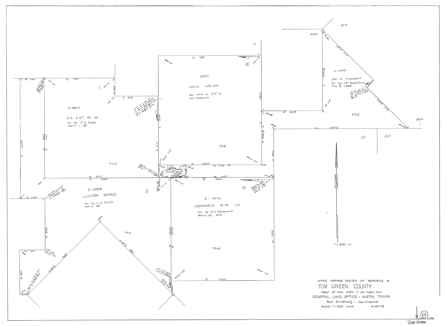
Tom Green County Working Sketch 12
-
Map/Doc
69381
-
Collection
General Map Collection
-
Object Dates
10/24/1975 (Creation Date)
-
Counties
Tom Green
-
Subjects
Surveying Working Sketch
-
Height x Width
30.0 x 41.1 inches
76.2 x 104.4 cm
-
Scale
1" = 200 varas
Part of: General Map Collection
Archer County Working Sketch 5

Print $20.00
- Digital $50.00
Archer County Working Sketch 5
1919
Size 14.7 x 23.4 inches
Map/Doc 67145
Palo Pinto County

Print $20.00
- Digital $50.00
Palo Pinto County
1941
Size 44.9 x 35.9 inches
Map/Doc 77389
Jones County Rolled Sketch 1

Print $20.00
- Digital $50.00
Jones County Rolled Sketch 1
1957
Size 26.1 x 28.3 inches
Map/Doc 6450
Gaines County Rolled Sketch 14

Print $40.00
- Digital $50.00
Gaines County Rolled Sketch 14
Size 23.8 x 325.9 inches
Map/Doc 9030
Bell County Sketch File 4

Print $40.00
- Digital $50.00
Bell County Sketch File 4
1848
Size 15.9 x 12.6 inches
Map/Doc 14369
Laguna Madre from Lone Palmetto Triangulation Station to Gum Pen Triangulation Station

Print $20.00
- Digital $50.00
Laguna Madre from Lone Palmetto Triangulation Station to Gum Pen Triangulation Station
1881
Size 16.2 x 27.5 inches
Map/Doc 73497
Kendall County Sketch File 28

Print $12.00
- Digital $50.00
Kendall County Sketch File 28
1953
Size 14.3 x 8.9 inches
Map/Doc 28733
Starr County Rolled Sketch 19

Print $20.00
- Digital $50.00
Starr County Rolled Sketch 19
1920
Size 20.8 x 24.9 inches
Map/Doc 7803
Wilbarger Co.

Print $40.00
- Digital $50.00
Wilbarger Co.
1889
Size 48.8 x 38.4 inches
Map/Doc 63125
Childress County Working Sketch 7

Print $20.00
- Digital $50.00
Childress County Working Sketch 7
1960
Size 20.7 x 14.8 inches
Map/Doc 68023
Fannin County Rolled Sketch 18G

Print $20.00
- Digital $50.00
Fannin County Rolled Sketch 18G
Size 27.9 x 36.0 inches
Map/Doc 5874
Hale County Sketch File 13

Print $20.00
- Digital $50.00
Hale County Sketch File 13
Size 36.5 x 23.0 inches
Map/Doc 10470
You may also like
Ochiltree County Sketch File 9

Print $14.00
- Digital $50.00
Ochiltree County Sketch File 9
1934
Size 11.1 x 8.8 inches
Map/Doc 33194
[Sketch of Survey 9, Block Z3]
![93089, [Sketch of Survey 9, Block Z3], Twichell Survey Records](https://historictexasmaps.com/wmedia_w700/maps/93089-1.tif.jpg)
Print $2.00
- Digital $50.00
[Sketch of Survey 9, Block Z3]
Size 8.9 x 7.3 inches
Map/Doc 93089
Old Miscellaneous File 39

Print $10.00
- Digital $50.00
Old Miscellaneous File 39
1893
Size 14.2 x 8.8 inches
Map/Doc 75284
Gaines County Rolled Sketch 26

Print $20.00
- Digital $50.00
Gaines County Rolled Sketch 26
1980
Size 28.0 x 15.5 inches
Map/Doc 5940
Maverick County Sketch File 10

Print $22.00
- Digital $50.00
Maverick County Sketch File 10
Size 8.6 x 7.0 inches
Map/Doc 31072
Burnet County Working Sketch 6

Print $20.00
- Digital $50.00
Burnet County Working Sketch 6
1958
Size 20.5 x 31.0 inches
Map/Doc 67849
No. IX - Outline map of the vicinity of Corpus Christi

Print $20.00
- Digital $50.00
No. IX - Outline map of the vicinity of Corpus Christi
Size 24.8 x 18.3 inches
Map/Doc 72967
[Field notes, sketch and legislation regarding the National Road from Dallas at the mouth of the Elm Fork of the Trinity to the mouth of Kiamechi on Red River]
![65469, [Field notes, sketch and legislation regarding the National Road from Dallas at the mouth of the Elm Fork of the Trinity to the mouth of Kiamechi on Red River], General Map Collection](https://historictexasmaps.com/wmedia_w700/pdf_converted_jpg/qi_pdf_thumbnail_19857.jpg)
Print $84.00
- Digital $50.00
[Field notes, sketch and legislation regarding the National Road from Dallas at the mouth of the Elm Fork of the Trinity to the mouth of Kiamechi on Red River]
1844
Size 6.8 x 11.2 inches
Map/Doc 65469
Upton County Rolled Sketch 53

Print $20.00
- Digital $50.00
Upton County Rolled Sketch 53
Size 26.9 x 30.8 inches
Map/Doc 8088
United States - Gulf Coast - Galveston to Rio Grande

Print $20.00
- Digital $50.00
United States - Gulf Coast - Galveston to Rio Grande
Size 27.8 x 18.1 inches
Map/Doc 72740
Shelby County Working Sketch 18

Print $20.00
- Digital $50.00
Shelby County Working Sketch 18
1957
Size 20.7 x 27.4 inches
Map/Doc 63871
W. L. Ellwood's Ranch situated in Lamb and Hockley Counties

Print $40.00
- Digital $50.00
W. L. Ellwood's Ranch situated in Lamb and Hockley Counties
Size 33.0 x 107.4 inches
Map/Doc 93208