Brazoria County Rolled Sketch 21A
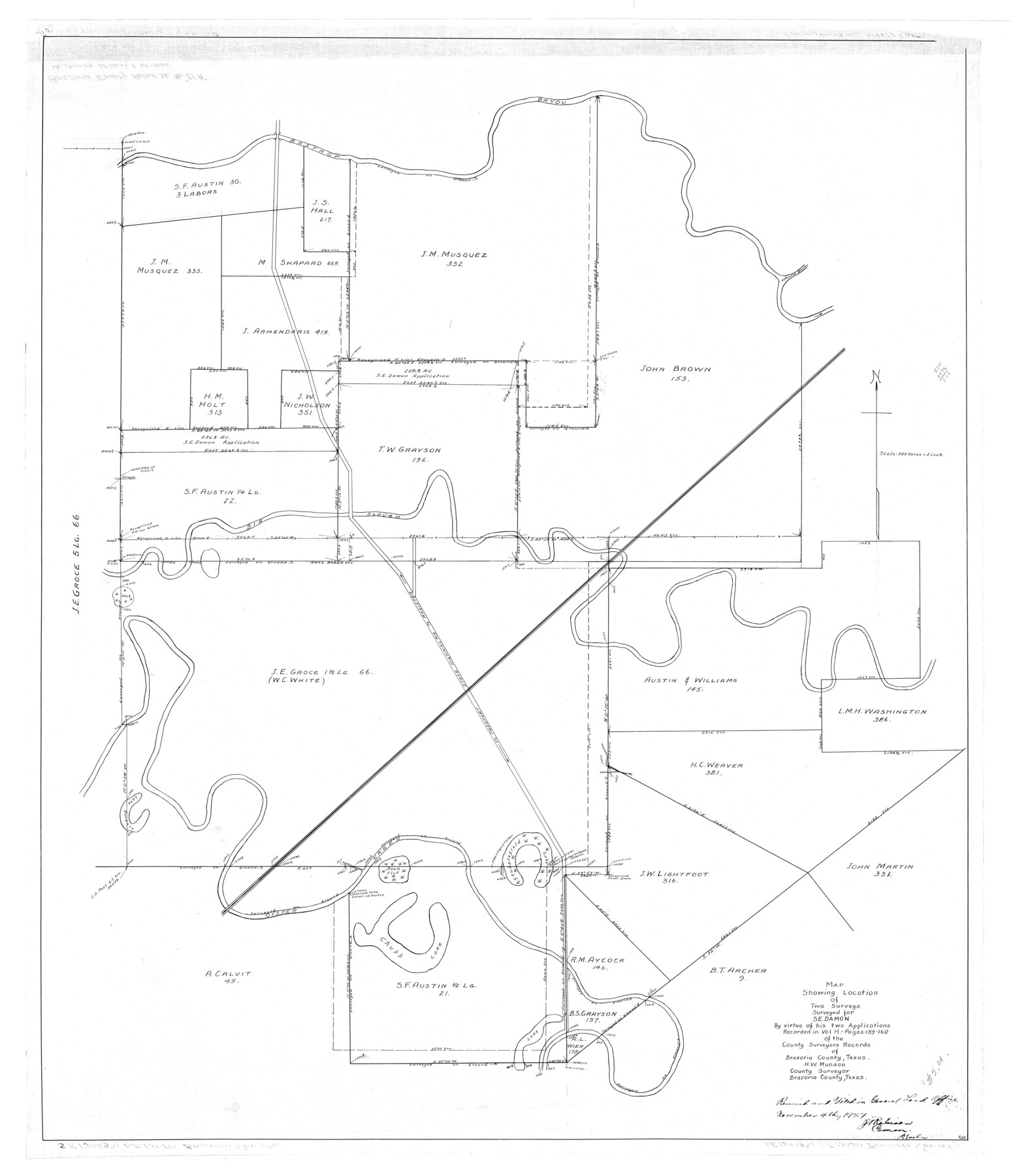
Map showing location of two surveys surveyed for S.E. Damon by virtue of his two applications recorded in Vol. H. Pages: 159-160 of the County Surveyors records of Brazoria County, Texas
-
Map/Doc
8926
-
Collection
General Map Collection
-
Object Dates
1927/11/4 (File Date)
-
People and Organizations
H.W. Munson (Surveyor/Engineer)
-
Counties
Brazoria
-
Subjects
Surveying Rolled Sketch
-
Height x Width
38.6 x 33.2 inches
98.0 x 84.3 cm
-
Scale
1" = 500 varas
Part of: General Map Collection
Comanche County Sketch File 26

Print $20.00
- Digital $50.00
Comanche County Sketch File 26
Size 18.0 x 17.5 inches
Map/Doc 11144
Mosaic composed of aerial photographs - Galveston, Tex.

Print $20.00
- Digital $50.00
Mosaic composed of aerial photographs - Galveston, Tex.
1923
Size 15.3 x 33.3 inches
Map/Doc 97160
Tarrant County Working Sketch 5

Print $20.00
- Digital $50.00
Tarrant County Working Sketch 5
1980
Size 27.7 x 27.3 inches
Map/Doc 62422
Sketch G Showing the Progress of the Survey in Section VII From 1849 to 1852

Print $20.00
- Digital $50.00
Sketch G Showing the Progress of the Survey in Section VII From 1849 to 1852
1852
Size 13.6 x 25.8 inches
Map/Doc 97219
[Right of Way & Track Map, The Texas & Pacific Ry. Co. Main Line]
![64665, [Right of Way & Track Map, The Texas & Pacific Ry. Co. Main Line], General Map Collection](https://historictexasmaps.com/wmedia_w700/maps/64665.tif.jpg)
Print $20.00
- Digital $50.00
[Right of Way & Track Map, The Texas & Pacific Ry. Co. Main Line]
Size 11.0 x 18.4 inches
Map/Doc 64665

Flight Mission No. BQY-4M, Frame 115, Harris County

Print $20.00
- Digital $50.00
Flight Mission No. BQY-4M, Frame 115, Harris County
1953
Size 18.6 x 22.5 inches
Map/Doc 85282

Webb County Working Sketch 36

Print $40.00
- Digital $50.00
Webb County Working Sketch 36
1940
Size 38.4 x 67.3 inches
Map/Doc 72401
DeWitt County Working Sketch 16

Print $20.00
- Digital $50.00
DeWitt County Working Sketch 16
1920
Size 23.0 x 25.1 inches
Map/Doc 69016
Flight Mission No. DCL-7C, Frame 72, Kenedy County

Print $20.00
- Digital $50.00
Flight Mission No. DCL-7C, Frame 72, Kenedy County
1943
Size 15.4 x 15.1 inches
Map/Doc 86058
Polk County Sketch File 28

Print $4.00
- Digital $50.00
Polk County Sketch File 28
Size 8.6 x 9.9 inches
Map/Doc 34198
You may also like
Brewster County Working Sketch 13

Print $20.00
- Digital $50.00
Brewster County Working Sketch 13
1928
Size 39.5 x 43.9 inches
Map/Doc 67546
Orange County Working Sketch 26

Print $20.00
- Digital $50.00
Orange County Working Sketch 26
1953
Size 13.4 x 22.0 inches
Map/Doc 71358
Colorado County Sketch File 4

Print $40.00
- Digital $50.00
Colorado County Sketch File 4
1858
Size 12.8 x 15.7 inches
Map/Doc 18917
Cherokee County Sketch File 31b

Print $6.00
- Digital $50.00
Cherokee County Sketch File 31b
1934
Size 14.2 x 8.9 inches
Map/Doc 18187
Erath County Sketch File 12a

Print $4.00
- Digital $50.00
Erath County Sketch File 12a
1871
Size 12.7 x 8.2 inches
Map/Doc 22283
Brewster County Sketch File 16

Print $46.00
- Digital $50.00
Brewster County Sketch File 16
1936
Size 14.3 x 8.6 inches
Map/Doc 15777
The Chief Justice County of San Augustine. Lands in Conflict with Sabine County

Print $20.00
The Chief Justice County of San Augustine. Lands in Conflict with Sabine County
2020
Size 14.6 x 21.7 inches
Map/Doc 96071
Flight Mission No. DQN-5K, Frame 148, Calhoun County

Print $20.00
- Digital $50.00
Flight Mission No. DQN-5K, Frame 148, Calhoun County
1953
Size 18.6 x 21.9 inches
Map/Doc 84423
Map of the Fort Worth & Denver City Railway, Hartley County, Texas

Print $40.00
- Digital $50.00
Map of the Fort Worth & Denver City Railway, Hartley County, Texas
1887
Size 21.9 x 89.8 inches
Map/Doc 64390
Denton County Working Sketch 12

Print $20.00
- Digital $50.00
Denton County Working Sketch 12
1960
Size 29.8 x 17.3 inches
Map/Doc 68617
Childress County Boundary File 3a

Print $80.00
- Digital $50.00
Childress County Boundary File 3a
Size 30.7 x 70.1 inches
Map/Doc 51354
Houston, (Capital de Tejas)

Print $20.00
- Digital $50.00
Houston, (Capital de Tejas)
1845
Size 6.8 x 10.0 inches
Map/Doc 97238