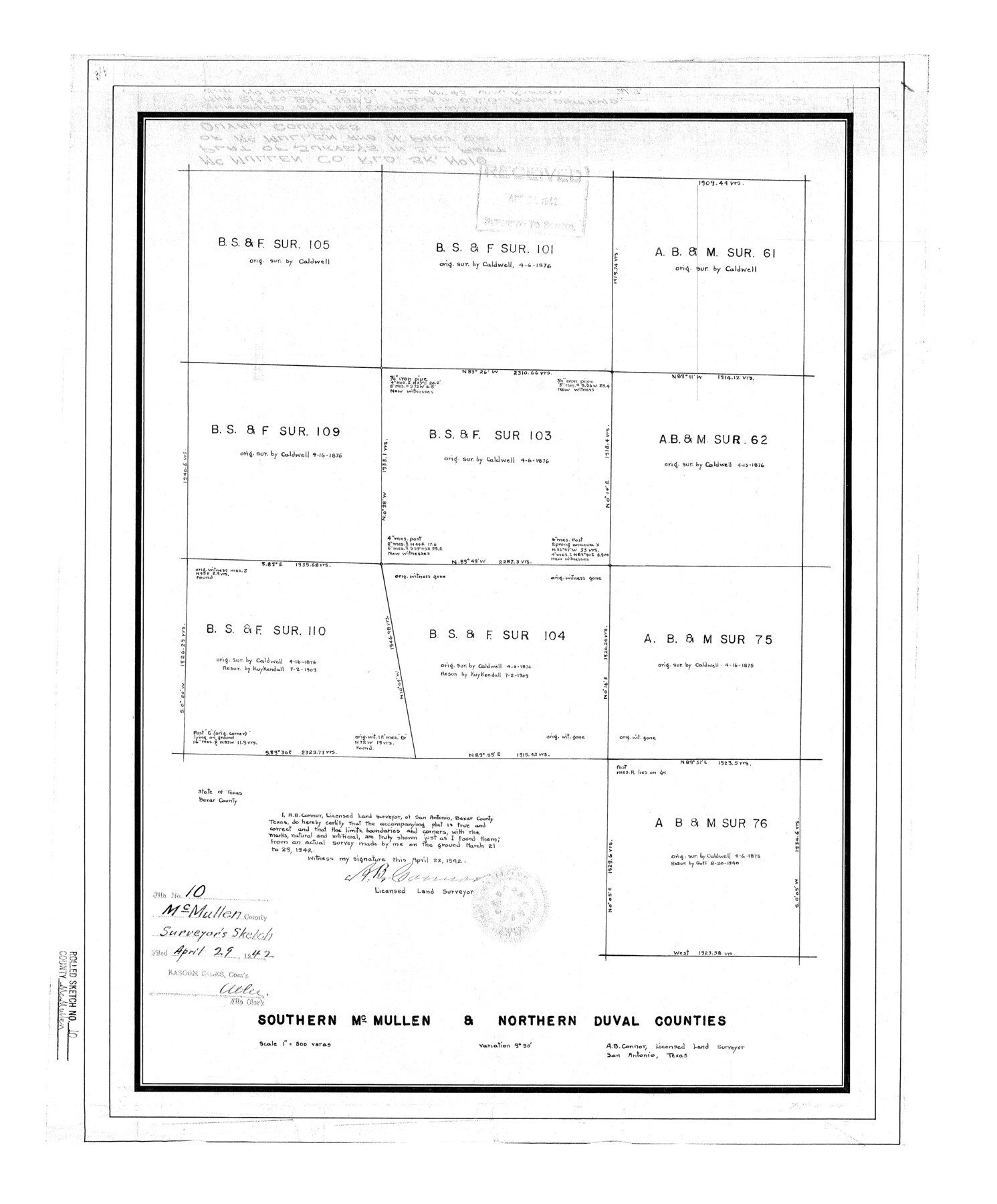
McMullen County Rolled Sketch 10
Southern McMullen & northern Duval Counties
-
Map/Doc
6727
-
Collection
General Map Collection
-
Object Dates
1942/3/21 (Survey Date)
1942/4/22 (Creation Date)
1942/4/29 (File Date)
-
People and Organizations
A.B. Connor (Surveyor/Engineer)
-
Counties
McMullen Duval
-
Subjects
Surveying Rolled Sketch
-
Height x Width
24.0 x 19.9 inches
61.0 x 50.6 cm
-
Scale
1" = 500 varas
-
Comments
See McMullen County Sketch File 43 (31421) for report.
Related maps
McMullen County Sketch File 43

Print $10.00
- Digital $50.00
McMullen County Sketch File 43
1942
Size 14.2 x 8.8 inches
Map/Doc 31421
Part of: General Map Collection
Dimmit County Working Sketch 51

Print $20.00
- Digital $50.00
Dimmit County Working Sketch 51
1986
Size 25.7 x 36.1 inches
Map/Doc 68712
Hale County Sketch File 3a

Print $20.00
- Digital $50.00
Hale County Sketch File 3a
Size 21.1 x 14.6 inches
Map/Doc 11593
Jefferson County Sketch File 33

Print $32.00
- Digital $50.00
Jefferson County Sketch File 33
1934
Size 8.2 x 7.6 inches
Map/Doc 28197
Zavala County Sketch File 11a

Print $10.00
- Digital $50.00
Zavala County Sketch File 11a
1885
Size 11.2 x 8.6 inches
Map/Doc 41272
Walker County Working Sketch 2

Print $20.00
- Digital $50.00
Walker County Working Sketch 2
1918
Size 16.7 x 14.5 inches
Map/Doc 72282
Gonzales County

Print $20.00
- Digital $50.00
Gonzales County
1880
Size 25.3 x 22.6 inches
Map/Doc 3594
Jones County Sketch File 19

Print $56.00
- Digital $50.00
Jones County Sketch File 19
1875
Size 11.1 x 8.6 inches
Map/Doc 28516
Mills County Working Sketch 15

Print $20.00
- Digital $50.00
Mills County Working Sketch 15
1951
Size 38.4 x 41.6 inches
Map/Doc 71045
Liberty County Working Sketch 85

Print $20.00
- Digital $50.00
Liberty County Working Sketch 85
1987
Size 27.2 x 28.3 inches
Map/Doc 70545
Pecos County Working Sketch 119

Print $20.00
- Digital $50.00
Pecos County Working Sketch 119
1973
Size 42.8 x 30.9 inches
Map/Doc 71592
Flight Mission No. DQN-6K, Frame 75, Calhoun County

Print $20.00
- Digital $50.00
Flight Mission No. DQN-6K, Frame 75, Calhoun County
1953
Size 18.6 x 22.2 inches
Map/Doc 84447
Real County Working Sketch 11

Print $20.00
- Digital $50.00
Real County Working Sketch 11
1929
Size 25.8 x 35.6 inches
Map/Doc 71903
You may also like
Garza County Rolled Sketch 5B

Print $20.00
- Digital $50.00
Garza County Rolled Sketch 5B
Size 36.3 x 47.7 inches
Map/Doc 76031
Briscoe County Boundary File 6

Print $4.00
- Digital $50.00
Briscoe County Boundary File 6
Size 10.6 x 8.1 inches
Map/Doc 50804
Atascosa County Sketch File 15a

Print $5.00
- Digital $50.00
Atascosa County Sketch File 15a
1879
Size 17.4 x 8.2 inches
Map/Doc 13777
Smith County Working Sketch 10

Print $20.00
- Digital $50.00
Smith County Working Sketch 10
1952
Size 33.4 x 24.2 inches
Map/Doc 63895
Brazoria County Working Sketch 45

Print $20.00
- Digital $50.00
Brazoria County Working Sketch 45
1988
Size 23.0 x 19.2 inches
Map/Doc 67530
Detail Sketch of A.B. Robertson's Ranch and J.W. James' Ranch situated in Garza and Crosby Counties, Texas

Print $40.00
- Digital $50.00
Detail Sketch of A.B. Robertson's Ranch and J.W. James' Ranch situated in Garza and Crosby Counties, Texas
Size 51.7 x 34.3 inches
Map/Doc 89754
Morris County Rolled Sketch 2A

Print $20.00
- Digital $50.00
Morris County Rolled Sketch 2A
Size 24.0 x 18.8 inches
Map/Doc 10240
Railroad Track Map, H&TCRRCo., Falls County, Texas

Print $4.00
- Digital $50.00
Railroad Track Map, H&TCRRCo., Falls County, Texas
1918
Size 11.4 x 18.7 inches
Map/Doc 62849
Archer County Boundary File 4

Print $54.00
- Digital $50.00
Archer County Boundary File 4
Size 8.9 x 9.7 inches
Map/Doc 50103
San Augustine County Sketch File 4

Print $4.00
San Augustine County Sketch File 4
1849
Size 6.5 x 5.4 inches
Map/Doc 35640
Map of Kinney County

Print $20.00
- Digital $50.00
Map of Kinney County
1875
Size 25.9 x 34.2 inches
Map/Doc 3773
Sheet 2 copied from Peck Book 6 [Strip Map showing T. & P. connecting lines]
![93172, Sheet 2 copied from Peck Book 6 [Strip Map showing T. & P. connecting lines], Twichell Survey Records](https://historictexasmaps.com/wmedia_w700/maps/93172-1.tif.jpg)
Print $40.00
- Digital $50.00
Sheet 2 copied from Peck Book 6 [Strip Map showing T. & P. connecting lines]
1909
Size 6.5 x 53.9 inches
Map/Doc 93172