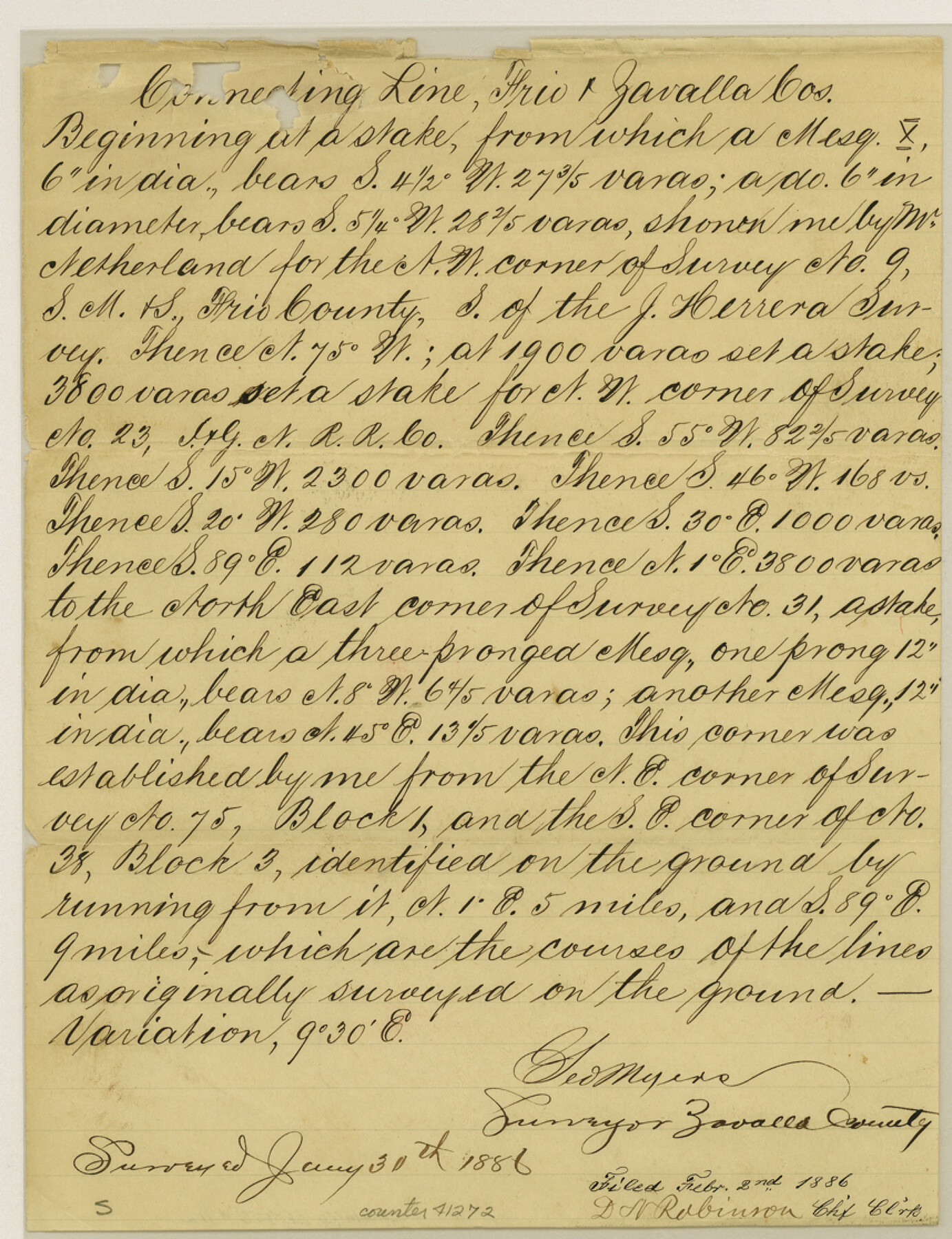
Zavala County Sketch File 11a
[Miscellaneous connecting lines in Zavala and Frio Counties]
-
Map/Doc
41272
-
Collection
General Map Collection
-
Object Dates
1885-1886 (Creation Date)
-
People and Organizations
George Myers (Surveyor/Engineer)
L.L. Everett (Chainman/Field Personnel)
J.E. Ragsdale (Chainman/Field Personnel)
-
Counties
Zavala Frio
-
Subjects
Surveying Sketch File
-
Height x Width
11.2 x 8.6 inches
28.5 x 21.8 cm
-
Medium
paper, manuscript
-
Features
Presidio Road
Loma Vista Creek
Tortugas Creek
Wesache Lake
Part of: General Map Collection
Texas - Official Highway Travel Map

Texas - Official Highway Travel Map
Size 27.4 x 36.4 inches
Map/Doc 94299
Schleicher County Sketch File 46

Print $4.00
- Digital $50.00
Schleicher County Sketch File 46
1958
Size 3.7 x 8.8 inches
Map/Doc 36554
Walker County Working Sketch 4

Print $20.00
- Digital $50.00
Walker County Working Sketch 4
1934
Size 34.9 x 29.7 inches
Map/Doc 72284
Rains County Working Sketch 4

Print $20.00
- Digital $50.00
Rains County Working Sketch 4
1919
Size 27.3 x 25.9 inches
Map/Doc 71830
Motley County Sketch File 33 (S)

Print $6.00
- Digital $50.00
Motley County Sketch File 33 (S)
1914
Size 7.4 x 8.5 inches
Map/Doc 32217
Wood County Working Sketch 23

Print $40.00
- Digital $50.00
Wood County Working Sketch 23
1962
Size 54.9 x 43.5 inches
Map/Doc 78230
Old Miscellaneous File 14

Print $4.00
- Digital $50.00
Old Miscellaneous File 14
1898
Size 11.2 x 8.6 inches
Map/Doc 75449
Jefferson County Rolled Sketch 63

Print $20.00
- Digital $50.00
Jefferson County Rolled Sketch 63
1884
Size 26.5 x 36.4 inches
Map/Doc 6417
Flight Mission No. DAG-26K, Frame 59, Matagorda County

Print $20.00
- Digital $50.00
Flight Mission No. DAG-26K, Frame 59, Matagorda County
1953
Size 18.5 x 22.3 inches
Map/Doc 86579

Liberty County Sketch File 45

Print $4.00
- Digital $50.00
Liberty County Sketch File 45
Size 7.8 x 10.1 inches
Map/Doc 30003
Kuechler's Corners, Texas & Pacific Ry. Co. 80 Mile Reserve

Print $703.00
- Digital $50.00
Kuechler's Corners, Texas & Pacific Ry. Co. 80 Mile Reserve
1934
Size 11.0 x 8.5 inches
Map/Doc 2248
You may also like
Greater Fort Worth City

Print $20.00
- Digital $50.00
Greater Fort Worth City
1919
Size 31.2 x 21.5 inches
Map/Doc 93423
Working Sketch in Collingsworth County [showing East line of County along border with Oklahoma]
![92086, Working Sketch in Collingsworth County [showing East line of County along border with Oklahoma], Twichell Survey Records](https://historictexasmaps.com/wmedia_w700/maps/92086-1.tif.jpg)
Print $20.00
- Digital $50.00
Working Sketch in Collingsworth County [showing East line of County along border with Oklahoma]
1910
Size 4.5 x 25.9 inches
Map/Doc 92086
Roberts County Working Sketch 37

Print $20.00
- Digital $50.00
Roberts County Working Sketch 37
1978
Size 26.6 x 22.5 inches
Map/Doc 63563
Presidio County Rolled Sketch A-1

Print $20.00
- Digital $50.00
Presidio County Rolled Sketch A-1
1889
Size 26.8 x 32.0 inches
Map/Doc 9769
Wise County Working Sketch 16

Print $20.00
- Digital $50.00
Wise County Working Sketch 16
1960
Size 28.0 x 39.0 inches
Map/Doc 72630
The Republic County of Montgomery. January 21, 1841

Print $20.00
The Republic County of Montgomery. January 21, 1841
2020
Size 19.9 x 21.7 inches
Map/Doc 96238
A New and Correct Map of North America, with the West India Islands

Print $20.00
- Digital $50.00
A New and Correct Map of North America, with the West India Islands
1784
Size 44.0 x 52.2 inches
Map/Doc 93828
[Surveys in Henderson County, Nacogdoches/Houston District]
![69735, [Surveys in Henderson County, Nacogdoches/Houston District], General Map Collection](https://historictexasmaps.com/wmedia_w700/maps/69735.tif.jpg)
Print $2.00
- Digital $50.00
[Surveys in Henderson County, Nacogdoches/Houston District]
Size 11.0 x 7.9 inches
Map/Doc 69735
Andrews County Sketch File 11

Print $40.00
- Digital $50.00
Andrews County Sketch File 11
1951
Size 12.3 x 25.8 inches
Map/Doc 10811
Jefferson County Sketch File 21

Print $10.00
- Digital $50.00
Jefferson County Sketch File 21
Size 8.6 x 6.6 inches
Map/Doc 28171
Gonzales County Rolled Sketch 2

Print $20.00
- Digital $50.00
Gonzales County Rolled Sketch 2
2021
Size 24.0 x 35.9 inches
Map/Doc 96581
Presidio County Working Sketch 101

Print $20.00
- Digital $50.00
Presidio County Working Sketch 101
1979
Size 37.6 x 31.0 inches
Map/Doc 71778