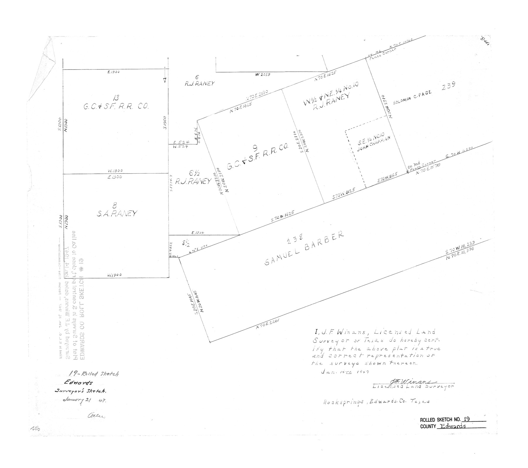
Edwards County Rolled Sketch 19
[Plat of surveys in south central part, close to county line]
-
Map/Doc
5808
-
Collection
General Map Collection
-
Object Dates
1947/1/14 (Creation Date)
1947/1/21 (File Date)
-
People and Organizations
J.F. Winans (Surveyor/Engineer)
-
Counties
Edwards
-
Subjects
Surveying Rolled Sketch
-
Height x Width
21.3 x 24.0 inches
54.1 x 61.0 cm
Part of: General Map Collection
Fort Bend County Boundary File 4

Print $40.00
- Digital $50.00
Fort Bend County Boundary File 4
Size 18.5 x 26.2 inches
Map/Doc 53567
Jefferson County Working Sketch 44

Print $20.00
- Digital $50.00
Jefferson County Working Sketch 44
1960
Size 42.4 x 36.4 inches
Map/Doc 73592
Flight Mission No. CRK-5P, Frame 156, Refugio County

Print $20.00
- Digital $50.00
Flight Mission No. CRK-5P, Frame 156, Refugio County
1956
Size 18.5 x 22.5 inches
Map/Doc 86937
Marion County Working Sketch 27

Print $20.00
- Digital $50.00
Marion County Working Sketch 27
1971
Size 44.8 x 41.0 inches
Map/Doc 70803
Aransas County Rolled Sketch 15B

Print $20.00
- Digital $50.00
Aransas County Rolled Sketch 15B
Size 19.0 x 19.8 inches
Map/Doc 76066
Montgomery County Working Sketch 67

Print $20.00
- Digital $50.00
Montgomery County Working Sketch 67
1972
Size 35.0 x 29.6 inches
Map/Doc 71174
Wilson County Boundary File 2

Print $10.00
- Digital $50.00
Wilson County Boundary File 2
Size 12.3 x 8.3 inches
Map/Doc 60078
Val Verde County Working Sketch 69

Print $20.00
- Digital $50.00
Val Verde County Working Sketch 69
1965
Size 35.6 x 37.3 inches
Map/Doc 72204
Crockett County Working Sketch 29

Print $40.00
- Digital $50.00
Crockett County Working Sketch 29
1924
Size 42.8 x 57.6 inches
Map/Doc 68362
Travis County Working Sketch 12

Print $20.00
- Digital $50.00
Travis County Working Sketch 12
1920
Size 47.8 x 26.1 inches
Map/Doc 69396
Shelby County Working Sketch 19

Print $20.00
- Digital $50.00
Shelby County Working Sketch 19
1969
Size 36.9 x 30.2 inches
Map/Doc 63872
Sutton County Working Sketch 30

Print $20.00
- Digital $50.00
Sutton County Working Sketch 30
1919
Size 42.6 x 16.9 inches
Map/Doc 62373
You may also like
[Block 37, Townships 1 and 2 North]
![91344, [Block 37, Townships 1 and 2 North], Twichell Survey Records](https://historictexasmaps.com/wmedia_w700/maps/91344-1.tif.jpg)
Print $20.00
- Digital $50.00
[Block 37, Townships 1 and 2 North]
Size 13.9 x 34.3 inches
Map/Doc 91344
Callahan County Sketch File 12

Print $40.00
- Digital $50.00
Callahan County Sketch File 12
1872
Size 17.8 x 26.2 inches
Map/Doc 11041
Foard County Sketch File 14

Print $4.00
- Digital $50.00
Foard County Sketch File 14
1885
Size 14.4 x 8.8 inches
Map/Doc 22819
Austin Street Map & Guide

Digital $50.00
Austin Street Map & Guide
Size 35.3 x 23.2 inches
Map/Doc 94434
Young County Sketch File 5

Print $40.00
- Digital $50.00
Young County Sketch File 5
1855
Size 12.8 x 15.6 inches
Map/Doc 49662
Map of Crockett Co.

Print $20.00
- Digital $50.00
Map of Crockett Co.
1894
Size 32.6 x 44.1 inches
Map/Doc 4725
Panola County Working Sketch 38

Print $20.00
- Digital $50.00
Panola County Working Sketch 38
1991
Map/Doc 71447
Mills County Working Sketch 22

Print $20.00
- Digital $50.00
Mills County Working Sketch 22
1984
Size 28.7 x 19.8 inches
Map/Doc 71052
Kenedy County Rolled Sketch 9

Print $20.00
- Digital $50.00
Kenedy County Rolled Sketch 9
Size 27.1 x 41.7 inches
Map/Doc 6469
Stonewall County Working Sketch 28

Print $20.00
- Digital $50.00
Stonewall County Working Sketch 28
1976
Size 34.5 x 39.2 inches
Map/Doc 62335
Galveston County Sketch File 65

Print $70.00
- Digital $50.00
Galveston County Sketch File 65
1892
Size 8.7 x 5.8 inches
Map/Doc 23717
Runnels County Rolled Sketch 18

Print $20.00
- Digital $50.00
Runnels County Rolled Sketch 18
Size 23.1 x 25.3 inches
Map/Doc 7513