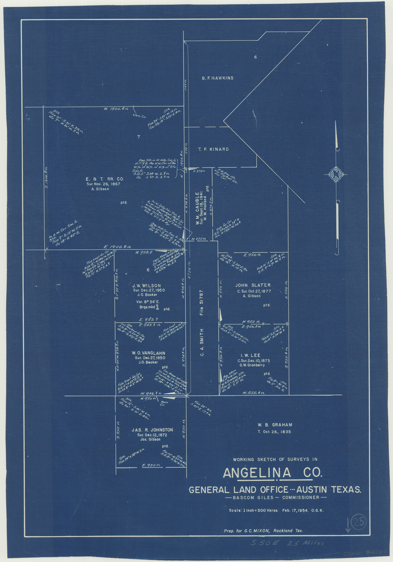
Angelina County Working Sketch 25
-
Map/Doc
67107
-
Collection
General Map Collection
-
Object Dates
2/17/1954 (Creation Date)
-
People and Organizations
Bascom Giles (GLO Commissioner)
Otto G. Kurio (Draftsman)
-
Counties
Angelina
-
Subjects
Surveying Working Sketch
-
Height x Width
25.0 x 17.5 inches
63.5 x 44.5 cm
-
Scale
1" = 300 varas
-
Comments
Surveys located about 25 miles South 50 degrees East from Lufkin, Texas.
Part of: General Map Collection
[Map of Clay County]
![3402, [Map of Clay County], General Map Collection](https://historictexasmaps.com/wmedia_w700/maps/3402-1.tif.jpg)
Print $20.00
- Digital $50.00
[Map of Clay County]
1860
Size 28.3 x 19.1 inches
Map/Doc 3402
San Saba County Working Sketch 7

Print $20.00
- Digital $50.00
San Saba County Working Sketch 7
1952
Size 35.5 x 29.1 inches
Map/Doc 63795
Terrell County Working Sketch 24

Print $20.00
- Digital $50.00
Terrell County Working Sketch 24
1942
Size 16.2 x 41.3 inches
Map/Doc 62174
Flight Mission No. CRK-8P, Frame 121, Refugio County

Print $20.00
- Digital $50.00
Flight Mission No. CRK-8P, Frame 121, Refugio County
1956
Size 18.3 x 22.2 inches
Map/Doc 86976
Flight Mission No. CLL-1N, Frame 157, Willacy County

Print $20.00
- Digital $50.00
Flight Mission No. CLL-1N, Frame 157, Willacy County
1954
Size 18.3 x 22.0 inches
Map/Doc 87048
Orange County Working Sketch 48

Print $20.00
- Digital $50.00
Orange County Working Sketch 48
1991
Size 13.3 x 19.9 inches
Map/Doc 71380
Edwards County Rolled Sketch N

Print $20.00
- Digital $50.00
Edwards County Rolled Sketch N
1934
Size 18.9 x 23.7 inches
Map/Doc 6066
Limestone County Sketch File 27

Print $20.00
- Digital $50.00
Limestone County Sketch File 27
Size 23.2 x 18.8 inches
Map/Doc 12004
San Patricio County Sketch File 12

Print $4.00
San Patricio County Sketch File 12
1859
Size 6.6 x 9.9 inches
Map/Doc 36047
Baylor County Sketch File 17

Print $4.00
- Digital $50.00
Baylor County Sketch File 17
1872
Size 12.8 x 8.5 inches
Map/Doc 14189
Bandera County Rolled Sketch 6

Print $40.00
- Digital $50.00
Bandera County Rolled Sketch 6
Size 55.8 x 41.1 inches
Map/Doc 8439
Rusk County Working Sketch 35

Print $20.00
- Digital $50.00
Rusk County Working Sketch 35
2005
Size 28.7 x 42.0 inches
Map/Doc 83584
You may also like
Runnels County Rolled Sketch 39

Print $20.00
- Digital $50.00
Runnels County Rolled Sketch 39
Size 34.3 x 31.6 inches
Map/Doc 7526
[Sketch showing Block H, Section 11 of Roberts County, including the south bank of the Canadian River]
![91761, [Sketch showing Block H, Section 11 of Roberts County, including the south bank of the Canadian River], Twichell Survey Records](https://historictexasmaps.com/wmedia_w700/maps/91761-1.tif.jpg)
Print $2.00
- Digital $50.00
[Sketch showing Block H, Section 11 of Roberts County, including the south bank of the Canadian River]
1919
Size 14.4 x 8.8 inches
Map/Doc 91761
Flight Mission No. CGI-3N, Frame 160, Cameron County

Print $20.00
- Digital $50.00
Flight Mission No. CGI-3N, Frame 160, Cameron County
1954
Size 18.5 x 22.3 inches
Map/Doc 84624
Taylor County Sketch File 2

Print $20.00
- Digital $50.00
Taylor County Sketch File 2
Size 13.8 x 18.4 inches
Map/Doc 12408
Harris County Rolled Sketch T1

Print $20.00
- Digital $50.00
Harris County Rolled Sketch T1
1916
Size 29.8 x 24.3 inches
Map/Doc 6144

Martin-Ameen Addition, City of Lubbock, South 100 Acres of Southeast Quarter, Section 5, Block E

Print $20.00
- Digital $50.00
Martin-Ameen Addition, City of Lubbock, South 100 Acres of Southeast Quarter, Section 5, Block E
Size 30.9 x 24.6 inches
Map/Doc 92737
Brazoria County NRC Article 33.136 Sketch 17

Print $88.00
- Digital $50.00
Brazoria County NRC Article 33.136 Sketch 17
2015
Size 22.0 x 34.0 inches
Map/Doc 95020
Borden County Sketch File 1

Print $6.00
- Digital $50.00
Borden County Sketch File 1
Size 16.2 x 11.0 inches
Map/Doc 14701
Jefferson County Rolled Sketch 53

Print $20.00
- Digital $50.00
Jefferson County Rolled Sketch 53
1969
Size 33.0 x 34.0 inches
Map/Doc 9309
Angelina County Sketch File 23

Print $20.00
- Digital $50.00
Angelina County Sketch File 23
Size 13.5 x 8.1 inches
Map/Doc 13053
