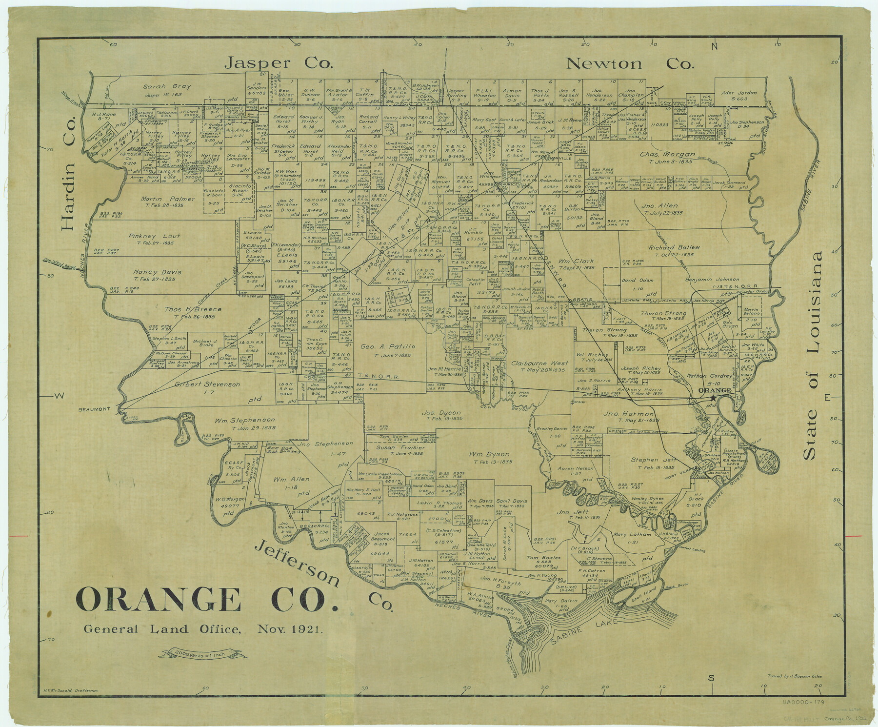
Orange Co.
-
Map/Doc
66962
-
Collection
General Map Collection
-
Object Dates
1921 (Creation Date)
-
People and Organizations
Texas General Land Office (Publisher)
H.F. McDonald (Draftsman)
H.F. McDonald (Compiler)
-
Counties
Orange
-
Subjects
County
-
Height x Width
24.9 x 30.1 inches
63.2 x 76.5 cm
-
Comments
Traced by J. Bascom Giles.
Part of: General Map Collection
Franklin County Sketch File 2a

Print $6.00
- Digital $50.00
Franklin County Sketch File 2a
1857
Size 8.6 x 10.5 inches
Map/Doc 23012
Stephens County Boundary File 81

Print $44.00
- Digital $50.00
Stephens County Boundary File 81
Size 9.2 x 3.8 inches
Map/Doc 58906
Pecos County Rolled Sketch 152

Print $20.00
- Digital $50.00
Pecos County Rolled Sketch 152
1960
Size 38.8 x 43.7 inches
Map/Doc 9736
Flight Mission No. BQR-13K, Frame 116, Brazoria County

Print $20.00
- Digital $50.00
Flight Mission No. BQR-13K, Frame 116, Brazoria County
1952
Size 18.7 x 22.4 inches
Map/Doc 84077
Burnet County Sketch File 26

Print $42.00
- Digital $50.00
Burnet County Sketch File 26
Size 16.2 x 12.7 inches
Map/Doc 16727
Shackelford County Working Sketch 4

Print $20.00
- Digital $50.00
Shackelford County Working Sketch 4
1935
Size 24.8 x 36.7 inches
Map/Doc 63844
Jeff Davis County Working Sketch Graphic Index - west part

Print $20.00
- Digital $50.00
Jeff Davis County Working Sketch Graphic Index - west part
1977
Size 34.0 x 45.3 inches
Map/Doc 76594
Carson County Boundary File 7

Print $64.00
- Digital $50.00
Carson County Boundary File 7
Size 9.3 x 6.9 inches
Map/Doc 51157
Val Verde County Working Sketch 71

Print $40.00
- Digital $50.00
Val Verde County Working Sketch 71
1966
Size 27.0 x 62.3 inches
Map/Doc 72206
Newton County Sketch File 44

Print $8.00
- Digital $50.00
Newton County Sketch File 44
1945
Size 11.2 x 8.6 inches
Map/Doc 32441
Borden County Working Sketch 16

Print $40.00
- Digital $50.00
Borden County Working Sketch 16
2007
Size 48.0 x 29.4 inches
Map/Doc 87206
Gaines County Rolled Sketch 14A

Print $40.00
- Digital $50.00
Gaines County Rolled Sketch 14A
1940
Size 24.8 x 129.0 inches
Map/Doc 9031
You may also like
General Highway Map. Detail of Cities and Towns in Grayson County, Texas [Denison and Sherman]
![79486, General Highway Map. Detail of Cities and Towns in Grayson County, Texas [Denison and Sherman], Texas State Library and Archives](https://historictexasmaps.com/wmedia_w700/maps/79486.tif.jpg)
Print $20.00
General Highway Map. Detail of Cities and Towns in Grayson County, Texas [Denison and Sherman]
1961
Size 18.1 x 24.6 inches
Map/Doc 79486
Schleicher County Rolled Sketch 10

Print $20.00
- Digital $50.00
Schleicher County Rolled Sketch 10
Size 28.9 x 29.1 inches
Map/Doc 7752
Potter County Boundary File 3

Print $10.00
- Digital $50.00
Potter County Boundary File 3
Size 5.8 x 8.9 inches
Map/Doc 57974
Nueces County Sketch File 6

Print $20.00
- Digital $50.00
Nueces County Sketch File 6
Size 15.0 x 22.2 inches
Map/Doc 42175
Maverick County Sketch File 28

Print $4.00
- Digital $50.00
Maverick County Sketch File 28
1893
Size 11.0 x 8.9 inches
Map/Doc 31163
Fannin County Sketch File 11

Print $6.00
- Digital $50.00
Fannin County Sketch File 11
1860
Size 9.9 x 7.4 inches
Map/Doc 22457
Stonewall County Sketch File 16

Print $16.00
- Digital $50.00
Stonewall County Sketch File 16
1902
Size 12.8 x 8.3 inches
Map/Doc 37266
Map of King County

Print $20.00
- Digital $50.00
Map of King County
1903
Size 45.4 x 42.9 inches
Map/Doc 66892
Flight Mission No. BRE-2P, Frame 131, Nueces County

Print $20.00
- Digital $50.00
Flight Mission No. BRE-2P, Frame 131, Nueces County
1956
Size 18.6 x 22.5 inches
Map/Doc 86804
Flight Mission No. CRK-7P, Frame 27, Refugio County

Print $20.00
- Digital $50.00
Flight Mission No. CRK-7P, Frame 27, Refugio County
1956
Size 18.3 x 22.1 inches
Map/Doc 86947
Flight Mission No. DAG-18K, Frame 188, Matagorda County

Print $20.00
- Digital $50.00
Flight Mission No. DAG-18K, Frame 188, Matagorda County
1952
Size 18.6 x 22.3 inches
Map/Doc 86380
[University Lands Blocks 16, 18, 19 and 20]
![91593, [University Lands Blocks 16, 18, 19 and 20], Twichell Survey Records](https://historictexasmaps.com/wmedia_w700/maps/91593-1.tif.jpg)
Print $3.00
- Digital $50.00
[University Lands Blocks 16, 18, 19 and 20]
Size 8.8 x 16.8 inches
Map/Doc 91593