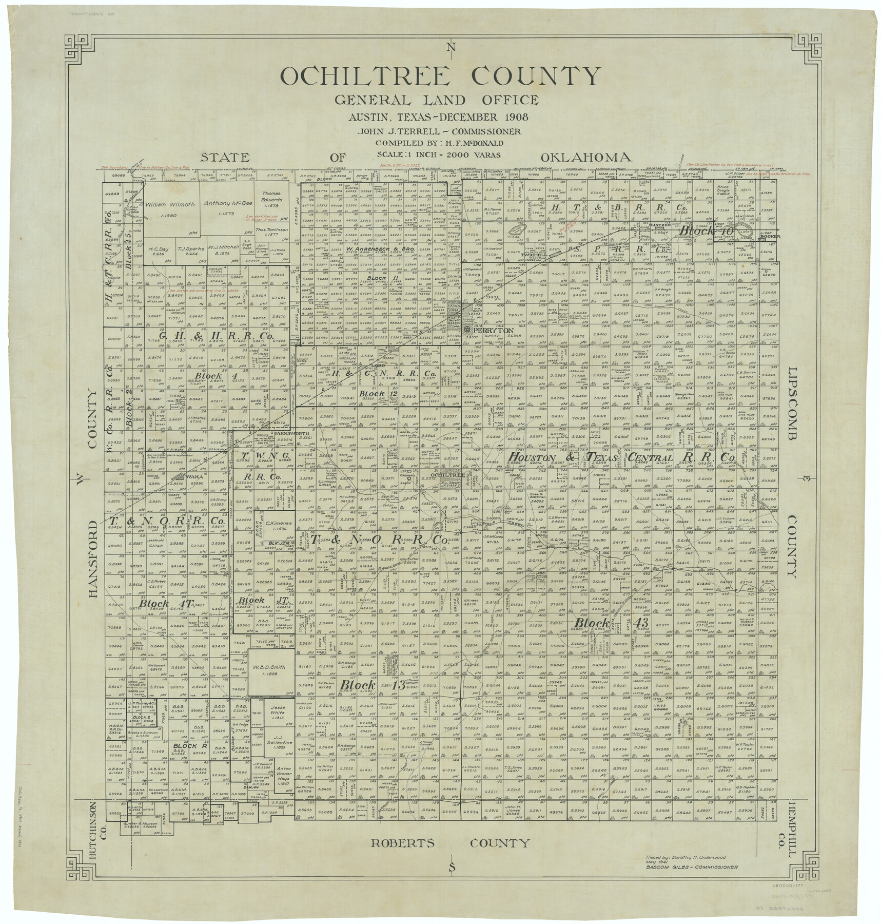
Ochiltree County
-
Map/Doc
66959
-
Collection
General Map Collection
-
Object Dates
1908 (Creation Date)
-
People and Organizations
Texas General Land Office (Publisher)
John J. Terrell (GLO Commissioner)
H.F. McDonald (Compiler)
-
Counties
Ochiltree
-
Subjects
County
-
Height x Width
42.5 x 40.6 inches
108.0 x 103.1 cm
-
Comments
Traced in May 1941 by Dorothy H. Underwood.
Part of: General Map Collection
Panola County Working Sketch 31

Print $20.00
- Digital $50.00
Panola County Working Sketch 31
1981
Map/Doc 71440
Flight Mission No. DQN-1K, Frame 151, Calhoun County

Print $20.00
- Digital $50.00
Flight Mission No. DQN-1K, Frame 151, Calhoun County
1953
Size 18.6 x 22.3 inches
Map/Doc 84210
Amistad International Reservoir on Rio Grande 97

Print $20.00
- Digital $50.00
Amistad International Reservoir on Rio Grande 97
1950
Size 28.5 x 41.1 inches
Map/Doc 75528
Brazoria County Working Sketch 44

Print $20.00
- Digital $50.00
Brazoria County Working Sketch 44
1988
Size 26.6 x 24.9 inches
Map/Doc 67529

Hale County Sketch File 27

Print $20.00
- Digital $50.00
Hale County Sketch File 27
Size 12.1 x 28.5 inches
Map/Doc 11598
Kimble County Sketch File 5

Print $4.00
- Digital $50.00
Kimble County Sketch File 5
1858
Size 7.9 x 5.5 inches
Map/Doc 28916
Clay County Boundary File 13

Print $48.00
- Digital $50.00
Clay County Boundary File 13
Size 10.6 x 9.1 inches
Map/Doc 51410

Flight Mission No. DQO-8K, Frame 56, Galveston County

Print $20.00
- Digital $50.00
Flight Mission No. DQO-8K, Frame 56, Galveston County
1952
Size 18.7 x 17.6 inches
Map/Doc 85163
Flight Mission No. BRE-2P, Frame 110, Nueces County

Print $20.00
- Digital $50.00
Flight Mission No. BRE-2P, Frame 110, Nueces County
1956
Size 18.6 x 22.6 inches
Map/Doc 86796
Flight Mission No. CGI-3N, Frame 76, Cameron County

Print $20.00
- Digital $50.00
Flight Mission No. CGI-3N, Frame 76, Cameron County
1954
Size 18.5 x 22.1 inches
Map/Doc 84570
You may also like
Young County Working Sketch 16

Print $20.00
- Digital $50.00
Young County Working Sketch 16
1955
Size 23.8 x 21.7 inches
Map/Doc 62039
Amistad International Reservoir on Rio Grande 78

Print $20.00
- Digital $50.00
Amistad International Reservoir on Rio Grande 78
1949
Size 28.5 x 40.2 inches
Map/Doc 75506
Knox County Rolled Sketch 11

Print $20.00
- Digital $50.00
Knox County Rolled Sketch 11
Size 24.4 x 17.3 inches
Map/Doc 6557
Collin County Boundary File 4 and 4a

Print $160.00
- Digital $50.00
Collin County Boundary File 4 and 4a
Size 11.9 x 8.5 inches
Map/Doc 51691
Duval County Working Sketch 8

Print $20.00
- Digital $50.00
Duval County Working Sketch 8
1935
Size 18.6 x 29.2 inches
Map/Doc 68721

[East line of Childress County along border of Oklahoma]
![91988, [East line of Childress County along border of Oklahoma], Twichell Survey Records](https://historictexasmaps.com/wmedia_w700/maps/91988-1.tif.jpg)
Print $20.00
- Digital $50.00
[East line of Childress County along border of Oklahoma]
Size 30.1 x 8.6 inches
Map/Doc 91988
Southern Part of Laguna Madre

Print $20.00
- Digital $50.00
Southern Part of Laguna Madre
1949
Size 44.5 x 35.4 inches
Map/Doc 73535
Kimble County Working Sketch 21

Print $20.00
- Digital $50.00
Kimble County Working Sketch 21
1929
Size 24.1 x 15.3 inches
Map/Doc 70089
Foard County Working Sketch 2

Print $20.00
- Digital $50.00
Foard County Working Sketch 2
1911
Size 26.3 x 41.4 inches
Map/Doc 69192
Tarrant County Sketch File 8

Print $4.00
- Digital $50.00
Tarrant County Sketch File 8
1858
Size 8.1 x 10.1 inches
Map/Doc 37687
[A. B. & M. Block 2]
![91794, [A. B. & M. Block 2], Twichell Survey Records](https://historictexasmaps.com/wmedia_w700/maps/91794-1.tif.jpg)
Print $2.00
- Digital $50.00
[A. B. & M. Block 2]
Size 7.1 x 14.1 inches
Map/Doc 91794