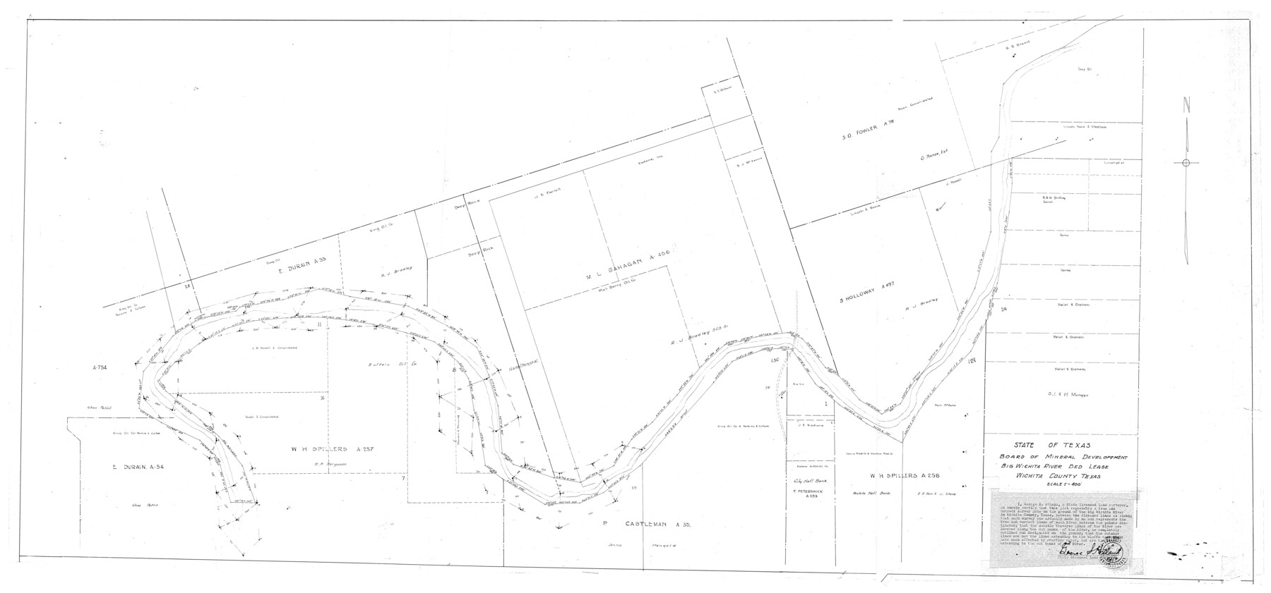
Wichita County Rolled Sketch 14A
Big Wichita River Bed lease, Wichita County, Texas
-
Map/Doc
10138
-
Collection
General Map Collection
-
People and Organizations
George S. Hiland (Surveyor/Engineer)
-
Counties
Wichita
-
Subjects
Surveying Rolled Sketch
-
Height x Width
28.0 x 59.9 inches
71.1 x 152.2 cm
-
Scale
1" = 400 feet
Part of: General Map Collection

Collin County

Print $20.00
- Digital $50.00
Collin County
1975
Size 43.2 x 40.1 inches
Map/Doc 73110
Throckmorton County

Print $20.00
- Digital $50.00
Throckmorton County
1885
Size 24.9 x 18.7 inches
Map/Doc 4080
Flight Mission No. DQO-8K, Frame 83, Galveston County

Print $20.00
- Digital $50.00
Flight Mission No. DQO-8K, Frame 83, Galveston County
1952
Size 18.7 x 22.3 inches
Map/Doc 85185
Moore County Sketch File 6

Print $16.00
- Digital $50.00
Moore County Sketch File 6
1902
Size 7.3 x 8.6 inches
Map/Doc 31939
Flight Mission No. DCL-7C, Frame 15, Kenedy County

Print $20.00
- Digital $50.00
Flight Mission No. DCL-7C, Frame 15, Kenedy County
1943
Size 15.4 x 15.3 inches
Map/Doc 86007
[Surveys in Austin's Colony along the Brazos River]
![213, [Surveys in Austin's Colony along the Brazos River], General Map Collection](https://historictexasmaps.com/wmedia_w700/maps/213.tif.jpg)
Print $20.00
- Digital $50.00
[Surveys in Austin's Colony along the Brazos River]
1824
Size 12.9 x 14.5 inches
Map/Doc 213
Trinity River, Levee Improvement Districts, Widths of Floodways/Chambers Creek

Print $6.00
- Digital $50.00
Trinity River, Levee Improvement Districts, Widths of Floodways/Chambers Creek
1921
Size 24.9 x 31.3 inches
Map/Doc 65256
Flight Mission No. CUG-2P, Frame 86, Kleberg County

Print $20.00
- Digital $50.00
Flight Mission No. CUG-2P, Frame 86, Kleberg County
1956
Size 18.5 x 22.2 inches
Map/Doc 86218
Edwards County Sketch File 34

Print $20.00
- Digital $50.00
Edwards County Sketch File 34
Size 16.8 x 19.0 inches
Map/Doc 11434
Reeves County Working Sketch 15

Print $40.00
- Digital $50.00
Reeves County Working Sketch 15
1961
Size 43.0 x 53.1 inches
Map/Doc 63458
Flight Mission No. DCL-7C, Frame 22, Kenedy County

Print $20.00
- Digital $50.00
Flight Mission No. DCL-7C, Frame 22, Kenedy County
1943
Size 15.4 x 15.2 inches
Map/Doc 86014
You may also like
Midland County

Print $20.00
- Digital $50.00
Midland County
1930
Size 44.9 x 38.5 inches
Map/Doc 73239
Cottle County Working Sketch 6

Print $20.00
- Digital $50.00
Cottle County Working Sketch 6
1927
Size 23.0 x 29.3 inches
Map/Doc 68316
[B. S. & F. Block 9]
![91814, [B. S. & F. Block 9], Twichell Survey Records](https://historictexasmaps.com/wmedia_w700/maps/91814-1.tif.jpg)
Print $20.00
- Digital $50.00
[B. S. & F. Block 9]
Size 25.1 x 35.7 inches
Map/Doc 91814
Flight Mission No. CRC-3R, Frame 21, Chambers County

Print $20.00
- Digital $50.00
Flight Mission No. CRC-3R, Frame 21, Chambers County
1956
Size 18.6 x 22.2 inches
Map/Doc 84795
Map of the State of Texas engraved to illustrate Mitchell's school and family geography

Print $20.00
- Digital $50.00
Map of the State of Texas engraved to illustrate Mitchell's school and family geography
1846
Size 11.8 x 9.5 inches
Map/Doc 93498
Map of Portion of the Gulf of Mexico Adjoining Jefferson County Showing Subdivision Thereof for Mineral Development

Print $20.00
- Digital $50.00
Map of Portion of the Gulf of Mexico Adjoining Jefferson County Showing Subdivision Thereof for Mineral Development
1937
Size 20.5 x 39.0 inches
Map/Doc 3020
Brewster County Rolled Sketch 122

Print $20.00
- Digital $50.00
Brewster County Rolled Sketch 122
1974
Size 33.4 x 24.8 inches
Map/Doc 5296
[F. W. & D. C. Ry. Co. Alignment and Right of Way Map, Clay County]
![64746, [F. W. & D. C. Ry. Co. Alignment and Right of Way Map, Clay County], General Map Collection](https://historictexasmaps.com/wmedia_w700/maps/64746-GC.tif.jpg)
Print $20.00
- Digital $50.00
[F. W. & D. C. Ry. Co. Alignment and Right of Way Map, Clay County]
1927
Size 18.7 x 11.9 inches
Map/Doc 64746
Duval County Rolled Sketch 42

Print $20.00
- Digital $50.00
Duval County Rolled Sketch 42
1973
Size 23.6 x 29.8 inches
Map/Doc 5759
[Movements & Objectives of the 143rd & 144th Infantry on October 12-13, 1918, Appendix E, No.1]
![94126, [Movements & Objectives of the 143rd & 144th Infantry on October 12-13, 1918, Appendix E, No.1], Non-GLO Digital Images](https://historictexasmaps.com/wmedia_w700/maps/94126-1.tif.jpg)
Print $20.00
[Movements & Objectives of the 143rd & 144th Infantry on October 12-13, 1918, Appendix E, No.1]
1918
Size 22.5 x 20.0 inches
Map/Doc 94126
Kimble County Working Sketch 90

Print $20.00
- Digital $50.00
Kimble County Working Sketch 90
1979
Size 17.3 x 28.2 inches
Map/Doc 70158
San Jacinto County Sketch File 17

Print $40.00
San Jacinto County Sketch File 17
1934
Size 60.1 x 26.3 inches
Map/Doc 10598