Calhoun County Rolled Sketch 12
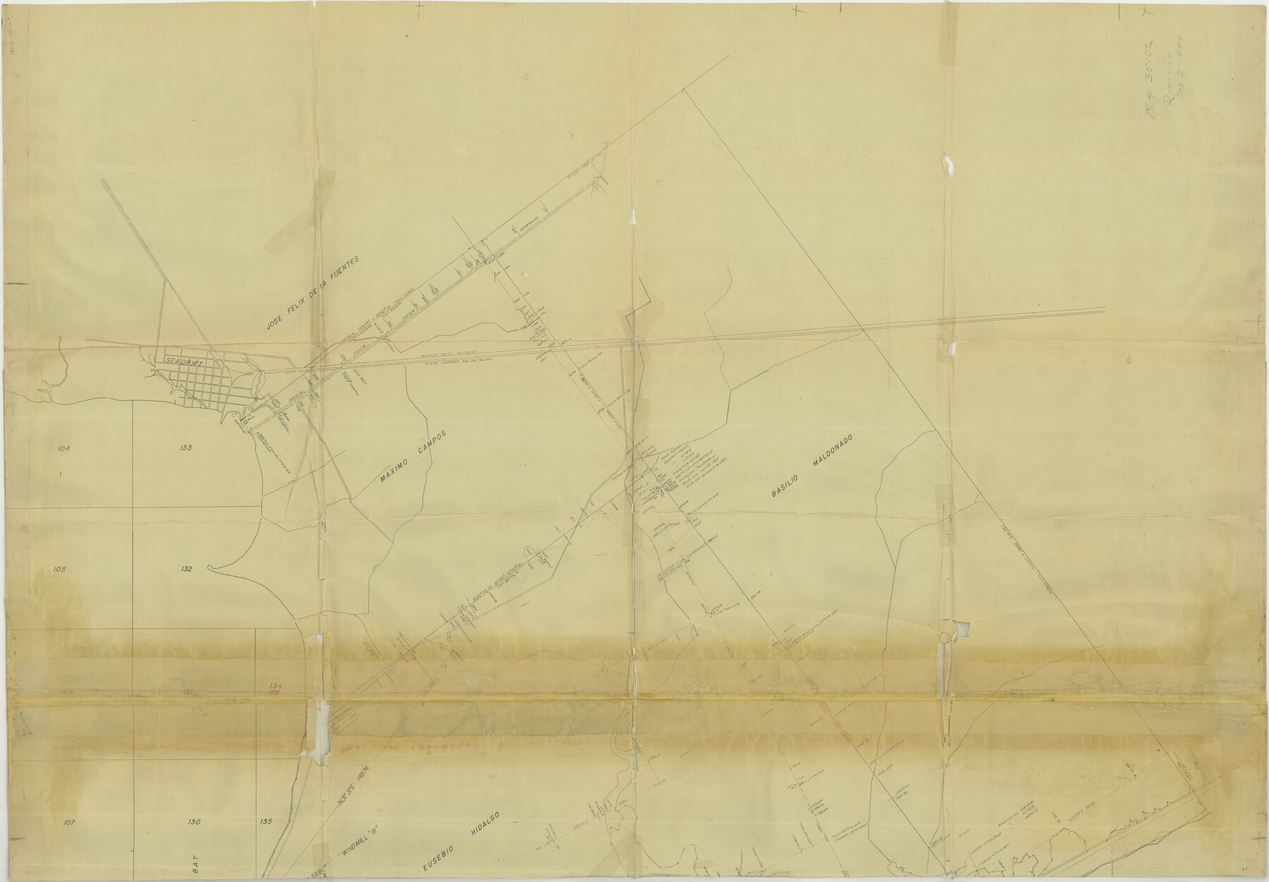
[Map showing survey of State of Texas submerged lease sections nos. 151, 152, 153, 154, 155, 167, & 168 in San Antonio and Espiritu Santos Bays, also surveys of J. Olcott Phillips applications nos. SF 14174 & MA 35102 - North part]
-
Map/Doc
66845
-
Collection
General Map Collection
-
Object Dates
2/18/1940 - 4/23/1940 (Creation Date)
-
People and Organizations
J.S. Boyles (Surveyor/Engineer)
-
Counties
Calhoun
-
Subjects
Surveying Rolled Sketch
-
Height x Width
37.9 x 54.6 inches
96.3 x 138.7 cm
-
Scale
1" = 360 varas
-
Comments
North part of map. For south part, see 43619.
For original flat file envelope, click "Download PDF" link above.
Related maps
Calhoun County Rolled Sketch 12

Print $40.00
- Digital $50.00
Calhoun County Rolled Sketch 12
1940
Size 30.2 x 54.8 inches
Map/Doc 43619
Part of: General Map Collection
Hardin County Sketch File 47

Print $4.00
- Digital $50.00
Hardin County Sketch File 47
1875
Size 7.2 x 7.2 inches
Map/Doc 25200
Haskell County Rolled Sketch 9

Print $20.00
- Digital $50.00
Haskell County Rolled Sketch 9
Size 16.4 x 34.3 inches
Map/Doc 6168
Map of Scurry County

Print $20.00
- Digital $50.00
Map of Scurry County
1899
Size 39.7 x 33.6 inches
Map/Doc 16812
Borden County Rolled Sketch 3

Print $20.00
- Digital $50.00
Borden County Rolled Sketch 3
1908
Size 29.0 x 33.6 inches
Map/Doc 5155
Harris County Rolled Sketch 88

Print $20.00
- Digital $50.00
Harris County Rolled Sketch 88
1935
Size 19.2 x 22.5 inches
Map/Doc 6123
Palo Pinto County Rolled Sketch 5

Print $40.00
- Digital $50.00
Palo Pinto County Rolled Sketch 5
1917
Size 53.8 x 35.8 inches
Map/Doc 76022
San Luis Pass to East Matagorda Bay

Print $40.00
- Digital $50.00
San Luis Pass to East Matagorda Bay
1991
Size 35.0 x 48.8 inches
Map/Doc 69972
Live Oak County Boundary File 60c

Print $4.00
- Digital $50.00
Live Oak County Boundary File 60c
Size 14.0 x 8.7 inches
Map/Doc 56421
Cass County Working Sketch 47a

Print $20.00
- Digital $50.00
Cass County Working Sketch 47a
1991
Size 29.5 x 39.5 inches
Map/Doc 67950
Hardin County Sketch File 2

Print $7.00
- Digital $50.00
Hardin County Sketch File 2
Size 12.7 x 8.4 inches
Map/Doc 25083
Montgomery County Texas Historical Map

Montgomery County Texas Historical Map
Size 23.2 x 35.3 inches
Map/Doc 94404
Randall County Rolled Sketch 6

Print $20.00
- Digital $50.00
Randall County Rolled Sketch 6
Size 25.0 x 23.9 inches
Map/Doc 7426
You may also like
Uvalde County Working Sketch 22

Print $20.00
- Digital $50.00
Uvalde County Working Sketch 22
1950
Size 26.1 x 18.5 inches
Map/Doc 72092
Travis County Working Sketch 48

Print $40.00
- Digital $50.00
Travis County Working Sketch 48
1981
Size 53.7 x 40.3 inches
Map/Doc 69432
Hudspeth County Rolled Sketch 41

Print $40.00
- Digital $50.00
Hudspeth County Rolled Sketch 41
1947
Size 12.6 x 83.1 inches
Map/Doc 76043
Travis County Working Sketch 51

Print $20.00
- Digital $50.00
Travis County Working Sketch 51
1984
Size 25.4 x 19.7 inches
Map/Doc 69435
Flight Mission No. CRE-3R, Frame 41, Jackson County

Print $20.00
- Digital $50.00
Flight Mission No. CRE-3R, Frame 41, Jackson County
1956
Size 18.6 x 22.4 inches
Map/Doc 85388
Flight Mission No. CRC-2R, Frame 123, Chambers County

Print $20.00
- Digital $50.00
Flight Mission No. CRC-2R, Frame 123, Chambers County
1956
Size 18.6 x 22.4 inches
Map/Doc 84747
Karnes County Boundary File 1

Print $14.00
- Digital $50.00
Karnes County Boundary File 1
Size 8.5 x 7.0 inches
Map/Doc 55679
Sketch F No. 2 Showing the progress of the Survey of Cedar Keys, Bahia Honda, Key Biscayne, Key West & Dry Tortugas In Section No. VI

Print $20.00
- Digital $50.00
Sketch F No. 2 Showing the progress of the Survey of Cedar Keys, Bahia Honda, Key Biscayne, Key West & Dry Tortugas In Section No. VI
1849
Size 10.8 x 18.3 inches
Map/Doc 97217
Young County Rolled Sketch 13

Print $20.00
- Digital $50.00
Young County Rolled Sketch 13
1966
Size 24.8 x 16.9 inches
Map/Doc 8301
Outer Continental Shelf Leasing Maps (Louisiana Offshore Operations)

Print $20.00
- Digital $50.00
Outer Continental Shelf Leasing Maps (Louisiana Offshore Operations)
1954
Size 11.3 x 12.4 inches
Map/Doc 76117
![91538, [Block 3T], Twichell Survey Records](https://historictexasmaps.com/wmedia_w700/maps/91538-1.tif.jpg)
[Nueces Bay Islands and Nesting Birds]
![60311, [Nueces Bay Islands and Nesting Birds], General Map Collection](https://historictexasmaps.com/wmedia_w700/maps/60311.tif.jpg)
Print $2.00
- Digital $50.00
[Nueces Bay Islands and Nesting Birds]
1940
Size 11.5 x 7.1 inches
Map/Doc 60311