Harris County Rolled Sketch 88
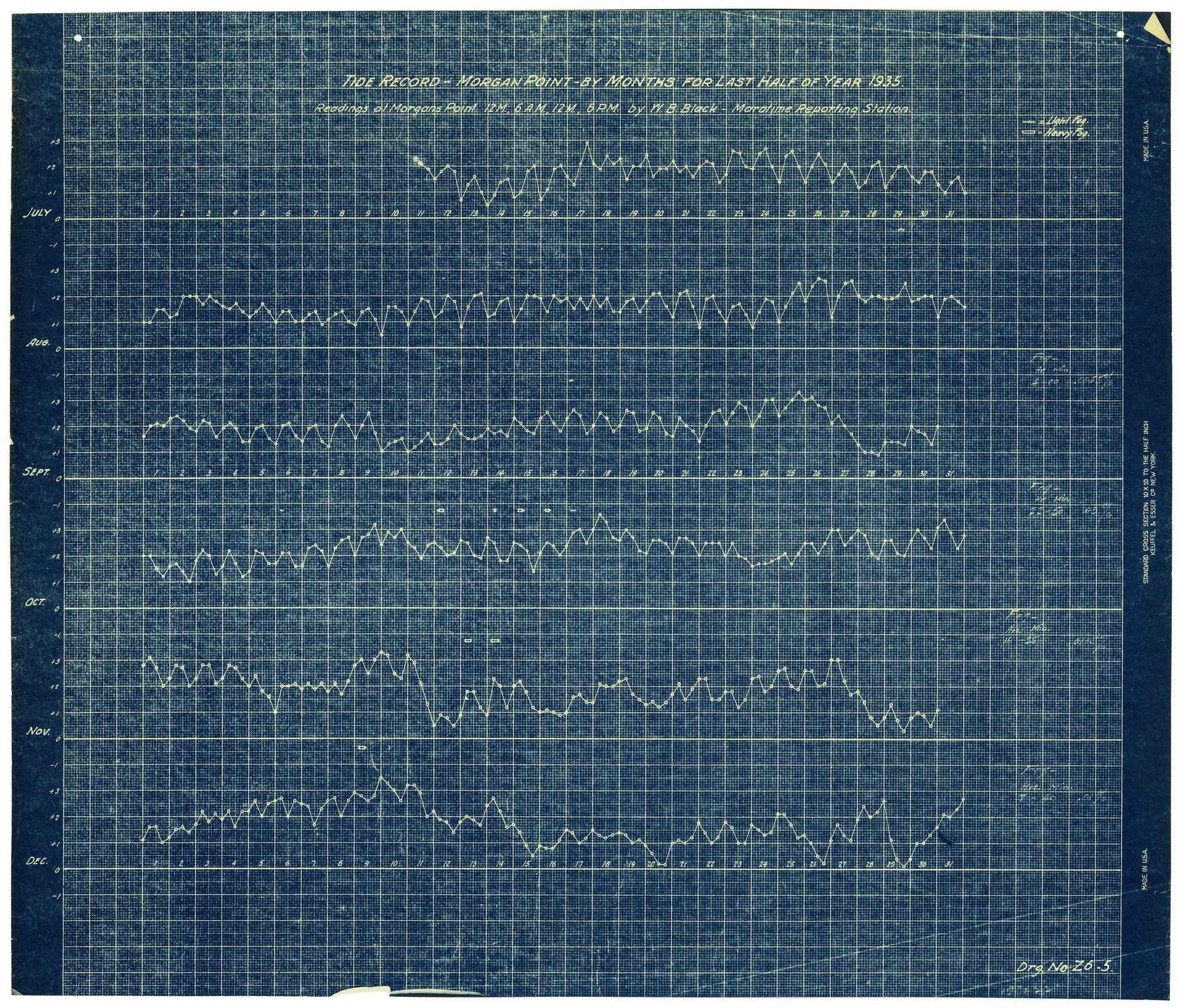
Tide Record - Morgan Point - by months for last half of year 1935 - Readings at Morgan's Point 12 M., 6 A.M., 12 M., 6 P. M.
-
Map/Doc
6123
-
Collection
General Map Collection
-
Object Dates
1935 (Creation Date)
-
People and Organizations
W.B. Black (Surveyor/Engineer)
-
Counties
Harris
-
Subjects
Surveying Rolled Sketch
-
Height x Width
19.2 x 22.5 inches
48.8 x 57.2 cm
-
Medium
blueprint/diazo
Part of: General Map Collection
Rockwall County Boundary File 52

Print $60.00
- Digital $50.00
Rockwall County Boundary File 52
Size 9.3 x 4.3 inches
Map/Doc 58449
Comal County Sketch File 15

Print $6.00
- Digital $50.00
Comal County Sketch File 15
Size 10.3 x 8.6 inches
Map/Doc 19031
Jefferson County Sketch File 18

Print $40.00
- Digital $50.00
Jefferson County Sketch File 18
Size 15.7 x 14.0 inches
Map/Doc 28167
Stonewall County Rolled Sketch 26

Print $40.00
- Digital $50.00
Stonewall County Rolled Sketch 26
1954
Size 49.4 x 32.8 inches
Map/Doc 9965
Brewster County Working Sketch 28

Print $20.00
- Digital $50.00
Brewster County Working Sketch 28
1940
Size 23.5 x 32.9 inches
Map/Doc 67562
Map of Oakhurst

Print $20.00
- Digital $50.00
Map of Oakhurst
1899
Size 23.0 x 32.9 inches
Map/Doc 7556
Chambers County NRC Article 33.136 Sketch 6

Print $58.00
- Digital $50.00
Chambers County NRC Article 33.136 Sketch 6
2007
Size 11.0 x 8.5 inches
Map/Doc 88802
Hartley County Boundary File 2a

Print $48.00
- Digital $50.00
Hartley County Boundary File 2a
Size 14.2 x 8.8 inches
Map/Doc 54461
Tanglewood, Station Map-Tracks & Structures-Lands, San Antonio & Aransas Pass Railway Co., Station 4804+179 to Station 4856+179

Print $4.00
- Digital $50.00
Tanglewood, Station Map-Tracks & Structures-Lands, San Antonio & Aransas Pass Railway Co., Station 4804+179 to Station 4856+179
1919
Size 11.7 x 18.6 inches
Map/Doc 62569
Ward County Rolled Sketch 26

Print $28.00
- Digital $50.00
Ward County Rolled Sketch 26
Size 9.9 x 15.0 inches
Map/Doc 49468
Bee County Sketch File X1

Print $20.00
- Digital $50.00
Bee County Sketch File X1
1834
Size 14.2 x 8.9 inches
Map/Doc 14245
Harrison County Working Sketch 6

Print $20.00
- Digital $50.00
Harrison County Working Sketch 6
1954
Size 27.6 x 38.7 inches
Map/Doc 66026
You may also like
Pecos County Rolled Sketch 117

Print $40.00
- Digital $50.00
Pecos County Rolled Sketch 117
1944
Size 44.6 x 52.6 inches
Map/Doc 9722
General Highway Map, Austin County, Texas

Print $20.00
General Highway Map, Austin County, Texas
1961
Size 18.1 x 25.1 inches
Map/Doc 79357
General Highway Map, Kent County, Texas

Print $20.00
General Highway Map, Kent County, Texas
1961
Size 18.2 x 24.6 inches
Map/Doc 79550
Flight Mission No. DAH-17M, Frame 22, Orange County

Print $20.00
- Digital $50.00
Flight Mission No. DAH-17M, Frame 22, Orange County
1953
Size 18.8 x 22.6 inches
Map/Doc 86885
Flight Mission No. BQR-5K, Frame 71, Brazoria County

Print $20.00
- Digital $50.00
Flight Mission No. BQR-5K, Frame 71, Brazoria County
1952
Size 18.8 x 22.4 inches
Map/Doc 84016
McLennan County Sketch File 23

Print $4.00
- Digital $50.00
McLennan County Sketch File 23
Size 5.6 x 3.2 inches
Map/Doc 31297
Flight Mission No. CRC-3R, Frame 163, Chambers County

Print $20.00
- Digital $50.00
Flight Mission No. CRC-3R, Frame 163, Chambers County
1956
Size 18.7 x 22.4 inches
Map/Doc 84845

Gray County Working Sketch Graphic Index

Print $20.00
- Digital $50.00
Gray County Working Sketch Graphic Index
1900
Size 43.3 x 39.4 inches
Map/Doc 76557
Hartley County Sketch File 2

Print $22.00
- Digital $50.00
Hartley County Sketch File 2
Size 8.9 x 13.6 inches
Map/Doc 26085
Trinity County Sketch File 13

Print $6.00
- Digital $50.00
Trinity County Sketch File 13
1857
Size 5.0 x 6.3 inches
Map/Doc 38537
Bee County Working Sketch 21

Print $20.00
- Digital $50.00
Bee County Working Sketch 21
1983
Size 32.5 x 37.5 inches
Map/Doc 67271