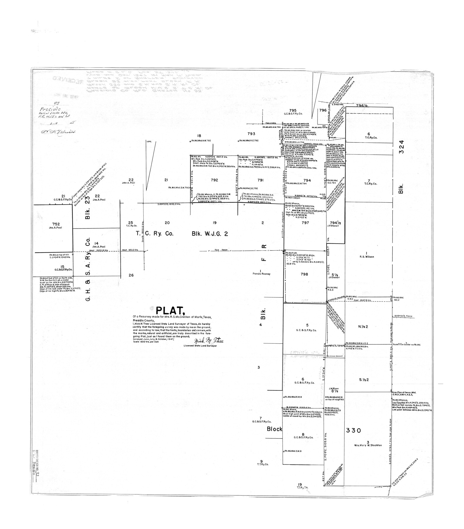
Presidio County Rolled Sketch 93
Plat of a resurvey made for Mrs. R.S. McCracken of Marfa, Texas, Presidio County
-
Map/Doc
7378
-
Collection
General Map Collection
-
Object Dates
1947 (Survey Date)
1948/2/9 (File Date)
-
People and Organizations
Nick M. Thee (Surveyor/Engineer)
-
Counties
Presidio
-
Subjects
Surveying Rolled Sketch
-
Height x Width
35.5 x 31.1 inches
90.2 x 79.0 cm
-
Scale
1" = 600 varas
Part of: General Map Collection
Rusk County Sketch File 11

Print $4.00
Rusk County Sketch File 11
1849
Size 8.5 x 9.1 inches
Map/Doc 35509
Aransas County Rolled Sketch 27B

Print $2.00
- Digital $50.00
Aransas County Rolled Sketch 27B
1958
Size 9.1 x 9.1 inches
Map/Doc 5057
Van Zandt County Working Sketch 6b

Print $40.00
- Digital $50.00
Van Zandt County Working Sketch 6b
1941
Size 54.7 x 43.5 inches
Map/Doc 72256
Flight Mission No. BRE-1P, Frame 113, Nueces County

Print $20.00
- Digital $50.00
Flight Mission No. BRE-1P, Frame 113, Nueces County
1956
Size 18.6 x 22.6 inches
Map/Doc 86679
Culberson County Working Sketch 76

Print $20.00
- Digital $50.00
Culberson County Working Sketch 76
1975
Size 33.4 x 43.1 inches
Map/Doc 68530
Bell County Sketch File 35

Print $40.00
- Digital $50.00
Bell County Sketch File 35
1952
Size 22.0 x 24.3 inches
Map/Doc 10918
Zavala County Rolled Sketch 27

Print $20.00
- Digital $50.00
Zavala County Rolled Sketch 27
1955
Size 21.2 x 20.0 inches
Map/Doc 8329
La Salle County Sketch File 8

Print $20.00
- Digital $50.00
La Salle County Sketch File 8
Size 27.2 x 19.3 inches
Map/Doc 11979
Kenedy County Rolled Sketch 3

Print $40.00
- Digital $50.00
Kenedy County Rolled Sketch 3
1904
Size 40.1 x 57.4 inches
Map/Doc 9329
[Maps of surveys in Reeves & Culberson Cos]
![61130, [Maps of surveys in Reeves & Culberson Cos], General Map Collection](https://historictexasmaps.com/wmedia_w700/maps/61130.tif.jpg)
Print $20.00
- Digital $50.00
[Maps of surveys in Reeves & Culberson Cos]
1937
Size 30.7 x 24.9 inches
Map/Doc 61130
Roberts County Working Sketch 11

Print $40.00
- Digital $50.00
Roberts County Working Sketch 11
1966
Size 57.6 x 38.6 inches
Map/Doc 63537
Dimmit County Sketch File 13

Print $46.00
- Digital $50.00
Dimmit County Sketch File 13
1884
Size 22.6 x 36.5 inches
Map/Doc 11341
You may also like

Map of America

Print $20.00
- Digital $50.00
Map of America
1841
Size 21.6 x 24.9 inches
Map/Doc 95150
Presidio County Working Sketch 107

Print $40.00
- Digital $50.00
Presidio County Working Sketch 107
1980
Size 36.0 x 57.3 inches
Map/Doc 71784
Trinity County Sketch File 34A

Print $6.00
- Digital $50.00
Trinity County Sketch File 34A
1921
Size 16.6 x 10.8 inches
Map/Doc 38578
The Rand-McNally New Commercial Atlas Map of Texas

Print $20.00
- Digital $50.00
The Rand-McNally New Commercial Atlas Map of Texas
Size 29.5 x 40.3 inches
Map/Doc 93993
Brewster County Sketch File N-27

Print $40.00
- Digital $50.00
Brewster County Sketch File N-27
Size 16.0 x 17.9 inches
Map/Doc 10972
Runnels County Working Sketch 13

Print $20.00
- Digital $50.00
Runnels County Working Sketch 13
1950
Size 19.4 x 17.8 inches
Map/Doc 63609
Pecos County Sketch File 30

Print $20.00
- Digital $50.00
Pecos County Sketch File 30
Size 28.9 x 22.0 inches
Map/Doc 12172
Flight Mission No. DQN-3K, Frame 4, Calhoun County

Print $20.00
- Digital $50.00
Flight Mission No. DQN-3K, Frame 4, Calhoun County
1953
Size 17.0 x 18.9 inches
Map/Doc 84336
Comal County Sketch File 9

Print $4.00
- Digital $50.00
Comal County Sketch File 9
1859
Size 13.6 x 8.5 inches
Map/Doc 19016
Wharton County Working Sketch 16

Print $20.00
- Digital $50.00
Wharton County Working Sketch 16
1952
Size 23.8 x 26.8 inches
Map/Doc 72480
[Gregg County League No. 2 Subdivided and vicinity]
![91566, [Gregg County League No. 2 Subdivided and vicinity], Twichell Survey Records](https://historictexasmaps.com/wmedia_w700/maps/91566-1.tif.jpg)
Print $20.00
- Digital $50.00
[Gregg County League No. 2 Subdivided and vicinity]
Size 17.7 x 16.1 inches
Map/Doc 91566