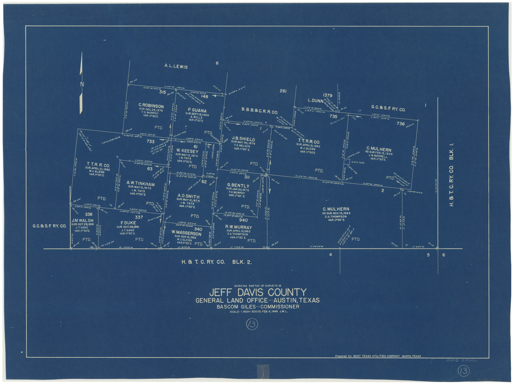
Jeff Davis County Working Sketch 13
-
Map/Doc
66508
-
Collection
General Map Collection
-
Object Dates
2/4/1949 (Creation Date)
-
Counties
Jeff Davis
-
Subjects
Surveying Working Sketch
-
Height x Width
24.5 x 32.7 inches
62.2 x 83.1 cm
-
Scale
1" = 300 varas
Part of: General Map Collection
United States - Gulf Coast Texas - Southern part of Laguna Madre

Print $20.00
- Digital $50.00
United States - Gulf Coast Texas - Southern part of Laguna Madre
1941
Size 26.4 x 18.2 inches
Map/Doc 72939

Duval County Working Sketch 22

Print $20.00
- Digital $50.00
Duval County Working Sketch 22
1942
Size 21.9 x 26.0 inches
Map/Doc 68746
Montague County Sketch File 12

Print $4.00
- Digital $50.00
Montague County Sketch File 12
Size 11.4 x 8.2 inches
Map/Doc 31736
Glasscock County Sketch File 26

Print $20.00
- Digital $50.00
Glasscock County Sketch File 26
1951
Size 16.1 x 28.3 inches
Map/Doc 11567
Stonewall County Working Sketch 32

Print $20.00
- Digital $50.00
Stonewall County Working Sketch 32
1983
Size 27.9 x 36.2 inches
Map/Doc 62339
Hill County Sketch File 21a

Print $4.00
- Digital $50.00
Hill County Sketch File 21a
1887
Size 10.8 x 8.4 inches
Map/Doc 26503
Outer Continental Shelf Leasing Maps (Texas Offshore Operations)

Print $20.00
- Digital $50.00
Outer Continental Shelf Leasing Maps (Texas Offshore Operations)
Size 24.3 x 18.5 inches
Map/Doc 75851
Kleberg County Rolled Sketch 10-19

Print $20.00
- Digital $50.00
Kleberg County Rolled Sketch 10-19
1952
Size 38.2 x 36.7 inches
Map/Doc 9379
Travis County Rolled Sketch 42

Print $20.00
- Digital $50.00
Travis County Rolled Sketch 42
Size 25.2 x 25.7 inches
Map/Doc 8040
Jefferson County Working Sketch 44

Print $20.00
- Digital $50.00
Jefferson County Working Sketch 44
1960
Size 42.4 x 36.4 inches
Map/Doc 73592
Brooks County Working Sketch 13

Print $20.00
- Digital $50.00
Brooks County Working Sketch 13
1943
Size 22.4 x 31.9 inches
Map/Doc 67797
You may also like
[Sketch showing area around Runnels County School Land, Yates survey 34 1/2 and Runnels County School Land]
![91683, [Sketch showing area around Runnels County School Land, Yates survey 34 1/2 and Runnels County School Land], Twichell Survey Records](https://historictexasmaps.com/wmedia_w700/maps/91683-1.tif.jpg)
Print $20.00
- Digital $50.00
[Sketch showing area around Runnels County School Land, Yates survey 34 1/2 and Runnels County School Land]
Size 17.5 x 12.5 inches
Map/Doc 91683
Flight Mission No. DCL-7C, Frame 143, Kenedy County

Print $20.00
- Digital $50.00
Flight Mission No. DCL-7C, Frame 143, Kenedy County
1943
Size 18.6 x 22.3 inches
Map/Doc 86100
Hockley County Sketch File 15

Print $6.00
- Digital $50.00
Hockley County Sketch File 15
1912
Size 11.4 x 8.9 inches
Map/Doc 26550
Map of the CB Live Stock Co. -N- Ranch situated in Crosby County, Texas

Print $20.00
- Digital $50.00
Map of the CB Live Stock Co. -N- Ranch situated in Crosby County, Texas
Size 21.2 x 38.1 inches
Map/Doc 90332
Val Verde County Working Sketch 111

Print $20.00
- Digital $50.00
Val Verde County Working Sketch 111
1990
Size 40.1 x 24.8 inches
Map/Doc 72246
Donley County Sketch File 6

Print $16.00
- Digital $50.00
Donley County Sketch File 6
1881
Size 12.9 x 8.5 inches
Map/Doc 21230
Travis County Working Sketch 37

Print $20.00
- Digital $50.00
Travis County Working Sketch 37
1968
Size 12.5 x 12.1 inches
Map/Doc 69421
Aransas County Sketch File 26

Print $28.00
- Digital $50.00
Aransas County Sketch File 26
1896
Size 5.2 x 4.7 inches
Map/Doc 13219
Montgomery County Sketch File 29

Print $8.00
- Digital $50.00
Montgomery County Sketch File 29
1932
Size 11.2 x 8.6 inches
Map/Doc 31884
Webb County Working Sketch 91

Print $40.00
- Digital $50.00
Webb County Working Sketch 91
1982
Size 37.1 x 49.7 inches
Map/Doc 72458
Gaines County Rolled Sketch 15C

Print $40.00
- Digital $50.00
Gaines County Rolled Sketch 15C
Size 128.4 x 22.8 inches
Map/Doc 75928
Harris County Sketch File 92

Print $20.00
- Digital $50.00
Harris County Sketch File 92
1932
Size 37.9 x 35.0 inches
Map/Doc 10483