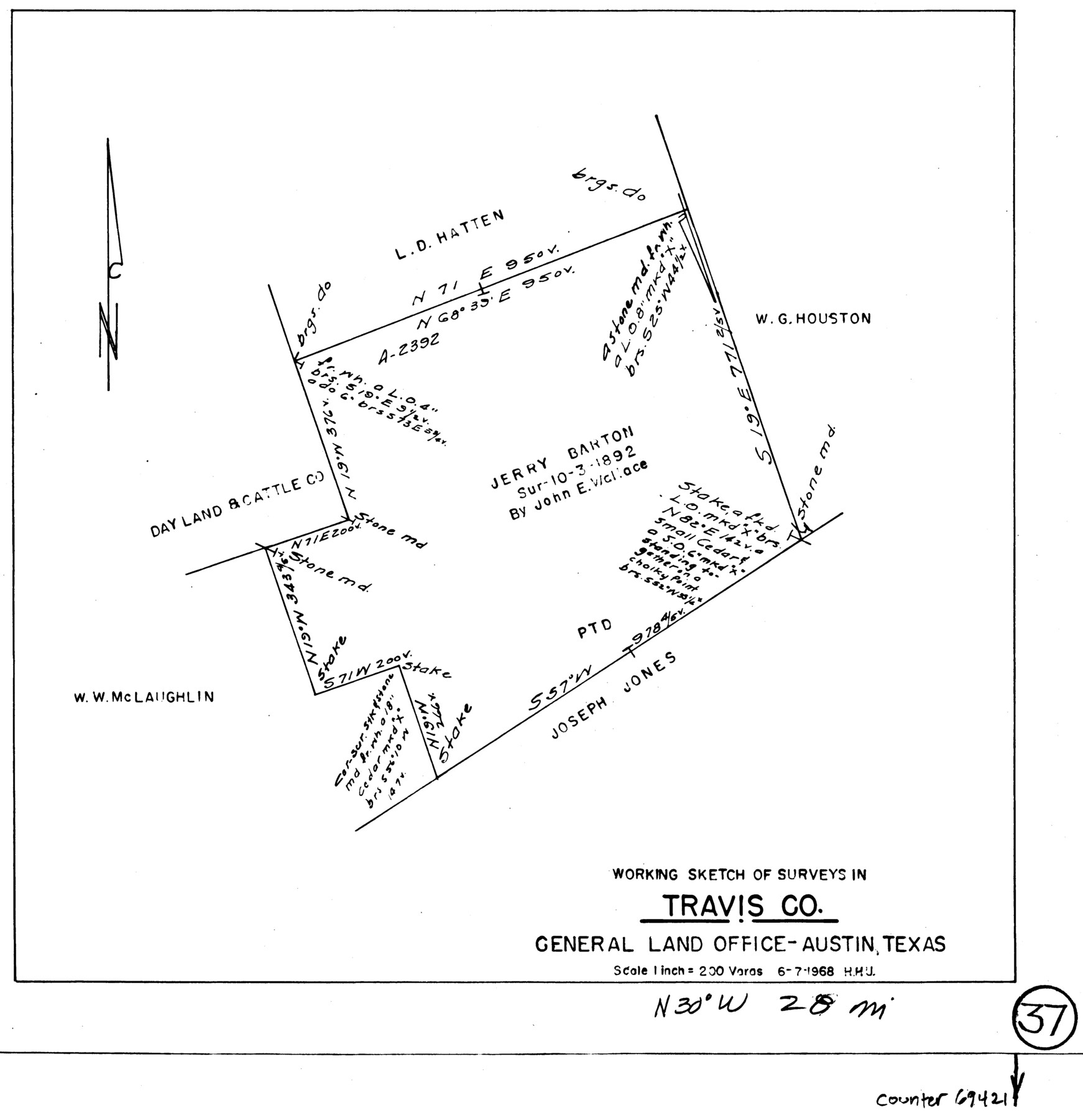
Travis County Working Sketch 37
-
Map/Doc
69421
-
Collection
General Map Collection
-
Object Dates
6/7/1968 (Creation Date)
-
People and Organizations
Herbert H. Ulbricht (Draftsman)
-
Counties
Travis
-
Subjects
Surveying Working Sketch
-
Height x Width
12.5 x 12.1 inches
31.8 x 30.7 cm
-
Scale
1" = 200 varas
Part of: General Map Collection
Jefferson County Working Sketch 34

Print $20.00
- Digital $50.00
Jefferson County Working Sketch 34
1981
Size 33.4 x 18.8 inches
Map/Doc 66578
Webb County Sketch File 13a

Print $20.00
- Digital $50.00
Webb County Sketch File 13a
1881
Size 19.0 x 25.7 inches
Map/Doc 12631
Gaines County Rolled Sketch 10

Print $20.00
- Digital $50.00
Gaines County Rolled Sketch 10
1905
Size 16.4 x 35.8 inches
Map/Doc 5930
Map of East Part of Pecos Co.

Print $20.00
- Digital $50.00
Map of East Part of Pecos Co.
1896
Size 47.4 x 37.6 inches
Map/Doc 66975
Red River County Sketch File 15

Print $4.00
- Digital $50.00
Red River County Sketch File 15
1863
Size 12.1 x 7.2 inches
Map/Doc 35137
Harris County Sketch File 61

Print $20.00
- Digital $50.00
Harris County Sketch File 61
1927
Size 19.4 x 16.7 inches
Map/Doc 11659
Wilbarger County Aerial Photograph Index Sheet 2

Print $20.00
- Digital $50.00
Wilbarger County Aerial Photograph Index Sheet 2
1950
Size 22.4 x 17.5 inches
Map/Doc 83751
Culberson County Working Sketch 75

Print $40.00
- Digital $50.00
Culberson County Working Sketch 75
1975
Size 48.1 x 32.8 inches
Map/Doc 68529
Segunda parte del Mapa, que comprende la Frontera, de los Dominios del Rey, en la America Septentrional

Print $40.00
- Digital $50.00
Segunda parte del Mapa, que comprende la Frontera, de los Dominios del Rey, en la America Septentrional
1769
Size 26.7 x 63.8 inches
Map/Doc 4667

Burnet County Boundary File 12a

Print $8.00
- Digital $50.00
Burnet County Boundary File 12a
Size 12.9 x 8.7 inches
Map/Doc 50956
Zapata County Rolled Sketch 26

Print $20.00
- Digital $50.00
Zapata County Rolled Sketch 26
1982
Size 43.0 x 30.7 inches
Map/Doc 8319
You may also like
Shelby County Working Sketch 13

Print $40.00
- Digital $50.00
Shelby County Working Sketch 13
1946
Size 52.0 x 33.7 inches
Map/Doc 63866
Live Oak County Sketch File 15

Print $4.00
- Digital $50.00
Live Oak County Sketch File 15
Size 12.6 x 8.1 inches
Map/Doc 30280
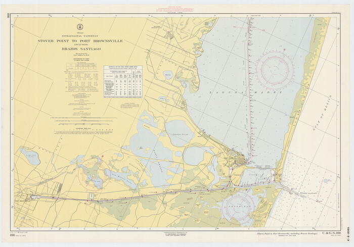
Texas Intracoastal Waterway - Stover Point to Port Brownsville including Brazos Santiago
Print $20.00
- Digital $50.00
Texas Intracoastal Waterway - Stover Point to Port Brownsville including Brazos Santiago
1961
Size 27.2 x 38.9 inches
Map/Doc 73519
Hutchinson County Working Sketch 3

Print $20.00
- Digital $50.00
Hutchinson County Working Sketch 3
Size 18.2 x 15.8 inches
Map/Doc 66361
Terrell County Rolled Sketch 26

Print $20.00
- Digital $50.00
Terrell County Rolled Sketch 26
1914
Size 17.3 x 15.2 inches
Map/Doc 7933
Hamilton Dam, Reservoir Clearing

Print $4.00
- Digital $50.00
Hamilton Dam, Reservoir Clearing
1936
Size 10.5 x 28.9 inches
Map/Doc 2096
Brewster County Sketch File N-26

Print $40.00
- Digital $50.00
Brewster County Sketch File N-26
Size 20.5 x 15.4 inches
Map/Doc 10971
Current Miscellaneous File 62

Print $64.00
- Digital $50.00
Current Miscellaneous File 62
Size 10.1 x 6.9 inches
Map/Doc 74068
Wilson County Working Sketch 2

Print $20.00
- Digital $50.00
Wilson County Working Sketch 2
1950
Size 42.0 x 42.8 inches
Map/Doc 72582
Houston County Sketch File 28

Print $20.00
- Digital $50.00
Houston County Sketch File 28
1877
Size 21.8 x 21.3 inches
Map/Doc 11789

Map of the Missouri, Kansas, & Texas Railway and Connecting Lines

Print $20.00
- Digital $50.00
Map of the Missouri, Kansas, & Texas Railway and Connecting Lines
Size 11.2 x 17.2 inches
Map/Doc 96599