Travis County Rolled Sketch 32A
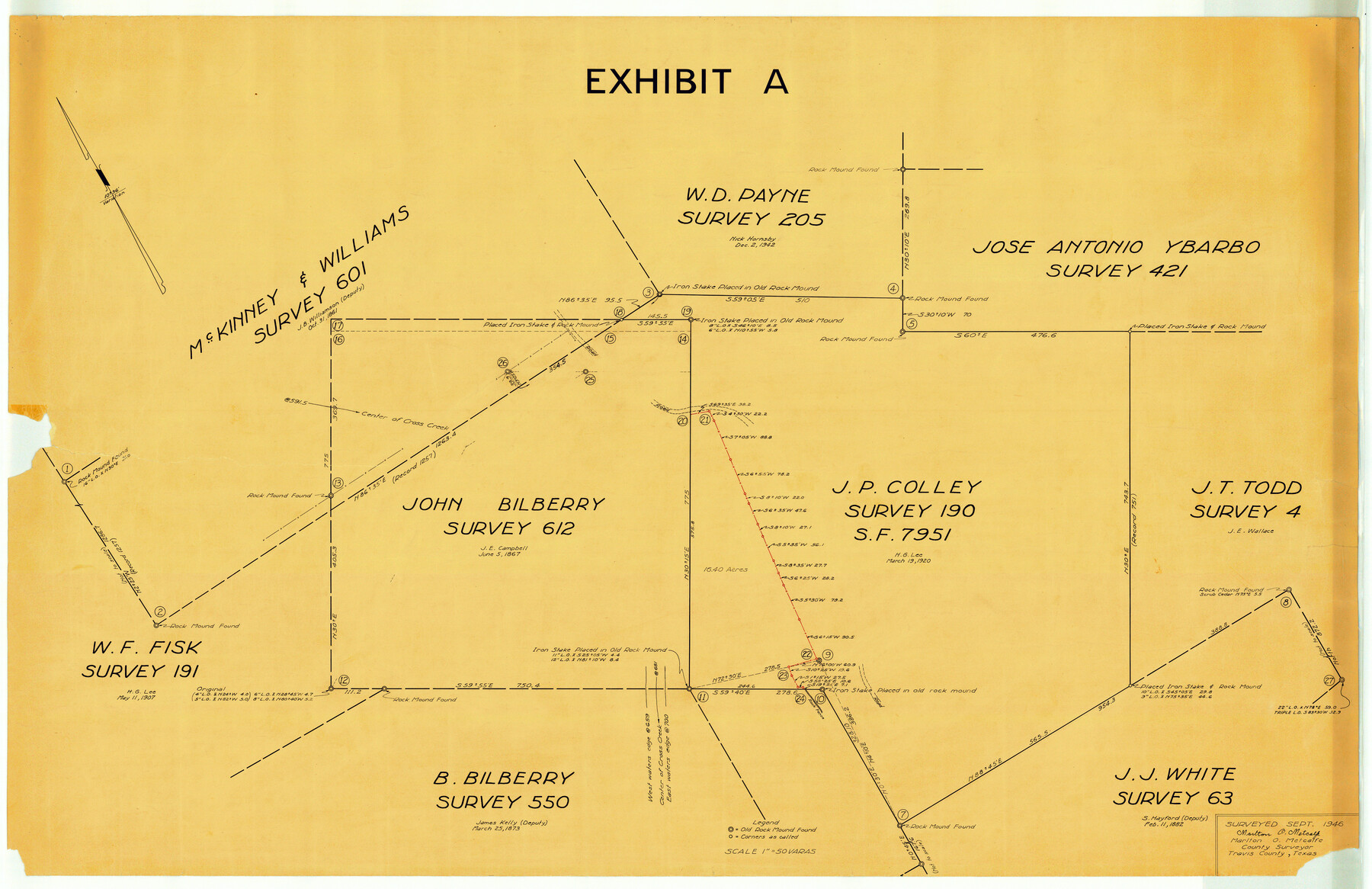
[Sketch showing John Bilberry survey 612 and J.P. Colley survey 190, SF-7951 and surrounding area]
-
Map/Doc
10013
-
Collection
General Map Collection
-
Object Dates
1946 (Survey Date)
1948/4/6 (File Date)
-
People and Organizations
Marlton O. Metcalfe (Surveyor/Engineer)
-
Counties
Travis
-
Subjects
Surveying Rolled Sketch
-
Height x Width
57.6 x 37.3 inches
146.3 x 94.7 cm
-
Medium
paper, manuscript
-
Comments
See Travis County Rolled Sketch 32B (10310) for related sketch.
Related maps
Travis County Rolled Sketch 32B

Print $20.00
- Digital $50.00
Travis County Rolled Sketch 32B
1948
Size 37.5 x 43.4 inches
Map/Doc 10310
Travis County Sketch File 58

Print $14.00
- Digital $50.00
Travis County Sketch File 58
1948
Size 11.4 x 8.9 inches
Map/Doc 38406
Travis County Sketch File 59

Print $28.00
- Digital $50.00
Travis County Sketch File 59
Size 14.4 x 9.0 inches
Map/Doc 38413
Part of: General Map Collection
Hall County Sketch File B2

Print $20.00
- Digital $50.00
Hall County Sketch File B2
1904
Size 21.7 x 35.1 inches
Map/Doc 11613
Andrews County Rolled Sketch 44

Print $40.00
- Digital $50.00
Andrews County Rolled Sketch 44
1990
Size 37.0 x 64.8 inches
Map/Doc 94990
Map of Gregg County

Print $20.00
- Digital $50.00
Map of Gregg County
1874
Size 14.0 x 13.9 inches
Map/Doc 3604
Presidio County Working Sketch 80

Print $20.00
- Digital $50.00
Presidio County Working Sketch 80
1967
Size 18.8 x 30.5 inches
Map/Doc 71757
McMullen County Sketch File 23

Print $4.00
- Digital $50.00
McMullen County Sketch File 23
1876
Size 10.0 x 8.0 inches
Map/Doc 31379
Nueces County Sketch File 82

Print $4.00
- Digital $50.00
Nueces County Sketch File 82
2000
Size 11.0 x 8.8 inches
Map/Doc 33165
Colorado County Working Sketch 32

Print $20.00
- Digital $50.00
Colorado County Working Sketch 32
1985
Size 42.7 x 36.8 inches
Map/Doc 68132
Potter County Working Sketch 6

Print $20.00
- Digital $50.00
Potter County Working Sketch 6
1959
Size 23.3 x 27.0 inches
Map/Doc 71666
Winkler County Working Sketch 16

Print $20.00
- Digital $50.00
Winkler County Working Sketch 16
1964
Size 27.7 x 35.8 inches
Map/Doc 72610
Limestone County Boundary File 59

Print $34.00
- Digital $50.00
Limestone County Boundary File 59
Size 7.4 x 8.7 inches
Map/Doc 56299

Flight Mission No. DQN-6K, Frame 88, Calhoun County

Print $20.00
- Digital $50.00
Flight Mission No. DQN-6K, Frame 88, Calhoun County
1953
Size 18.7 x 22.3 inches
Map/Doc 84448
You may also like
Burleson County Working Sketch 30

Print $20.00
- Digital $50.00
Burleson County Working Sketch 30
1981
Size 37.4 x 26.9 inches
Map/Doc 67749
General Highway Map, Oldham County, Texas

Print $20.00
General Highway Map, Oldham County, Texas
1961
Size 24.5 x 18.1 inches
Map/Doc 79619
Carte du Canada et de la Louisiane qui forment la Nouvelle France et des colonies angloises ou sont representez les pays contestez

Print $20.00
- Digital $50.00
Carte du Canada et de la Louisiane qui forment la Nouvelle France et des colonies angloises ou sont representez les pays contestez
1756
Size 21.5 x 29.6 inches
Map/Doc 97415
Hardeman County Sketch File 31

Print $4.00
- Digital $50.00
Hardeman County Sketch File 31
Size 14.5 x 9.0 inches
Map/Doc 25066
Fisher County Sketch File 4

Print $33.00
- Digital $50.00
Fisher County Sketch File 4
Size 11.4 x 9.2 inches
Map/Doc 22557
Burnet County Working Sketch 19

Print $20.00
- Digital $50.00
Burnet County Working Sketch 19
1982
Size 38.2 x 36.7 inches
Map/Doc 67862
Points of interest in and around Brownsville

Points of interest in and around Brownsville
1933
Map/Doc 96746

[T. & P. Blocks 33 and 34, Township 5N]
![90553, [T. & P. Blocks 33 and 34, Township 5N], Twichell Survey Records](https://historictexasmaps.com/wmedia_w700/maps/90553-1.tif.jpg)
Print $20.00
- Digital $50.00
[T. & P. Blocks 33 and 34, Township 5N]
Size 17.4 x 12.0 inches
Map/Doc 90553
Working Sketch in Travis County

Print $20.00
- Digital $50.00
Working Sketch in Travis County
1923
Size 15.4 x 18.6 inches
Map/Doc 91866
Current Miscellaneous File 6

Print $4.00
- Digital $50.00
Current Miscellaneous File 6
Size 11.3 x 8.8 inches
Map/Doc 73731
Little River, Faubion Bridge Sheet

Print $4.00
- Digital $50.00
Little River, Faubion Bridge Sheet
1914
Size 19.0 x 27.8 inches
Map/Doc 65060