Floyd County Sketch File 29
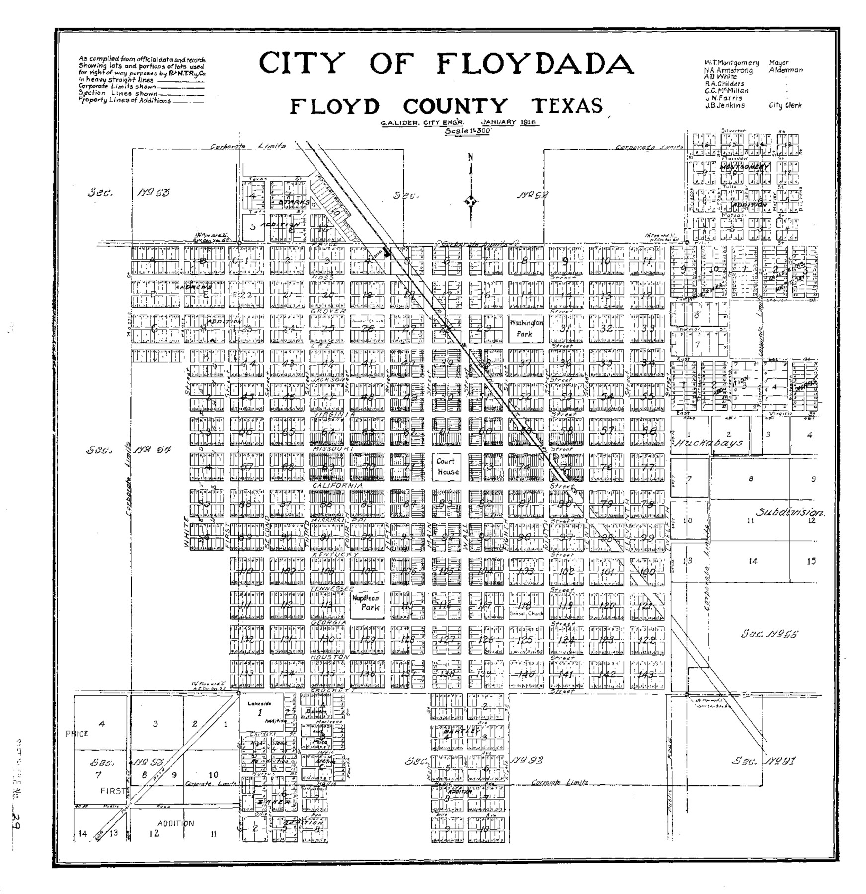
City of Floydada
-
Map/Doc
11488
-
Collection
General Map Collection
-
Object Dates
1922/3/7 (File Date)
-
People and Organizations
George A. Lider (Draftsman)
-
Counties
Floyd
-
Subjects
Surveying Sketch File
-
Height x Width
17.0 x 16.5 inches
43.2 x 41.9 cm
-
Medium
paper, print
-
Scale
1:300
-
Features
Fifth Street
Ollie Avenue
Public Road
Garrison Street
Leonard Street
Ennis Street
Fourth Street
White Street
First Street
Second Street
Third Street
Hailie Avenue
Main Street
Wall Street
Eighth Street
Ninth Street
Tenth Street
Eleventh Street
P&NT
Twelfth Street
East Virginia Street
Missouri Street
Plainview Street
Mataosi Street
Price Street
Ross Street
Grover Street
Lee Street
Jackson Street
Virginia Street
Washington Park
Silverton Street
California Street
Kentucky Street
Tennessee Street
George Street
Houston Street
Crockett Street
Napoleon Park
Marigaro Avenue
Jeffio Avenue
Part of: General Map Collection
Bee County Sketch File 28

Print $6.00
- Digital $50.00
Bee County Sketch File 28
Size 14.4 x 8.7 inches
Map/Doc 14335
Montgomery County Working Sketch 8a

Print $20.00
- Digital $50.00
Montgomery County Working Sketch 8a
1932
Size 17.8 x 20.4 inches
Map/Doc 71114
Military Reconnaissance of the Arkansas Rio Del Norte and Rio Gila

Print $40.00
- Digital $50.00
Military Reconnaissance of the Arkansas Rio Del Norte and Rio Gila
1847
Size 33.0 x 72.2 inches
Map/Doc 552
Eastland County Working Sketch 17

Print $20.00
- Digital $50.00
Eastland County Working Sketch 17
1919
Size 18.3 x 16.2 inches
Map/Doc 68798
Clason's Oil Map of Texas and Oklahoma showing the location and approximate area of the oil and gas fields

Print $20.00
- Digital $50.00
Clason's Oil Map of Texas and Oklahoma showing the location and approximate area of the oil and gas fields
1919
Size 22.4 x 24.5 inches
Map/Doc 97158
Upton County Sketch File 31

Print $20.00
- Digital $50.00
Upton County Sketch File 31
Size 5.8 x 20.7 inches
Map/Doc 38883
Crockett County Working Sketch 58

Print $40.00
- Digital $50.00
Crockett County Working Sketch 58
1954
Size 24.3 x 54.4 inches
Map/Doc 68391
Val Verde County Working Sketch 3

Print $20.00
- Digital $50.00
Val Verde County Working Sketch 3
Size 17.5 x 24.1 inches
Map/Doc 72138
Val Verde County Rolled Sketch 39

Print $20.00
- Digital $50.00
Val Verde County Rolled Sketch 39
Size 21.7 x 33.9 inches
Map/Doc 8115
Winkler County Rolled Sketch 14

Print $20.00
- Digital $50.00
Winkler County Rolled Sketch 14
Size 25.9 x 38.4 inches
Map/Doc 8275
Upton County Rolled Sketch 16

Print $20.00
- Digital $50.00
Upton County Rolled Sketch 16
1927
Size 18.9 x 37.7 inches
Map/Doc 8071
Donley County Sketch File 26

Print $6.00
- Digital $50.00
Donley County Sketch File 26
Size 12.8 x 8.3 inches
Map/Doc 21261
You may also like
Rusk County Sketch File 6

Print $4.00
Rusk County Sketch File 6
1848
Size 6.3 x 7.9 inches
Map/Doc 35499
In the Supreme Court of the United States, The State of Oklahoma, Complainant vs. The State of Texas, Defendant, The United States of America, Intervener, Red River Valley, Texas and Oklahoma Between the 98th and 100th Meridians in Five Sheets, 1921

Print $40.00
- Digital $50.00
In the Supreme Court of the United States, The State of Oklahoma, Complainant vs. The State of Texas, Defendant, The United States of America, Intervener, Red River Valley, Texas and Oklahoma Between the 98th and 100th Meridians in Five Sheets, 1921
1921
Size 37.2 x 59.5 inches
Map/Doc 75274
Robertson County Rolled Sketch 2

Print $43.00
- Digital $50.00
Robertson County Rolled Sketch 2
1974
Size 9.6 x 15.1 inches
Map/Doc 48861
Jack County Working Sketch 20

Print $20.00
- Digital $50.00
Jack County Working Sketch 20
1991
Size 35.4 x 28.9 inches
Map/Doc 66446
Map of Matagorda County, Texas

Print $20.00
Map of Matagorda County, Texas
1879
Size 30.7 x 27.4 inches
Map/Doc 88978
Current Miscellaneous File 44

Print $10.00
- Digital $50.00
Current Miscellaneous File 44
1954
Size 11.3 x 8.8 inches
Map/Doc 73985
El Paso County Working Sketch 57

Print $20.00
- Digital $50.00
El Paso County Working Sketch 57
Size 37.5 x 37.4 inches
Map/Doc 69079
Medina County Sketch File 1

Print $4.00
- Digital $50.00
Medina County Sketch File 1
Size 12.5 x 8.1 inches
Map/Doc 31437
Culberson County Working Sketch 47

Print $20.00
- Digital $50.00
Culberson County Working Sketch 47
1971
Size 25.7 x 36.5 inches
Map/Doc 68501
Flight Mission No. BRA-6M, Frame 96, Jefferson County

Print $20.00
- Digital $50.00
Flight Mission No. BRA-6M, Frame 96, Jefferson County
1953
Size 18.5 x 22.3 inches
Map/Doc 85439
Matagorda Bay Including Lavaca and Tres Palacios Bays

Print $20.00
- Digital $50.00
Matagorda Bay Including Lavaca and Tres Palacios Bays
1975
Size 37.2 x 47.7 inches
Map/Doc 73364
Nacogdoches County Working Sketch 7

Print $20.00
- Digital $50.00
Nacogdoches County Working Sketch 7
1962
Size 24.1 x 21.7 inches
Map/Doc 71223