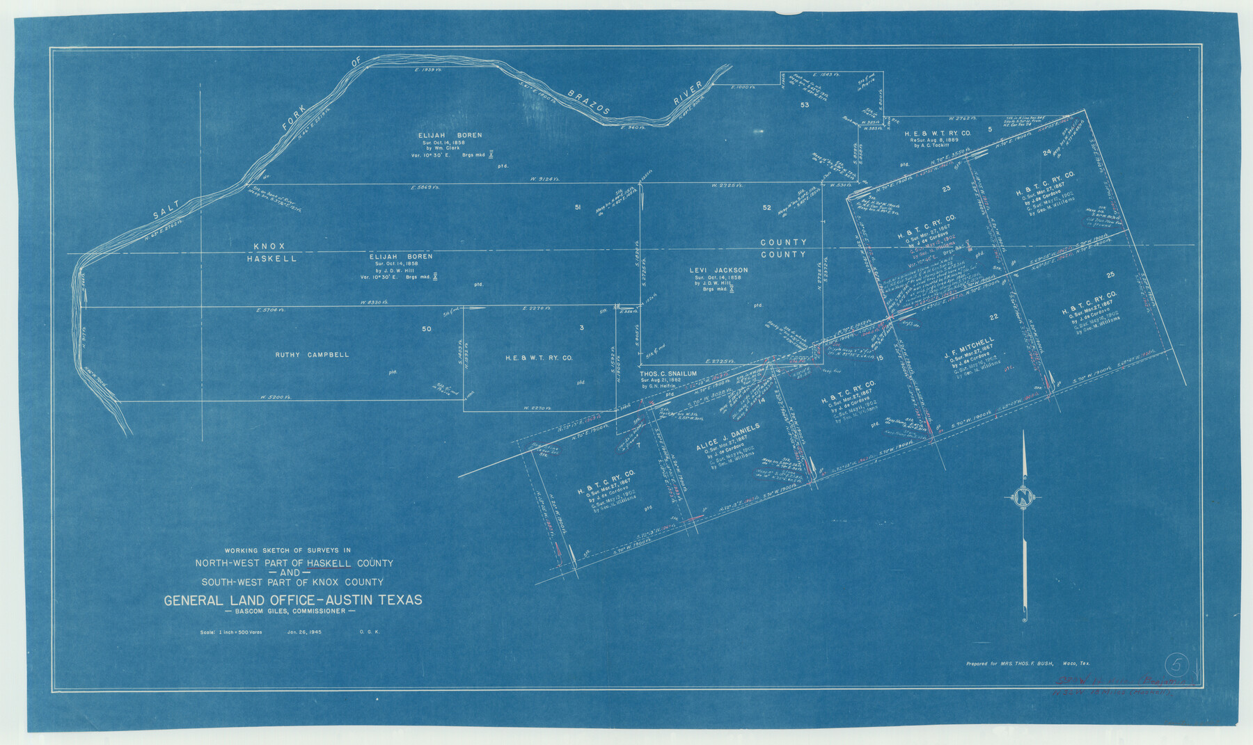
Haskell County Working Sketch 5
-
Map/Doc
66063
-
Collection
General Map Collection
-
Object Dates
1/26/1945 (Creation Date)
-
People and Organizations
Otto G. Kurio (Draftsman)
-
Counties
Haskell Knox
-
Subjects
Surveying Working Sketch
-
Height x Width
22.2 x 37.2 inches
56.4 x 94.5 cm
-
Scale
1" = 500 varas
Part of: General Map Collection
Jefferson County Rolled Sketch 41

Print $20.00
- Digital $50.00
Jefferson County Rolled Sketch 41
1897
Size 17.6 x 25.4 inches
Map/Doc 6400
Hutchinson County Working Sketch 16

Print $20.00
- Digital $50.00
Hutchinson County Working Sketch 16
1953
Size 23.0 x 36.3 inches
Map/Doc 66374
West Part El Paso Co.

Print $20.00
- Digital $50.00
West Part El Paso Co.
1908
Size 46.8 x 42.4 inches
Map/Doc 4713
El Paso County Boundary File 4

Print $12.00
- Digital $50.00
El Paso County Boundary File 4
Size 13.5 x 8.6 inches
Map/Doc 53038
Aransas County Sketch File 33

Print $34.00
- Digital $50.00
Aransas County Sketch File 33
1919
Size 14.4 x 8.8 inches
Map/Doc 13303
Hamilton County Working Sketch 31

Print $20.00
- Digital $50.00
Hamilton County Working Sketch 31
Size 23.3 x 18.2 inches
Map/Doc 63369
Jackson County Sketch File 4

Print $20.00
- Digital $50.00
Jackson County Sketch File 4
Size 18.2 x 22.7 inches
Map/Doc 11834
Presidio County Sketch File 109

Print $6.00
- Digital $50.00
Presidio County Sketch File 109
Size 9.0 x 6.1 inches
Map/Doc 34815
Flight Mission No. DCL-4C, Frame 65, Kenedy County

Print $20.00
- Digital $50.00
Flight Mission No. DCL-4C, Frame 65, Kenedy County
1943
Size 18.5 x 22.3 inches
Map/Doc 85810
Nueces County Rolled Sketch 124

Print $20.00
- Digital $50.00
Nueces County Rolled Sketch 124
1997
Size 23.7 x 36.8 inches
Map/Doc 7159
Duval County Rolled Sketch 33B

Digital $50.00
Duval County Rolled Sketch 33B
Size 42.5 x 76.2 inches
Map/Doc 8819
Cooke County Sketch File 31

Print $22.00
- Digital $50.00
Cooke County Sketch File 31
1873
Size 8.0 x 12.9 inches
Map/Doc 19293
You may also like
G.C. & S.F. Ry. Main Line, Texas, Right of Way Map, Keeler to Haslet

Print $40.00
- Digital $50.00
G.C. & S.F. Ry. Main Line, Texas, Right of Way Map, Keeler to Haslet
1916
Size 25.1 x 122.6 inches
Map/Doc 64545
A New Map of Texas

Print $20.00
- Digital $50.00
A New Map of Texas
1841
Size 17.6 x 16.2 inches
Map/Doc 93862
Yoakum County Sketch File 16

Print $20.00
- Digital $50.00
Yoakum County Sketch File 16
1939
Size 15.0 x 19.4 inches
Map/Doc 12709
Crane County Rolled Sketch 18

Print $20.00
- Digital $50.00
Crane County Rolled Sketch 18
1950
Size 37.8 x 37.2 inches
Map/Doc 8683
Floyd County Sketch File 4

Print $48.00
- Digital $50.00
Floyd County Sketch File 4
1886
Size 15.4 x 13.9 inches
Map/Doc 22690
Starr County Rolled Sketch X

Print $121.00
- Digital $50.00
Starr County Rolled Sketch X
Size 13.3 x 8.1 inches
Map/Doc 75961
La Salle County Working Sketch 44

Print $40.00
- Digital $50.00
La Salle County Working Sketch 44
1980
Size 34.7 x 65.8 inches
Map/Doc 70345
[Blocks Surrounding I. G. Yates Section 34 1/2]
![92442, [Blocks Surrounding I. G. Yates Section 34 1/2], Twichell Survey Records](https://historictexasmaps.com/wmedia_w700/maps/92442-1.tif.jpg)
Print $20.00
- Digital $50.00
[Blocks Surrounding I. G. Yates Section 34 1/2]
Size 41.9 x 11.3 inches
Map/Doc 92442
Crosby County Sketch File 11b

Print $20.00
- Digital $50.00
Crosby County Sketch File 11b
1890
Size 17.2 x 15.6 inches
Map/Doc 11247
From Citizens of Nacogdoches County to Redefine the Boundaries of Nacogdoches County, December 2, 1841

Print $20.00
From Citizens of Nacogdoches County to Redefine the Boundaries of Nacogdoches County, December 2, 1841
2020
Size 22.5 x 21.7 inches
Map/Doc 96395

Uvalde County Working Sketch 8

Print $20.00
- Digital $50.00
Uvalde County Working Sketch 8
1942
Size 37.4 x 23.6 inches
Map/Doc 72078