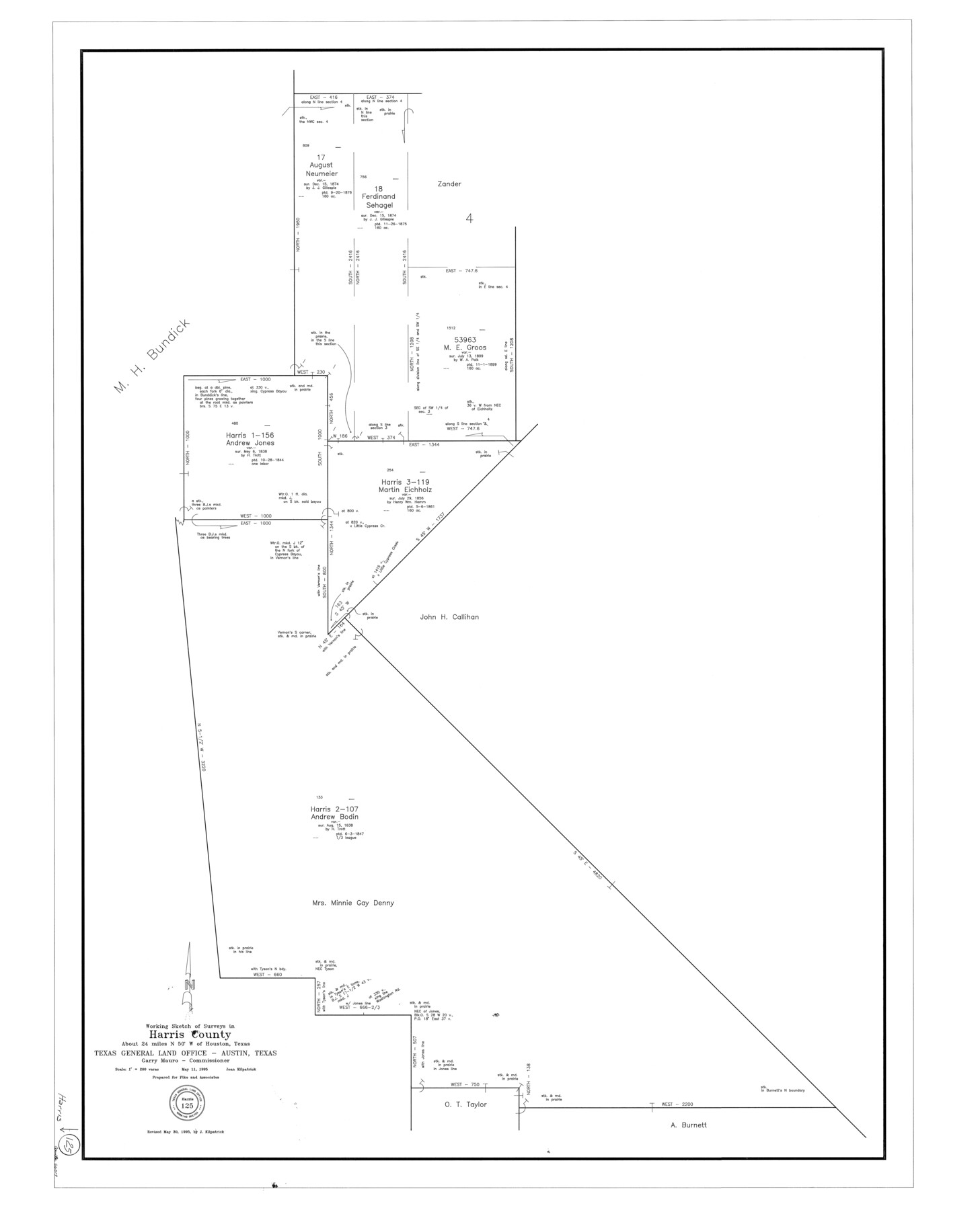
Harris County Working Sketch 125
-
Map/Doc
66017
-
Collection
General Map Collection
-
Object Dates
5/11/1995 (Creation Date)
5/30/1995 (Revision Date)
-
People and Organizations
Joan Kilpatrick (Draftsman)
-
Counties
Harris
-
Subjects
Surveying Working Sketch
-
Height x Width
42.0 x 34.0 inches
106.7 x 86.4 cm
-
Scale
1" = 200 varas
Part of: General Map Collection
Randall County Working Sketch 1

Print $20.00
- Digital $50.00
Randall County Working Sketch 1
1974
Size 28.0 x 31.6 inches
Map/Doc 71838
Freestone County Working Sketch 24

Print $20.00
- Digital $50.00
Freestone County Working Sketch 24
1982
Size 24.5 x 25.3 inches
Map/Doc 69266
Flight Mission No. DAG-18K, Frame 189, Matagorda County

Print $20.00
- Digital $50.00
Flight Mission No. DAG-18K, Frame 189, Matagorda County
1952
Size 18.5 x 22.3 inches
Map/Doc 86381
Menard County Sketch File 27

Print $8.00
- Digital $50.00
Menard County Sketch File 27
1943
Size 11.2 x 8.8 inches
Map/Doc 31564
Newton County Boundary File 1

Print $4.00
- Digital $50.00
Newton County Boundary File 1
Size 14.3 x 8.8 inches
Map/Doc 57614
Austin County Sketch File 6a

Print $14.00
- Digital $50.00
Austin County Sketch File 6a
1895
Size 11.2 x 8.6 inches
Map/Doc 13865
Colorado County Working Sketch 29

Print $20.00
- Digital $50.00
Colorado County Working Sketch 29
1980
Size 15.4 x 12.4 inches
Map/Doc 68129
Presidio County Sketch File 49

Print $6.00
- Digital $50.00
Presidio County Sketch File 49
1919
Size 14.6 x 11.9 inches
Map/Doc 34584
Pecos County Rolled Sketch 189

Print $20.00
- Digital $50.00
Pecos County Rolled Sketch 189
1998
Size 22.2 x 33.7 inches
Map/Doc 7307
Tourist Map of San Antonio showing points of interest, places of amusements, main thoroughfares and highways in and out of city and where they go

Print $20.00
- Digital $50.00
Tourist Map of San Antonio showing points of interest, places of amusements, main thoroughfares and highways in and out of city and where they go
Size 22.2 x 15.3 inches
Map/Doc 95956
Potter County Rolled Sketch 9

Print $20.00
- Digital $50.00
Potter County Rolled Sketch 9
1931
Size 36.7 x 25.3 inches
Map/Doc 7322
Victoria County Working Sketch 1

Print $20.00
- Digital $50.00
Victoria County Working Sketch 1
1938
Size 33.5 x 36.9 inches
Map/Doc 72271
You may also like
Gonzales County Working Sketch Graphic Index

Print $40.00
- Digital $50.00
Gonzales County Working Sketch Graphic Index
1986
Size 40.2 x 53.0 inches
Map/Doc 76556
[Metropolitan Areas of Texas]
![96824, [Metropolitan Areas of Texas], General Map Collection](https://historictexasmaps.com/wmedia_w700/maps/96824.tif.jpg)
[Metropolitan Areas of Texas]
1994
Size 33.6 x 36.1 inches
Map/Doc 96824
Bexar County Sketch File 44

Print $5.00
- Digital $50.00
Bexar County Sketch File 44
1844
Size 15.7 x 9.3 inches
Map/Doc 14524
Flight Mission No. BRA-7M, Frame 198, Jefferson County

Print $20.00
- Digital $50.00
Flight Mission No. BRA-7M, Frame 198, Jefferson County
1953
Size 18.7 x 22.4 inches
Map/Doc 85566
Stephens County Working Sketch 34

Print $20.00
- Digital $50.00
Stephens County Working Sketch 34
1978
Size 33.5 x 28.3 inches
Map/Doc 63977
Pecos County Rolled Sketch 30

Print $20.00
- Digital $50.00
Pecos County Rolled Sketch 30
1890
Size 39.2 x 30.7 inches
Map/Doc 9691
Pecos County Working Sketch 57

Print $20.00
- Digital $50.00
Pecos County Working Sketch 57
1949
Size 24.2 x 26.4 inches
Map/Doc 71529
Smith County Working Sketch Graphic Index

Print $20.00
- Digital $50.00
Smith County Working Sketch Graphic Index
1948
Size 44.7 x 41.1 inches
Map/Doc 76699
Flight Mission No. DIX-6P, Frame 127, Aransas County

Print $20.00
- Digital $50.00
Flight Mission No. DIX-6P, Frame 127, Aransas County
1956
Size 19.1 x 23.0 inches
Map/Doc 83833
Van Zandt County Sketch File 16

Print $4.00
- Digital $50.00
Van Zandt County Sketch File 16
1858
Size 6.8 x 8.0 inches
Map/Doc 39410
Harris County Rolled Sketch 98

Print $20.00
- Digital $50.00
Harris County Rolled Sketch 98
1992
Size 27.1 x 39.5 inches
Map/Doc 6136
Frio County Working Sketch 11

Print $20.00
- Digital $50.00
Frio County Working Sketch 11
1952
Size 22.9 x 20.0 inches
Map/Doc 69285