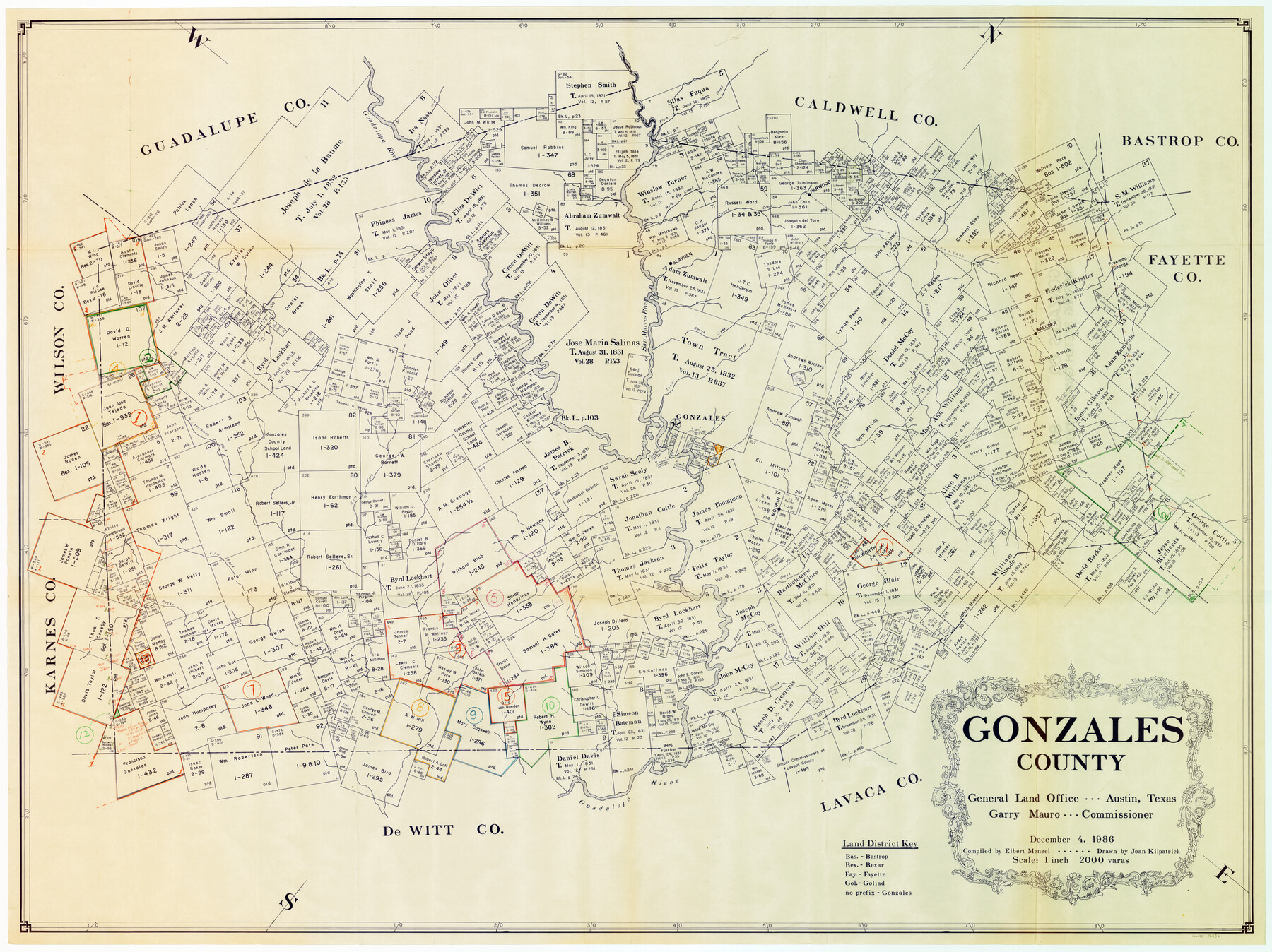
Gonzales County Working Sketch Graphic Index
-
Map/Doc
76556
-
Collection
General Map Collection
-
Object Dates
12/4/1986 (Creation Date)
-
People and Organizations
Elbert Menzel (Compiler)
Joan Kilpatrick (Draftsman)
-
Counties
Gonzales
-
Subjects
County Surveying Working Sketch
-
Height x Width
40.2 x 53.0 inches
102.1 x 134.6 cm
-
Scale
1" = 2000 varas
-
Comments
Please note that Gonzales County Working Sketch 6 is missing and therefore no longer available.
Part of: General Map Collection
Dallas County Working Sketch 15

Print $20.00
- Digital $50.00
Dallas County Working Sketch 15
1980
Size 14.3 x 11.4 inches
Map/Doc 68581
Right of Way & Track Map, San Antonio & Aransas Pass Railway Co.

Print $40.00
- Digital $50.00
Right of Way & Track Map, San Antonio & Aransas Pass Railway Co.
1919
Size 25.3 x 56.4 inches
Map/Doc 64217
Leon County Rolled Sketch 30

Print $20.00
- Digital $50.00
Leon County Rolled Sketch 30
Size 30.9 x 25.7 inches
Map/Doc 6613
Hill County Boundary File 45

Print $41.00
- Digital $50.00
Hill County Boundary File 45
Size 9.0 x 3.6 inches
Map/Doc 54743
Flight Mission No. CGI-4N, Frame 159, Cameron County

Print $20.00
- Digital $50.00
Flight Mission No. CGI-4N, Frame 159, Cameron County
1955
Size 18.7 x 22.2 inches
Map/Doc 84667
Flight Mission No. BRE-2P, Frame 26, Nueces County

Print $20.00
- Digital $50.00
Flight Mission No. BRE-2P, Frame 26, Nueces County
1956
Size 18.6 x 22.7 inches
Map/Doc 86735
Map of Eastland Co.

Print $20.00
- Digital $50.00
Map of Eastland Co.
1896
Size 40.0 x 42.8 inches
Map/Doc 78411

Rusk County Working Sketch 32

Print $20.00
- Digital $50.00
Rusk County Working Sketch 32
1919
Size 16.7 x 17.1 inches
Map/Doc 63669
North Part Brewster Co.

Print $40.00
- Digital $50.00
North Part Brewster Co.
1914
Size 40.4 x 49.3 inches
Map/Doc 66732
Fannin County Working Sketch 10

Print $20.00
- Digital $50.00
Fannin County Working Sketch 10
1989
Size 26.5 x 38.0 inches
Map/Doc 69164
Stonewall County Sketch File AA1

Print $26.00
- Digital $50.00
Stonewall County Sketch File AA1
1916
Size 14.3 x 8.6 inches
Map/Doc 37288
You may also like
Limestone County Sketch File 16

Print $4.00
- Digital $50.00
Limestone County Sketch File 16
Size 12.8 x 8.3 inches
Map/Doc 30185
Flight Mission No. BRE-1P, Frame 72, Nueces County

Print $20.00
- Digital $50.00
Flight Mission No. BRE-1P, Frame 72, Nueces County
1956
Size 18.4 x 22.3 inches
Map/Doc 86654
Dawson County Working Sketch 22

Print $20.00
- Digital $50.00
Dawson County Working Sketch 22
1989
Size 26.2 x 20.5 inches
Map/Doc 68566
Leon County Sketch File 11a

Print $4.00
- Digital $50.00
Leon County Sketch File 11a
Size 9.7 x 8.7 inches
Map/Doc 29763
Reagan County Sketch File 24

Print $6.00
- Digital $50.00
Reagan County Sketch File 24
1940
Size 11.4 x 8.7 inches
Map/Doc 35018
Sterling County Rolled Sketch 12

Print $20.00
- Digital $50.00
Sterling County Rolled Sketch 12
1941
Size 35.6 x 35.0 inches
Map/Doc 9946
Kinney County Working Sketch 54

Print $20.00
- Digital $50.00
Kinney County Working Sketch 54
1981
Size 40.0 x 32.8 inches
Map/Doc 70236
Flight Mission No. DQN-2K, Frame 37, Calhoun County

Print $20.00
- Digital $50.00
Flight Mission No. DQN-2K, Frame 37, Calhoun County
1953
Size 18.4 x 22.2 inches
Map/Doc 84242
Plan of the City of Austin

Print $20.00
Plan of the City of Austin
1839
Size 24.2 x 19.4 inches
Map/Doc 76204
Clay County Rolled Sketch 4A

Print $20.00
- Digital $50.00
Clay County Rolled Sketch 4A
1949
Size 22.0 x 24.0 inches
Map/Doc 5498
United States - Gulf Coast Texas - Southern part of Laguna Madre

Print $20.00
- Digital $50.00
United States - Gulf Coast Texas - Southern part of Laguna Madre
1941
Size 26.4 x 18.2 inches
Map/Doc 72945
Sterling County Rolled Sketch 10

Print $20.00
- Digital $50.00
Sterling County Rolled Sketch 10
1939
Size 24.2 x 31.2 inches
Map/Doc 7846