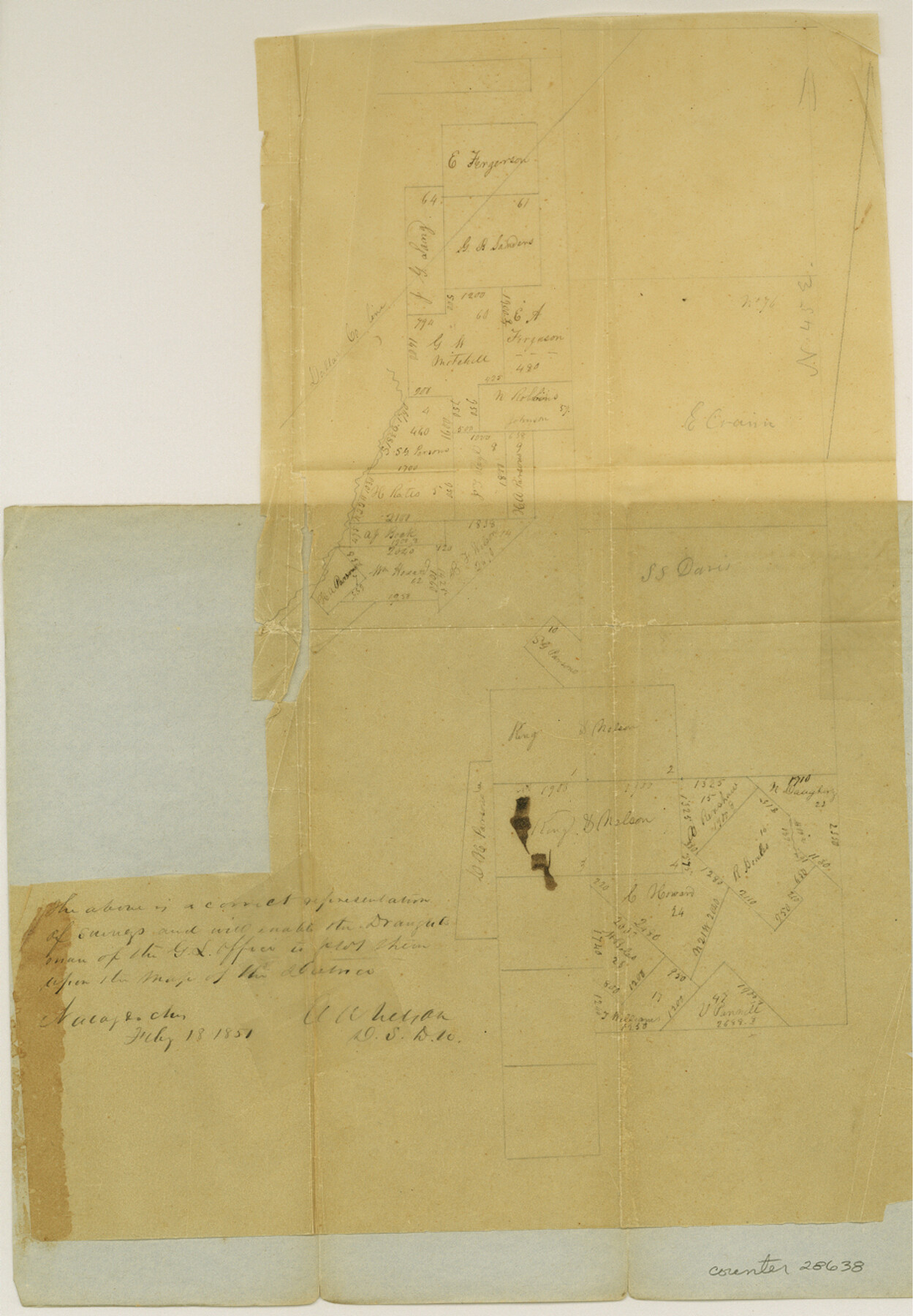
Kaufman County Sketch File 8
[Sketch in the southwest part of the county]
-
Map/Doc
28638
-
Collection
General Map Collection
-
Object Dates
2/18/1851 (Creation Date)
4/27/1851 (File Date)
-
People and Organizations
A.A. Nelson (Surveyor/Engineer)
-
Counties
Kaufman Dallas
-
Subjects
Surveying Sketch File
-
Height x Width
13.3 x 9.2 inches
33.8 x 23.4 cm
-
Medium
paper, manuscript
Part of: General Map Collection
Andrews County Working Sketch 31

Print $20.00
- Digital $50.00
Andrews County Working Sketch 31
1990
Size 42.9 x 30.0 inches
Map/Doc 67077
Right of Way and Track Map, Galveston, Harrisburg & San Antonio Ry. operated by the T. & N. O. R.R. Co., Victoria Division, Rosenberg to Beeville

Print $40.00
- Digital $50.00
Right of Way and Track Map, Galveston, Harrisburg & San Antonio Ry. operated by the T. & N. O. R.R. Co., Victoria Division, Rosenberg to Beeville
1918
Size 24.8 x 56.4 inches
Map/Doc 76164
Webb County Working Sketch 85

Print $20.00
- Digital $50.00
Webb County Working Sketch 85
1981
Size 21.1 x 29.0 inches
Map/Doc 72452
Galveston County Sketch File 66

Print $116.00
- Digital $50.00
Galveston County Sketch File 66
Size 5.0 x 10.0 inches
Map/Doc 23751
Gregg County Rolled Sketch 21

Print $20.00
- Digital $50.00
Gregg County Rolled Sketch 21
1957
Size 34.4 x 40.4 inches
Map/Doc 10650
Zavala County Working Sketch 6

Print $20.00
- Digital $50.00
Zavala County Working Sketch 6
1942
Size 30.8 x 26.5 inches
Map/Doc 62081
Refugio County Working Sketch 11

Print $20.00
- Digital $50.00
Refugio County Working Sketch 11
1942
Size 40.9 x 38.3 inches
Map/Doc 63520
Coleman County Sketch File 35

Print $2.00
- Digital $50.00
Coleman County Sketch File 35
Size 8.4 x 8.2 inches
Map/Doc 18740
Hardin County Working Sketch 7

Print $20.00
- Digital $50.00
Hardin County Working Sketch 7
1925
Size 23.3 x 12.6 inches
Map/Doc 63405
Childress County Rolled Sketch 1

Print $20.00
- Digital $50.00
Childress County Rolled Sketch 1
Size 31.2 x 26.5 inches
Map/Doc 5437
Old Miscellaneous File 26

Print $4.00
- Digital $50.00
Old Miscellaneous File 26
Size 14.3 x 9.0 inches
Map/Doc 75634
Hale County Boundary File 6

Print $40.00
- Digital $50.00
Hale County Boundary File 6
Size 37.9 x 6.8 inches
Map/Doc 54073
You may also like
Young County Working Sketch 10

Print $20.00
- Digital $50.00
Young County Working Sketch 10
1921
Size 24.4 x 34.4 inches
Map/Doc 62033
General Highway Map. Detail of Cities and Towns in Hale County, Texas [Plainview and vicinity]
![79109, General Highway Map. Detail of Cities and Towns in Hale County, Texas [Plainview and vicinity], Texas State Library and Archives](https://historictexasmaps.com/wmedia_w700/maps/79109.tif.jpg)
Print $20.00
General Highway Map. Detail of Cities and Towns in Hale County, Texas [Plainview and vicinity]
1940
Size 25.0 x 18.5 inches
Map/Doc 79109
Leon River, Magnum Sheet/South Fork Leon River

Print $6.00
- Digital $50.00
Leon River, Magnum Sheet/South Fork Leon River
1937
Size 30.5 x 34.8 inches
Map/Doc 65068
Flight Mission No. DAG-21K, Frame 87, Matagorda County

Print $20.00
- Digital $50.00
Flight Mission No. DAG-21K, Frame 87, Matagorda County
1952
Size 18.5 x 22.4 inches
Map/Doc 86416
Ector County Boundary File 4

Print $4.00
- Digital $50.00
Ector County Boundary File 4
Size 13.3 x 8.2 inches
Map/Doc 52845
Texas City Channel, Texas, Channel and Turning Basin Dredging - Sheet 2

Print $20.00
- Digital $50.00
Texas City Channel, Texas, Channel and Turning Basin Dredging - Sheet 2
1958
Size 28.6 x 41.0 inches
Map/Doc 61832
Ownership Map SE 1/4 Lubbock County

Print $20.00
- Digital $50.00
Ownership Map SE 1/4 Lubbock County
Size 37.2 x 36.4 inches
Map/Doc 89895
Flight Mission No. CGI-1N, Frame 219, Cameron County

Print $20.00
- Digital $50.00
Flight Mission No. CGI-1N, Frame 219, Cameron County
1955
Size 18.6 x 22.2 inches
Map/Doc 84528
Angelina County Working Sketch 16

Print $20.00
- Digital $50.00
Angelina County Working Sketch 16
1935
Size 31.0 x 27.0 inches
Map/Doc 67097
Brown County Sketch File 32

Print $84.00
- Digital $50.00
Brown County Sketch File 32
2018
Size 11.0 x 8.5 inches
Map/Doc 95206
Mapa de la Sierra Gorda y costa del Seno Mexicano desde la ciudad de Querétaro hasta la Bahía del Espíritu Santo, sus rios, ensenadas y provincias pacificadas por Don José de Escandón

Print $20.00
Mapa de la Sierra Gorda y costa del Seno Mexicano desde la ciudad de Querétaro hasta la Bahía del Espíritu Santo, sus rios, ensenadas y provincias pacificadas por Don José de Escandón
1792
Size 21.4 x 16.8 inches
Map/Doc 89047
Liberty County Sketch File 21

Print $5.00
- Digital $50.00
Liberty County Sketch File 21
1858
Size 7.9 x 13.0 inches
Map/Doc 29928