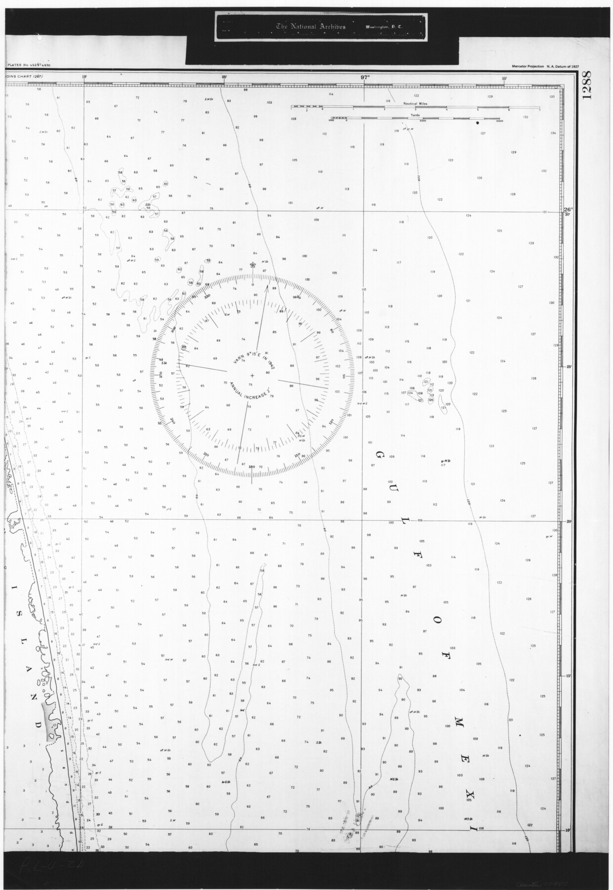
United States - Gulf Coast Texas - Southern part of Laguna Madre
RL-4-2b
-
Map/Doc
72945
-
Collection
General Map Collection
-
Object Dates
1941 (Creation Date)
-
People and Organizations
U. S. Coast and Geodetic Survey (Publisher)
U. S. Coast and Geodetic Survey (Author)
-
Subjects
Nautical Charts
-
Height x Width
26.4 x 18.2 inches
67.1 x 46.2 cm
-
Comments
B/W photostat copy from National Archives in multiple pieces.
Part of: General Map Collection

Upton County Rolled Sketch 44

Print $40.00
- Digital $50.00
Upton County Rolled Sketch 44
1955
Size 43.2 x 55.4 inches
Map/Doc 75945
Aransas County Sketch File 26

Print $28.00
- Digital $50.00
Aransas County Sketch File 26
1896
Size 5.2 x 4.7 inches
Map/Doc 13219
Cottle County Sketch File H

Print $12.00
- Digital $50.00
Cottle County Sketch File H
1976
Size 11.2 x 8.7 inches
Map/Doc 19451
Map of Bastrop County, Texas

Print $20.00
- Digital $50.00
Map of Bastrop County, Texas
1879
Size 24.6 x 24.1 inches
Map/Doc 4507
Railroad Track Map, H&TCRRCo., Falls County, Texas

Print $4.00
- Digital $50.00
Railroad Track Map, H&TCRRCo., Falls County, Texas
1918
Size 11.8 x 18.6 inches
Map/Doc 62836

Kleberg County Boundary File 2b

Print $20.00
- Digital $50.00
Kleberg County Boundary File 2b
Size 8.0 x 28.9 inches
Map/Doc 64978
Matagorda County Working Sketch 31

Print $20.00
- Digital $50.00
Matagorda County Working Sketch 31
1982
Size 17.2 x 46.9 inches
Map/Doc 70889
Jefferson County NRC Article 33.136 Sketch 3

Print $22.00
- Digital $50.00
Jefferson County NRC Article 33.136 Sketch 3
2003
Size 22.7 x 33.9 inches
Map/Doc 78610
Matagorda County Sketch File 4

Print $4.00
- Digital $50.00
Matagorda County Sketch File 4
1876
Size 7.9 x 12.8 inches
Map/Doc 30734
Dallam County Working Sketch 1

Print $20.00
- Digital $50.00
Dallam County Working Sketch 1
1905
Size 15.9 x 13.6 inches
Map/Doc 68586
You may also like
Schleicher County Sketch File 3

Print $20.00
- Digital $50.00
Schleicher County Sketch File 3
Size 28.1 x 19.9 inches
Map/Doc 12295
[Beaumont, Sour Lake and Western Ry. Right of Way and Alignment - Frisco]
![64111, [Beaumont, Sour Lake and Western Ry. Right of Way and Alignment - Frisco], General Map Collection](https://historictexasmaps.com/wmedia_w700/maps/64111.tif.jpg)
Print $20.00
- Digital $50.00
[Beaumont, Sour Lake and Western Ry. Right of Way and Alignment - Frisco]
1910
Size 19.8 x 45.9 inches
Map/Doc 64111
The United States

Print $20.00
- Digital $50.00
The United States
1902
Size 21.4 x 28.4 inches
Map/Doc 95858
[Warren Additions 3 and 4 and vicinity]
![92464, [Warren Additions 3 and 4 and vicinity], Twichell Survey Records](https://historictexasmaps.com/wmedia_w700/maps/92464-1.tif.jpg)
Print $20.00
- Digital $50.00
[Warren Additions 3 and 4 and vicinity]
Size 23.9 x 19.5 inches
Map/Doc 92464
[Sketch for Mineral Application 19560 - 19588 - San Bernard River]
![65660, [Sketch for Mineral Application 19560 - 19588 - San Bernard River], General Map Collection](https://historictexasmaps.com/wmedia_w700/maps/65660.tif.jpg)
Print $40.00
- Digital $50.00
[Sketch for Mineral Application 19560 - 19588 - San Bernard River]
Size 98.0 x 33.0 inches
Map/Doc 65660
Calhoun County Sketch File 7

Print $12.00
- Digital $50.00
Calhoun County Sketch File 7
1947
Size 14.5 x 8.9 inches
Map/Doc 35925
Montague County Sketch File 19

Print $6.00
- Digital $50.00
Montague County Sketch File 19
1924
Size 11.2 x 8.5 inches
Map/Doc 31748
Shackelford County Sketch File 3

Print $8.00
- Digital $50.00
Shackelford County Sketch File 3
1852
Size 8.2 x 7.3 inches
Map/Doc 36574
Flight Mission No. DAG-23K, Frame 152, Matagorda County

Print $20.00
- Digital $50.00
Flight Mission No. DAG-23K, Frame 152, Matagorda County
1953
Size 15.9 x 15.9 inches
Map/Doc 86500
Midland County Working Sketch Graphic Index

Print $20.00
- Digital $50.00
Midland County Working Sketch Graphic Index
1930
Size 43.3 x 35.3 inches
Map/Doc 76641
Presidio County Working Sketch 128

Print $20.00
- Digital $50.00
Presidio County Working Sketch 128
1987
Size 37.3 x 29.0 inches
Map/Doc 71806
North Part Brewster Co.

Print $40.00
- Digital $50.00
North Part Brewster Co.
1914
Size 40.1 x 48.6 inches
Map/Doc 66731