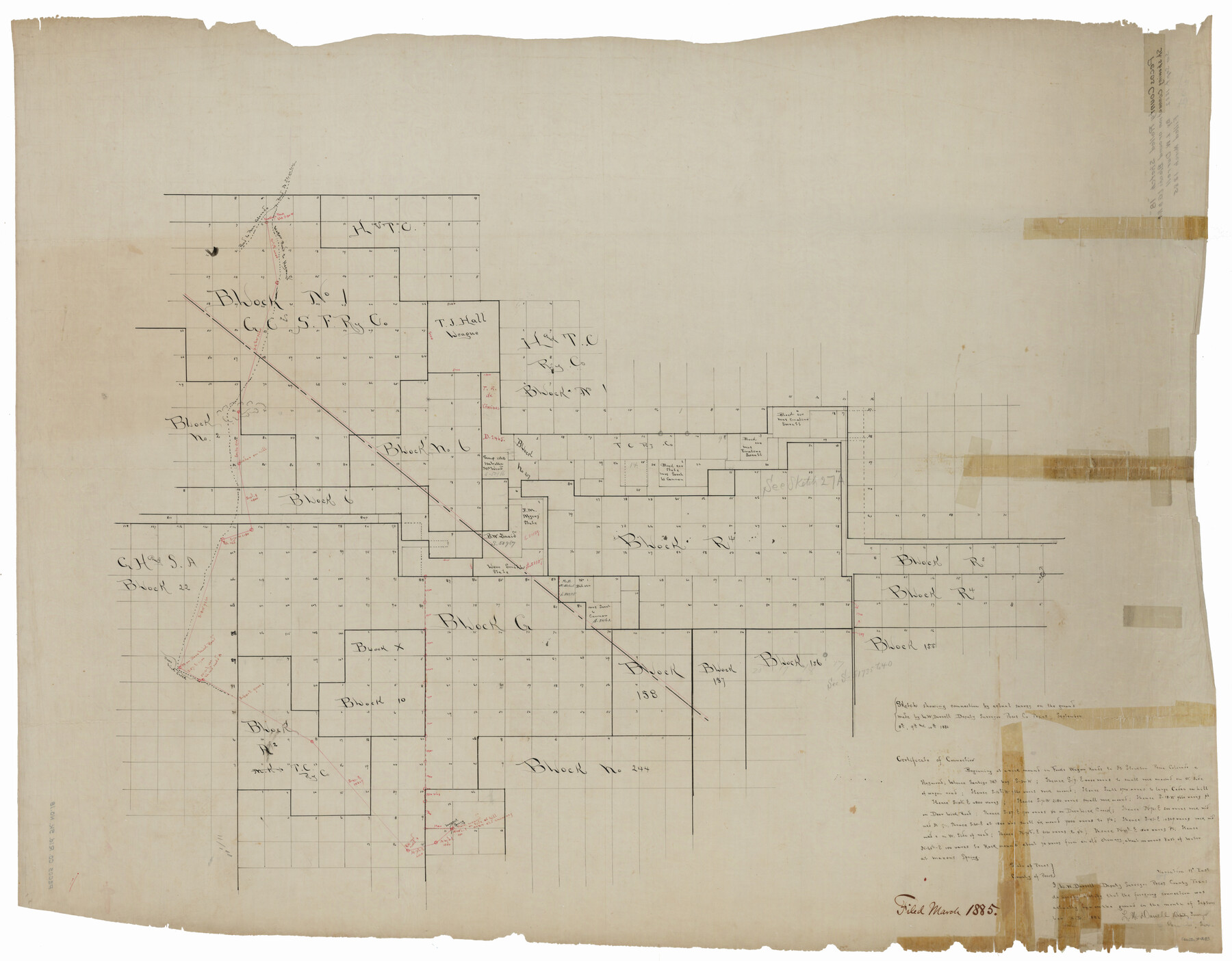
Pecos County Rolled Sketch 18
Sketch showing connection by actual survey on the ground [along border between Pecos and Brewster Counties]
-
Map/Doc
9683
-
Collection
General Map Collection
-
Object Dates
1882 (Creation Date)
1885 (File Date)
-
People and Organizations
L.W. Durrell (Surveyor/Engineer)
-
Counties
Pecos Brewster
-
Subjects
Surveying Rolled Sketch
-
Height x Width
34.4 x 44.1 inches
87.4 x 112.0 cm
-
Medium
linen, manuscript
Part of: General Map Collection
Hutchinson County Sketch File 5

Print $60.00
- Digital $50.00
Hutchinson County Sketch File 5
Size 15.1 x 62.7 inches
Map/Doc 10498
Pecos County Working Sketch 103

Print $40.00
- Digital $50.00
Pecos County Working Sketch 103
1971
Size 43.4 x 51.4 inches
Map/Doc 71576
Zapata County Sketch File 19

Print $20.00
- Digital $50.00
Zapata County Sketch File 19
1957
Size 23.5 x 13.2 inches
Map/Doc 12724
Terrell County Working Sketch 36

Print $20.00
- Digital $50.00
Terrell County Working Sketch 36
1948
Size 26.8 x 39.9 inches
Map/Doc 62129
Culberson County Working Sketch 52

Print $20.00
- Digital $50.00
Culberson County Working Sketch 52
1972
Size 37.3 x 39.5 inches
Map/Doc 68506
Val Verde County Rolled Sketch 30

Print $20.00
- Digital $50.00
Val Verde County Rolled Sketch 30
1884
Size 43.8 x 26.4 inches
Map/Doc 8111
Midland County Boundary File 5

Print $6.00
- Digital $50.00
Midland County Boundary File 5
Size 9.6 x 6.0 inches
Map/Doc 57195
Crockett County Sketch File D

Print $40.00
- Digital $50.00
Crockett County Sketch File D
1903
Size 24.6 x 48.0 inches
Map/Doc 10347
Brazoria County Sketch File 37

Print $40.00
- Digital $50.00
Brazoria County Sketch File 37
1916
Size 20.6 x 30.1 inches
Map/Doc 10959
Hardin County Working Sketch 31

Print $20.00
- Digital $50.00
Hardin County Working Sketch 31
1971
Size 43.0 x 33.2 inches
Map/Doc 63429
Denton County Texas

Print $20.00
- Digital $50.00
Denton County Texas
1896
Size 18.4 x 31.6 inches
Map/Doc 4530
Crockett County Working Sketch 67

Print $20.00
- Digital $50.00
Crockett County Working Sketch 67
1959
Size 26.5 x 31.5 inches
Map/Doc 68400
You may also like
Trinity County

Print $20.00
- Digital $50.00
Trinity County
1946
Size 40.5 x 40.7 inches
Map/Doc 77440

[Sketch showing PSL Block AX and C. C. S. D. & R. G. N. G. RR. Co. Block G]
![90912, [Sketch showing PSL Block AX and C. C. S. D. & R. G. N. G. RR. Co. Block G], Twichell Survey Records](https://historictexasmaps.com/wmedia_w700/maps/90912-1.tif.jpg)
Print $20.00
- Digital $50.00
[Sketch showing PSL Block AX and C. C. S. D. & R. G. N. G. RR. Co. Block G]
Size 26.2 x 16.4 inches
Map/Doc 90912
Culberson County Sketch File 27a

Print $28.00
- Digital $50.00
Culberson County Sketch File 27a
Size 11.2 x 8.5 inches
Map/Doc 20266
Throckmorton County Sketch File 7

Print $8.00
- Digital $50.00
Throckmorton County Sketch File 7
Size 14.3 x 8.8 inches
Map/Doc 38090
Flight Mission No. DQN-2K, Frame 115, Calhoun County

Print $20.00
- Digital $50.00
Flight Mission No. DQN-2K, Frame 115, Calhoun County
1953
Size 18.6 x 22.3 inches
Map/Doc 84291
Lavaca County Working Sketch 15

Print $20.00
- Digital $50.00
Lavaca County Working Sketch 15
1965
Size 24.6 x 43.0 inches
Map/Doc 70368
Nueces County Sketch File 69

Print $6.00
- Digital $50.00
Nueces County Sketch File 69
Size 11.1 x 8.7 inches
Map/Doc 33004
Uvalde County Sketch File 12A

Print $20.00
- Digital $50.00
Uvalde County Sketch File 12A
1887
Size 19.2 x 30.0 inches
Map/Doc 12527
Map of Texas comprising the grant of the Texian Emigration and Land-Company

Print $20.00
- Digital $50.00
Map of Texas comprising the grant of the Texian Emigration and Land-Company
1843
Size 9.4 x 10.1 inches
Map/Doc 94049
Crockett County Working Sketch 90

Print $20.00
- Digital $50.00
Crockett County Working Sketch 90
1978
Size 45.2 x 43.3 inches
Map/Doc 68423
[Maps of surveys in Reeves & Culberson Cos]
![61134, [Maps of surveys in Reeves & Culberson Cos], General Map Collection](https://historictexasmaps.com/wmedia_w700/maps/61134.tif.jpg)
Print $20.00
- Digital $50.00
[Maps of surveys in Reeves & Culberson Cos]
1937
Size 30.7 x 24.9 inches
Map/Doc 61134