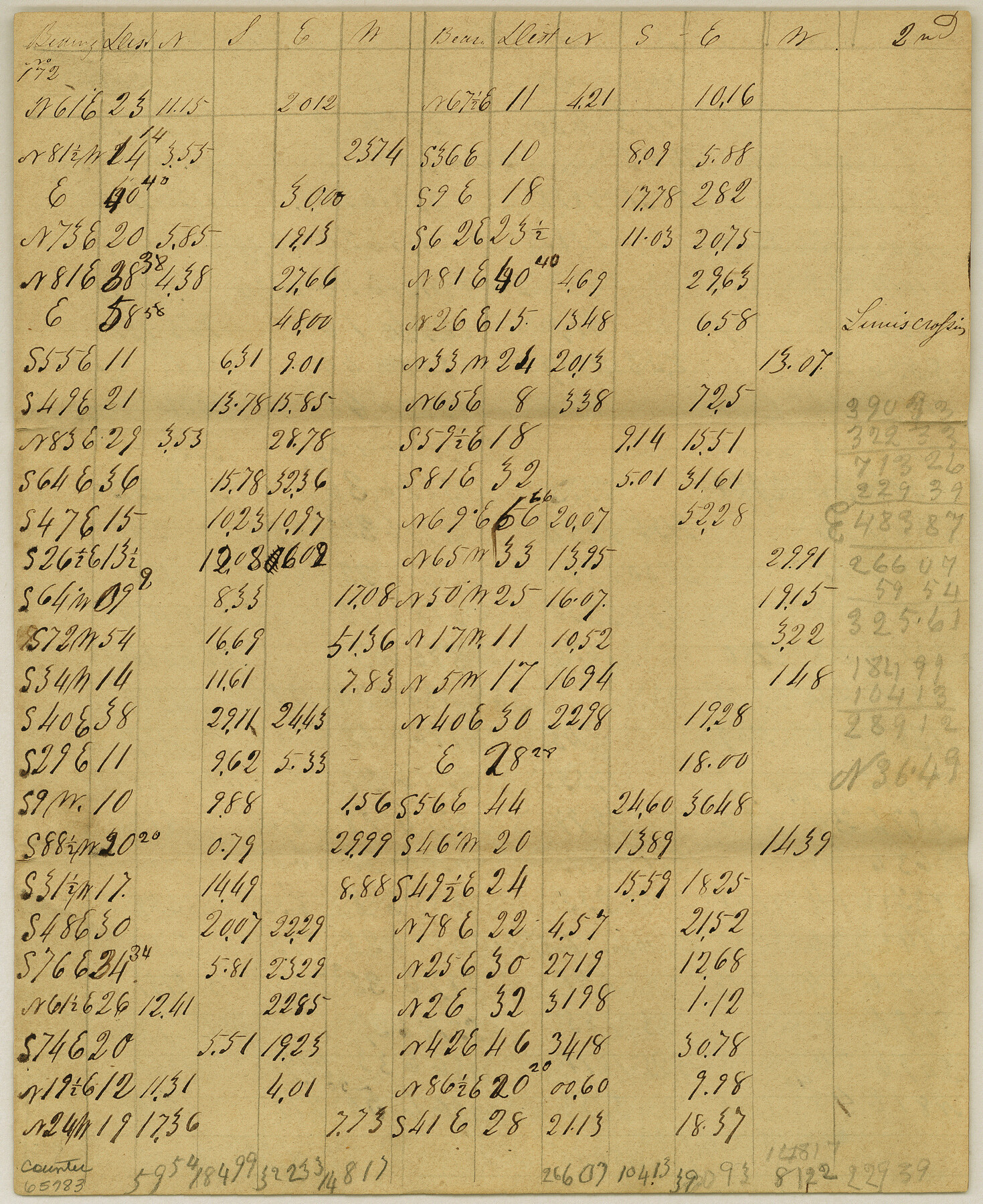
Meanders of Sulphur Fork of Red River, Red River County, Texas
K-3-7
-
Map/Doc
65783
-
Collection
General Map Collection
-
Object Dates
1841 (Creation Date)
-
Counties
Red River
-
Subjects
River Surveys
-
Height x Width
9.9 x 8.1 inches
25.1 x 20.6 cm
Part of: General Map Collection
Liberty County Working Sketch 55

Print $20.00
- Digital $50.00
Liberty County Working Sketch 55
1962
Size 30.4 x 31.4 inches
Map/Doc 70515

Hemphill County Working Sketch 17

Print $20.00
- Digital $50.00
Hemphill County Working Sketch 17
1972
Size 33.6 x 45.0 inches
Map/Doc 66112
Right of Way and Track Map International & Gt. Northern Ry. operated by the International & Gt. Northern Ry. Co., Gulf Division, Columbia Branch

Print $40.00
- Digital $50.00
Right of Way and Track Map International & Gt. Northern Ry. operated by the International & Gt. Northern Ry. Co., Gulf Division, Columbia Branch
1912
Size 25.1 x 56.5 inches
Map/Doc 64595
Brooks County Rolled Sketch 23

Print $40.00
- Digital $50.00
Brooks County Rolled Sketch 23
Size 42.4 x 74.4 inches
Map/Doc 8538
Pecos County Rolled Sketch 41

Print $20.00
- Digital $50.00
Pecos County Rolled Sketch 41
Size 22.7 x 31.3 inches
Map/Doc 7219
Jefferson County NRC Article 33.136 Sketch 4

Print $2.00
- Digital $50.00
Jefferson County NRC Article 33.136 Sketch 4
2004
Size 14.5 x 8.4 inches
Map/Doc 82993
Angelina County Sketch File 18c

Print $4.00
- Digital $50.00
Angelina County Sketch File 18c
Size 12.8 x 8.3 inches
Map/Doc 13034
![94184, Texas [Verso], General Map Collection](https://historictexasmaps.com/wmedia_w700/maps/94184.tif.jpg)
Edwards County Rolled Sketch 25

Print $20.00
- Digital $50.00
Edwards County Rolled Sketch 25
1955
Size 30.2 x 35.5 inches
Map/Doc 5811
Walker County Working Sketch 7

Print $20.00
- Digital $50.00
Walker County Working Sketch 7
1935
Size 38.3 x 43.2 inches
Map/Doc 72287
Red River County Working Sketch 12

Print $20.00
- Digital $50.00
Red River County Working Sketch 12
Size 17.3 x 20.0 inches
Map/Doc 71995
You may also like
Edwards County Sketch File 55

Print $4.00
- Digital $50.00
Edwards County Sketch File 55
1982
Size 9.1 x 14.5 inches
Map/Doc 21806
Brewster County Rolled Sketch 114

Print $20.00
- Digital $50.00
Brewster County Rolled Sketch 114
1964
Size 12.0 x 18.4 inches
Map/Doc 5278
Kimble County Sketch File 31

Print $20.00
- Digital $50.00
Kimble County Sketch File 31
1890
Size 26.0 x 24.3 inches
Map/Doc 11929
Maps & Lists Showing Prison Lands (Oil & Gas) Leased as of June 1955

Digital $50.00
Maps & Lists Showing Prison Lands (Oil & Gas) Leased as of June 1955
Size 8.7 x 11.2 inches
Map/Doc 62869
The Empresario Grants. Arthur Goodall Wavell, Proposed Expansion

Print $20.00
The Empresario Grants. Arthur Goodall Wavell, Proposed Expansion
2020
Size 16.0 x 21.7 inches
Map/Doc 96427
Flight Mission No. BRE-1P, Frame 121, Nueces County

Print $20.00
- Digital $50.00
Flight Mission No. BRE-1P, Frame 121, Nueces County
1956
Size 18.6 x 22.7 inches
Map/Doc 86687
[East Line, Hemphill County]
![90725, [East Line, Hemphill County], Twichell Survey Records](https://historictexasmaps.com/wmedia_w700/maps/90725-1.tif.jpg)
Print $2.00
- Digital $50.00
[East Line, Hemphill County]
Size 5.4 x 15.0 inches
Map/Doc 90725
Map of Matagorda County

Print $20.00
- Digital $50.00
Map of Matagorda County
1839
Size 23.5 x 32.2 inches
Map/Doc 3844
Map Showing Proposed System of State Highways as Adopted June 1917

Print $20.00
Map Showing Proposed System of State Highways as Adopted June 1917
1917
Size 20.9 x 22.4 inches
Map/Doc 76294
Webb County Rolled Sketch 25

Print $20.00
- Digital $50.00
Webb County Rolled Sketch 25
Size 28.4 x 42.4 inches
Map/Doc 8185
Flight Mission No. CRC-5R, Frame 44, Chambers County

Print $20.00
- Digital $50.00
Flight Mission No. CRC-5R, Frame 44, Chambers County
1956
Size 18.6 x 22.4 inches
Map/Doc 84963
Goliad Station Map, Galveston, Harrisburg & San Antonio Ry. operated by the T. & N. O. R.R. Co.

Print $40.00
- Digital $50.00
Goliad Station Map, Galveston, Harrisburg & San Antonio Ry. operated by the T. & N. O. R.R. Co.
1918
Size 24.7 x 55.8 inches
Map/Doc 76161