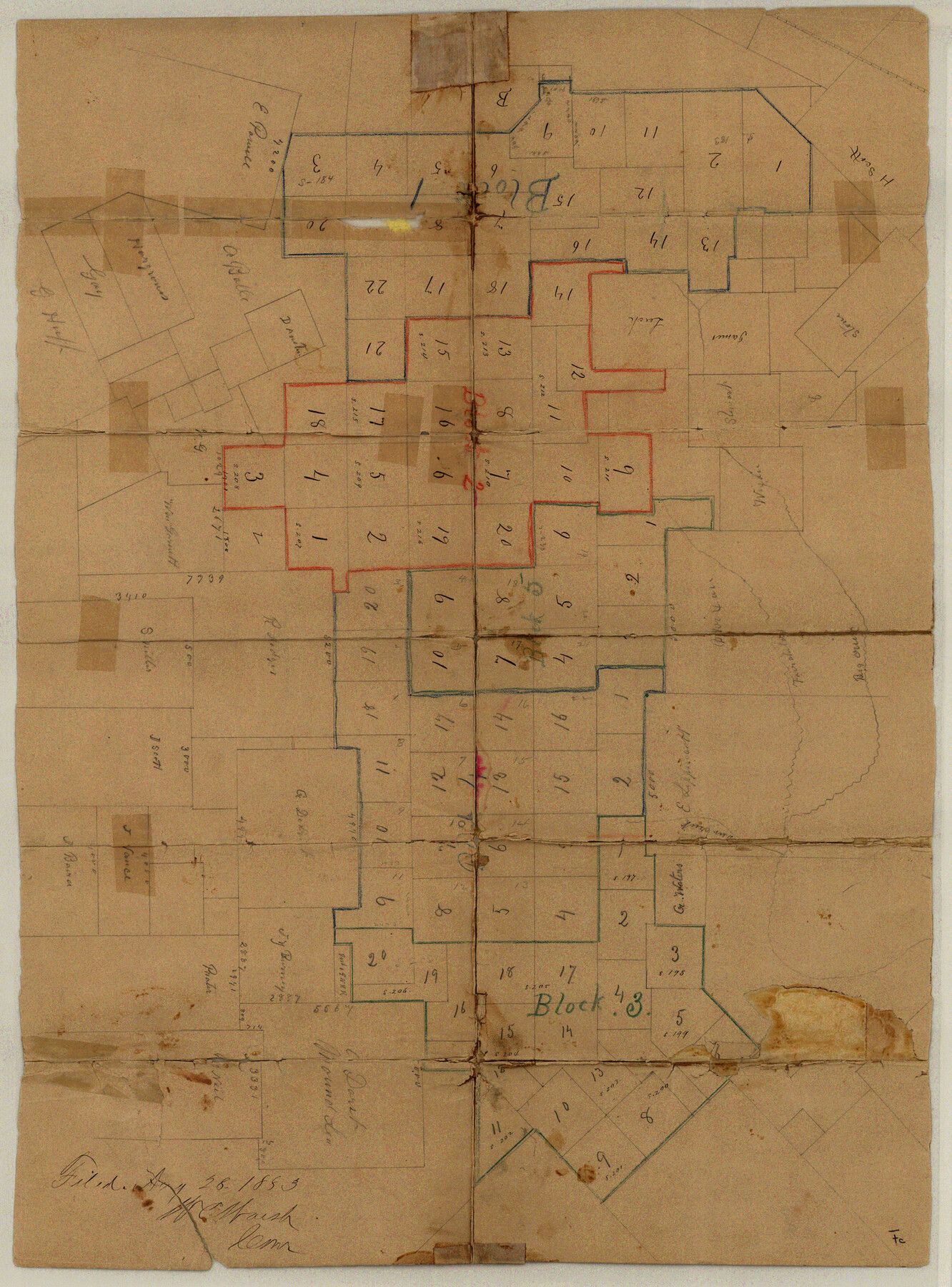
Fort Bend County Sketch File 12
[Sketch of surveys in the southwest part of the county]
-
Map/Doc
11503
-
Collection
General Map Collection
-
Object Dates
8/26/1883 (File Date)
-
Counties
Fort Bend Brazoria
-
Subjects
Surveying Sketch File
-
Height x Width
24.6 x 18.2 inches
62.5 x 46.2 cm
-
Medium
paper, manuscript
-
Features
Deer Creek
Big Creek
Part of: General Map Collection
Hunt County Sketch File 39

Print $8.00
- Digital $50.00
Hunt County Sketch File 39
1922
Size 14.3 x 8.8 inches
Map/Doc 27159
Jackson County Working Sketch 9

Print $20.00
- Digital $50.00
Jackson County Working Sketch 9
1982
Size 13.3 x 31.4 inches
Map/Doc 66457
Harris County Working Sketch 88

Print $20.00
- Digital $50.00
Harris County Working Sketch 88
1972
Size 30.3 x 38.4 inches
Map/Doc 65980
Pecos County Sketch File 62

Print $40.00
- Digital $50.00
Pecos County Sketch File 62
1919
Size 10.5 x 24.6 inches
Map/Doc 33790
Hudspeth County Rolled Sketch 69

Print $20.00
- Digital $50.00
Hudspeth County Rolled Sketch 69
1973
Size 13.3 x 20.5 inches
Map/Doc 7716
Burnet County Boundary File 12a

Print $8.00
- Digital $50.00
Burnet County Boundary File 12a
Size 12.9 x 8.7 inches
Map/Doc 50956
Rockwall County Boundary File 2

Print $12.00
- Digital $50.00
Rockwall County Boundary File 2
Size 14.4 x 8.9 inches
Map/Doc 58385
Austin including Bergstrom AFB, Hays, Mansfield Dam, McKinney Falls State Park, Oak Hill, Rollingwood, San Leanna, Sunset Valley and West Lake Hills - also portions of Pflugerville

Austin including Bergstrom AFB, Hays, Mansfield Dam, McKinney Falls State Park, Oak Hill, Rollingwood, San Leanna, Sunset Valley and West Lake Hills - also portions of Pflugerville
Size 38.5 x 25.6 inches
Map/Doc 94376
El Paso County Rolled Sketch 33

Print $42.00
- Digital $50.00
El Paso County Rolled Sketch 33
Size 35.1 x 25.6 inches
Map/Doc 8867
Uvalde County Boundary File 2

Print $5.00
- Digital $50.00
Uvalde County Boundary File 2
Size 13.1 x 9.5 inches
Map/Doc 59556
Hemphill County Sketch File 9

Print $26.00
- Digital $50.00
Hemphill County Sketch File 9
1955
Size 11.0 x 8.8 inches
Map/Doc 26312
Uvalde County Sketch File 30

Print $12.00
- Digital $50.00
Uvalde County Sketch File 30
1990
Size 4.4 x 9.9 inches
Map/Doc 39032
You may also like
Menard County

Print $20.00
- Digital $50.00
Menard County
1894
Size 32.5 x 42.1 inches
Map/Doc 66926
Flight Mission No. BRA-9M, Frame 60, Jefferson County

Print $20.00
- Digital $50.00
Flight Mission No. BRA-9M, Frame 60, Jefferson County
1953
Size 18.6 x 22.4 inches
Map/Doc 85643
C. B. Livestock Co.'s West-Ranch, Bailey County, Texas

Print $2.00
- Digital $50.00
C. B. Livestock Co.'s West-Ranch, Bailey County, Texas
Size 11.2 x 8.9 inches
Map/Doc 90381
Flight Mission No. DQO-6K, Frame 22, Galveston County

Print $20.00
- Digital $50.00
Flight Mission No. DQO-6K, Frame 22, Galveston County
1952
Size 18.8 x 22.4 inches
Map/Doc 85095
Val Verde County Sketch File Z11

Print $40.00
- Digital $50.00
Val Verde County Sketch File Z11
1895
Size 17.6 x 12.7 inches
Map/Doc 39138
Hale County Sketch File 3a

Print $20.00
- Digital $50.00
Hale County Sketch File 3a
Size 21.1 x 14.6 inches
Map/Doc 11593
Sutton County Rolled Sketch 42

Print $20.00
- Digital $50.00
Sutton County Rolled Sketch 42
Size 16.2 x 20.1 inches
Map/Doc 7884
[Sketch of surveys in the Bexar District along the Pedernales River]
![103, [Sketch of surveys in the Bexar District along the Pedernales River], General Map Collection](https://historictexasmaps.com/wmedia_w700/maps/103-1.tif.jpg)
Print $2.00
- Digital $50.00
[Sketch of surveys in the Bexar District along the Pedernales River]
1847
Size 13.6 x 8.3 inches
Map/Doc 103
Uvalde County Working Sketch 56

Print $20.00
- Digital $50.00
Uvalde County Working Sketch 56
1985
Size 44.8 x 40.6 inches
Map/Doc 72126
Harris County Sketch File 59

Print $32.00
- Digital $50.00
Harris County Sketch File 59
1921
Size 14.3 x 9.0 inches
Map/Doc 25480
Harris County Working Sketch 10

Print $20.00
- Digital $50.00
Harris County Working Sketch 10
1912
Size 25.7 x 18.1 inches
Map/Doc 65902
Yoakum County

Print $20.00
- Digital $50.00
Yoakum County
1938
Size 24.9 x 24.6 inches
Map/Doc 92446