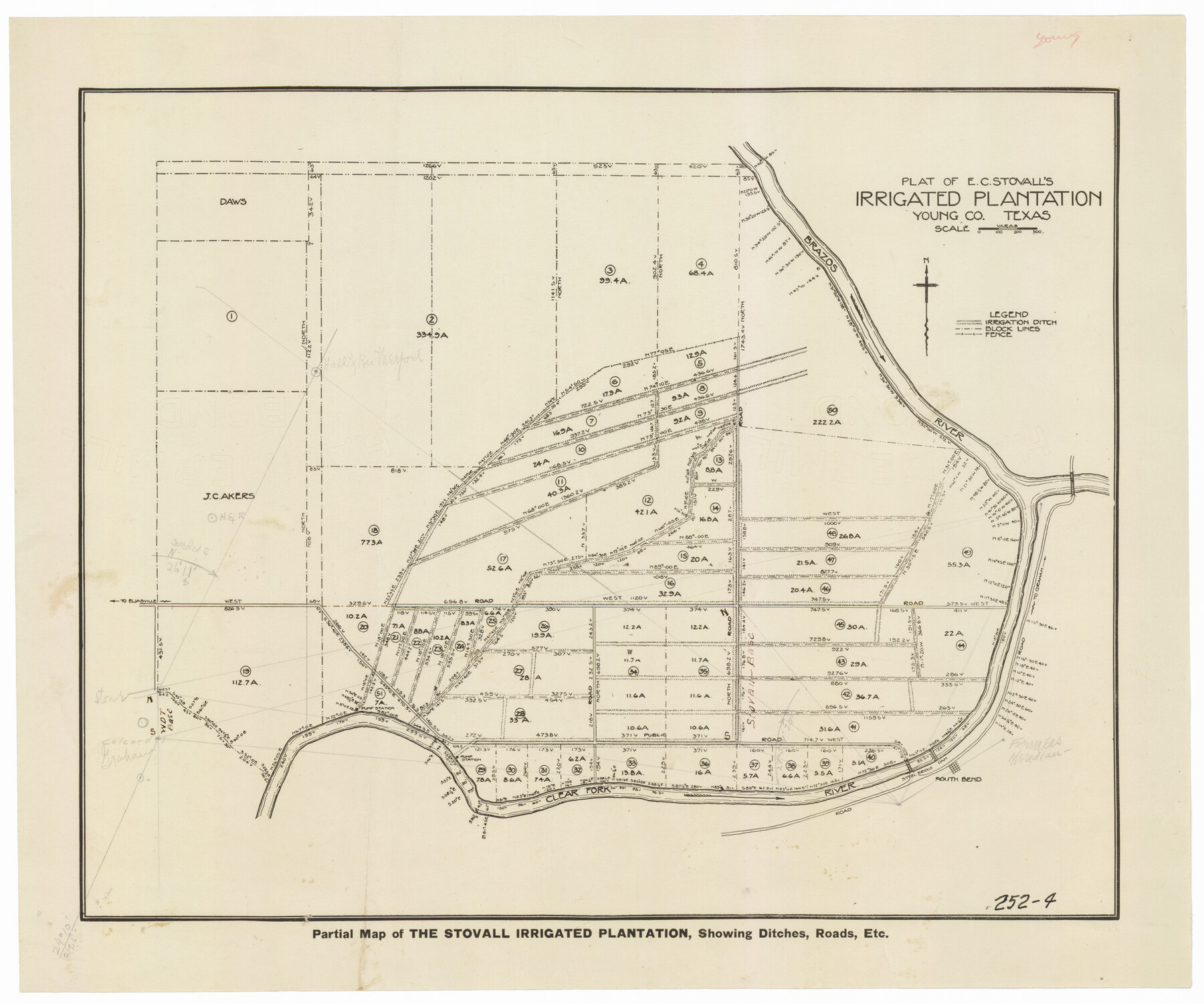
Plat of E. C. Stovall's Irrigated Plantation, Young Co., Texas
252-4
-
Map/Doc
92019
-
Collection
Twichell Survey Records
-
Counties
Young
-
Height x Width
17.6 x 14.7 inches
44.7 x 37.3 cm
Part of: Twichell Survey Records
[SE/4 of NW/4 of King Co.]
![89925, [SE/4 of NW/4 of King Co.], Twichell Survey Records](https://historictexasmaps.com/wmedia_w700/maps/89925-1.tif.jpg)
Print $40.00
- Digital $50.00
[SE/4 of NW/4 of King Co.]
Size 43.7 x 55.5 inches
Map/Doc 89925
Map of Public Roads in Terry County, Texas

Print $20.00
- Digital $50.00
Map of Public Roads in Terry County, Texas
Size 34.0 x 37.4 inches
Map/Doc 91936
[Leagues 53 through 57]
![92483, [Leagues 53 through 57], Twichell Survey Records](https://historictexasmaps.com/wmedia_w700/maps/92483-1.tif.jpg)
Print $20.00
- Digital $50.00
[Leagues 53 through 57]
1913
Size 17.8 x 19.0 inches
Map/Doc 92483
[Western part of Crockett County]
![90323, [Western part of Crockett County], Twichell Survey Records](https://historictexasmaps.com/wmedia_w700/maps/90323-1.tif.jpg)
Print $20.00
- Digital $50.00
[Western part of Crockett County]
Size 17.3 x 14.3 inches
Map/Doc 90323
[Leagues 7, 8, 9, and 10]
![92218, [Leagues 7, 8, 9, and 10], Twichell Survey Records](https://historictexasmaps.com/wmedia_w700/maps/92218-1.tif.jpg)
Print $20.00
- Digital $50.00
[Leagues 7, 8, 9, and 10]
1943
Size 20.0 x 13.4 inches
Map/Doc 92218
General Highway Map of Garza County, Texas

Print $20.00
- Digital $50.00
General Highway Map of Garza County, Texas
1950
Size 25.9 x 18.8 inches
Map/Doc 92646
[Blocks XO3 and I]
![91167, [Blocks XO3 and I], Twichell Survey Records](https://historictexasmaps.com/wmedia_w700/maps/91167-1.tif.jpg)
Print $2.00
- Digital $50.00
[Blocks XO3 and I]
Size 6.5 x 11.8 inches
Map/Doc 91167

Map Showing 949 3/10 Acres in the L. Brock, Sam Shupe, R. de la Pena, S. A. & G. M. RR. Surveys

Print $20.00
- Digital $50.00
Map Showing 949 3/10 Acres in the L. Brock, Sam Shupe, R. de la Pena, S. A. & G. M. RR. Surveys
1921
Size 19.5 x 14.9 inches
Map/Doc 92642
Section O Tech Memorial Park, Inc.

Print $20.00
- Digital $50.00
Section O Tech Memorial Park, Inc.
1950
Size 17.2 x 19.2 inches
Map/Doc 92299
[Block T, Sabine County School Land, and vicinity]
![92250, [Block T, Sabine County School Land, and vicinity], Twichell Survey Records](https://historictexasmaps.com/wmedia_w700/maps/92250-1.tif.jpg)
Print $20.00
- Digital $50.00
[Block T, Sabine County School Land, and vicinity]
Size 35.7 x 32.0 inches
Map/Doc 92250
Garza County Sketch

Print $20.00
- Digital $50.00
Garza County Sketch
1924
Size 19.6 x 18.4 inches
Map/Doc 92701
You may also like
[Block K5, Section 13]
![91452, [Block K5, Section 13], Twichell Survey Records](https://historictexasmaps.com/wmedia_w700/maps/91452-1.tif.jpg)
Print $20.00
- Digital $50.00
[Block K5, Section 13]
Size 22.2 x 18.5 inches
Map/Doc 91452
Map of Wharton County

Print $20.00
- Digital $50.00
Map of Wharton County
1884
Size 24.8 x 28.0 inches
Map/Doc 4137
Nueces County Sketch File 86

Print $2.00
- Digital $50.00
Nueces County Sketch File 86
Map/Doc 81935
Kimble County Sketch File 9a

Print $4.00
- Digital $50.00
Kimble County Sketch File 9a
Size 12.4 x 9.2 inches
Map/Doc 28929
[Parts of Public School Land Blocks 39, 31, C-40, C-42, E. L. & R. R. Blocks H, I]
![91271, [Parts of Public School Land Blocks 39, 31, C-40, C-42, E. L. & R. R. Blocks H, I], Twichell Survey Records](https://historictexasmaps.com/wmedia_w700/maps/91271-1.tif.jpg)
Print $20.00
- Digital $50.00
[Parts of Public School Land Blocks 39, 31, C-40, C-42, E. L. & R. R. Blocks H, I]
Size 14.2 x 19.5 inches
Map/Doc 91271
Brown County Sketch File 12a

Print $8.00
- Digital $50.00
Brown County Sketch File 12a
1870
Size 12.4 x 8.1 inches
Map/Doc 16604
Falls County Sketch File 3

Print $3.00
- Digital $50.00
Falls County Sketch File 3
1847
Size 10.8 x 16.5 inches
Map/Doc 11465
[I. & G. N. Block 1, sections 57-70]
![91668, [I. & G. N. Block 1, sections 57-70], Twichell Survey Records](https://historictexasmaps.com/wmedia_w700/maps/91668-1.tif.jpg)
Print $20.00
- Digital $50.00
[I. & G. N. Block 1, sections 57-70]
Size 28.8 x 22.1 inches
Map/Doc 91668
Flight Mission No. DCL-7C, Frame 57, Kenedy County

Print $20.00
- Digital $50.00
Flight Mission No. DCL-7C, Frame 57, Kenedy County
1943
Size 15.4 x 15.2 inches
Map/Doc 86045
Kimble County Working Sketch 18

Print $20.00
- Digital $50.00
Kimble County Working Sketch 18
1924
Size 19.1 x 14.4 inches
Map/Doc 70086
Eastland County Working Sketch 4

Print $20.00
- Digital $50.00
Eastland County Working Sketch 4
1918
Size 39.1 x 29.1 inches
Map/Doc 68785
Flight Mission No. CGI-1N, Frame 166, Cameron County

Print $20.00
- Digital $50.00
Flight Mission No. CGI-1N, Frame 166, Cameron County
1955
Size 18.5 x 22.2 inches
Map/Doc 84501