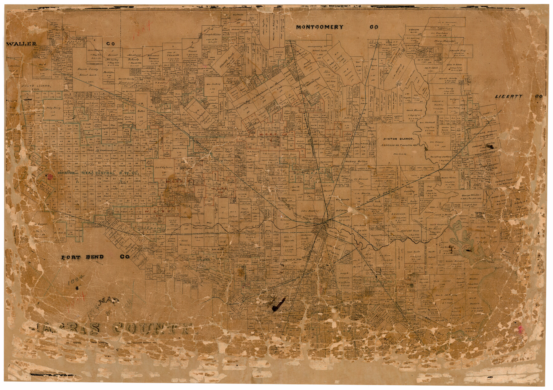
Harris County
-
Map/Doc
3636
-
Collection
General Map Collection
-
Object Dates
1884 (Creation Date)
-
Counties
Harris
-
Subjects
County
-
Height x Width
24.1 x 34.2 inches
61.2 x 86.9 cm
-
Comments
Probably drawn by Schmidt.
Conservation funded in 2004 with donation from David T. Field. -
Features
Morgan's Point
GH&SA
TTR
Vince's Bayou
Sims Bayou
Greens Bayou
Carpenters Bayou
Burnets Bay
McCormincks Bay
Spilmans Island
GH&H
Goose Creek
Clear Lake
WT
Middle Bayou
Hog Island
Eureka
Clear Creek
Scott's Bay
Harrisburg
Bear Creek
Willow Creek
San Jacinto River
HE&WT
I&GN
H&TC
Cypress
Hockley
Halls Bayou
T&NO
Spring Creek
Hunting Bayou
White Oak Bayou
TCRR
Horsepen Creek
Spring Bayou
TWNG
Buffalo Bayou
Brays Bayou
Houston
Part of: General Map Collection
Glasscock County Working Sketch 17

Print $20.00
- Digital $50.00
Glasscock County Working Sketch 17
1990
Size 27.7 x 30.6 inches
Map/Doc 63190
Concho County Working Sketch 23

Print $20.00
- Digital $50.00
Concho County Working Sketch 23
1975
Size 21.9 x 27.1 inches
Map/Doc 68205
Angelina River, Mud Creek, Sheet 2

Print $4.00
- Digital $50.00
Angelina River, Mud Creek, Sheet 2
1937
Size 26.4 x 18.9 inches
Map/Doc 65076
Sulphur River, Ringo Crossing Sheet

Print $20.00
- Digital $50.00
Sulphur River, Ringo Crossing Sheet
1933
Size 18.5 x 20.4 inches
Map/Doc 78334
Mills County Sketch File 6

Print $4.00
- Digital $50.00
Mills County Sketch File 6
Size 9.0 x 9.8 inches
Map/Doc 31655
Bosque County Working Sketch 20

Print $20.00
- Digital $50.00
Bosque County Working Sketch 20
1976
Size 37.4 x 32.8 inches
Map/Doc 67453
Wichita County Sketch File 33

Print $6.00
- Digital $50.00
Wichita County Sketch File 33
1949
Size 11.0 x 17.0 inches
Map/Doc 40152
Jackson County Boundary File 1

Print $24.00
- Digital $50.00
Jackson County Boundary File 1
Size 9.0 x 3.9 inches
Map/Doc 55420
Hood County Working Sketch 9

Print $20.00
- Digital $50.00
Hood County Working Sketch 9
1972
Size 28.0 x 31.7 inches
Map/Doc 66203
Trinity River, Hutchins Bridge Sheet

Print $20.00
- Digital $50.00
Trinity River, Hutchins Bridge Sheet
1922
Size 38.6 x 33.2 inches
Map/Doc 65190
Presidio County Working Sketch 69

Print $20.00
- Digital $50.00
Presidio County Working Sketch 69
1960
Size 33.3 x 41.3 inches
Map/Doc 71746

You may also like
Presidio County Rolled Sketch 40

Print $20.00
- Digital $50.00
Presidio County Rolled Sketch 40
1907
Size 16.5 x 21.5 inches
Map/Doc 7337
[River Sections 58-62 and vicinity]
![91587, [River Sections 58-62 and vicinity], Twichell Survey Records](https://historictexasmaps.com/wmedia_w700/maps/91587-1.tif.jpg)
Print $20.00
- Digital $50.00
[River Sections 58-62 and vicinity]
Size 17.6 x 14.6 inches
Map/Doc 91587
Comanche County Working Sketch 10

Print $20.00
- Digital $50.00
Comanche County Working Sketch 10
1954
Size 21.4 x 18.0 inches
Map/Doc 68144
General Highway Map. Detail of Cities and Towns in Galveston County, Texas. City Map of Galveston and vicinity, Galveston County, Texas

Print $20.00
General Highway Map. Detail of Cities and Towns in Galveston County, Texas. City Map of Galveston and vicinity, Galveston County, Texas
1961
Size 18.1 x 24.6 inches
Map/Doc 79477
Montague County Working Sketch 41

Print $40.00
- Digital $50.00
Montague County Working Sketch 41
1923
Size 43.0 x 66.1 inches
Map/Doc 65349
Randall County Rolled Sketch 2

Print $20.00
- Digital $50.00
Randall County Rolled Sketch 2
1941
Size 31.9 x 23.9 inches
Map/Doc 7422
Brewster County Rolled Sketch 49

Print $20.00
- Digital $50.00
Brewster County Rolled Sketch 49
1930
Size 35.1 x 47.4 inches
Map/Doc 8478
Sketch showing resurvey of Blk 34 Tsp. 4 North

Print $20.00
- Digital $50.00
Sketch showing resurvey of Blk 34 Tsp. 4 North
1917
Size 20.8 x 24.5 inches
Map/Doc 90571
Collin County, Texas

Print $20.00
- Digital $50.00
Collin County, Texas
1879
Size 19.6 x 17.0 inches
Map/Doc 559
Topographical Map of the Rio Grande, Sheet No. 7

Print $20.00
- Digital $50.00
Topographical Map of the Rio Grande, Sheet No. 7
1912
Map/Doc 89531
Wise County Sketch File 26

Print $22.00
- Digital $50.00
Wise County Sketch File 26
1855
Size 8.1 x 14.3 inches
Map/Doc 40574
[Capitol Land Leagues and Blocks M6, 10T, T1, O5 and part of Block B]
![93194, [Capitol Land Leagues and Blocks M6, 10T, T1, O5 and part of Block B], Twichell Survey Records](https://historictexasmaps.com/wmedia_w700/maps/93194-1.tif.jpg)
Print $40.00
- Digital $50.00
[Capitol Land Leagues and Blocks M6, 10T, T1, O5 and part of Block B]
Size 43.7 x 105.6 inches
Map/Doc 93194