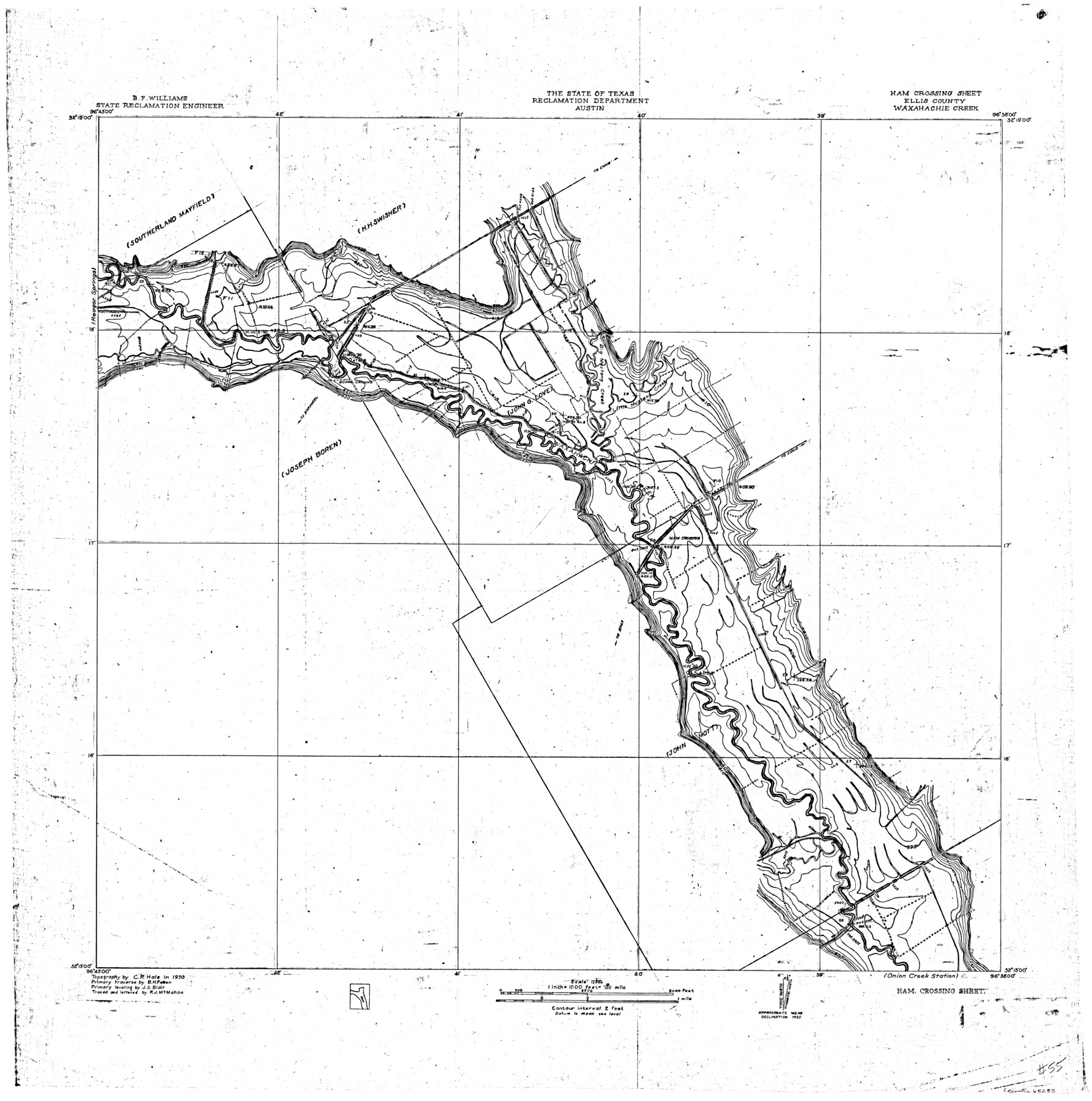
Trinity River, Ham Crossing Sheet/Waxahachie Creek
-
Map/Doc
65235
-
Collection
General Map Collection
-
Object Dates
1930 (Creation Date)
-
People and Organizations
Texas State Reclamation Department (Publisher)
Curtis R. Hale (Surveyor/Engineer)
R.J. McMahon (Draftsman)
R.J. McMahon (Compiler)
J.C. Blair (Surveyor/Engineer)
B.H. Faber (Surveyor/Engineer)
-
Counties
Ellis
-
Subjects
River Surveys Topographic
-
Height x Width
31.4 x 31.1 inches
79.8 x 79.0 cm
-
Comments
Ham Crossing Sheet located north of the Onion Creek Station Sheet and east of the Reagor Springs Sheet.
Part of: General Map Collection
Knox County Boundary File 1a

Print $16.00
- Digital $50.00
Knox County Boundary File 1a
Size 9.7 x 13.8 inches
Map/Doc 65010
Andrews County Rolled Sketch 43

Print $20.00
- Digital $50.00
Andrews County Rolled Sketch 43
Size 26.1 x 41.0 inches
Map/Doc 77183
Coleman County Sketch File A2

Print $5.00
- Digital $50.00
Coleman County Sketch File A2
1879
Size 9.2 x 10.8 inches
Map/Doc 18667
Navigation Maps of Gulf Intracoastal Waterway, Port Arthur to Brownsville, Texas

Print $4.00
- Digital $50.00
Navigation Maps of Gulf Intracoastal Waterway, Port Arthur to Brownsville, Texas
1951
Size 16.5 x 21.1 inches
Map/Doc 65435
San Patricio County Sketch File 18

Print $4.00
San Patricio County Sketch File 18
Size 6.2 x 8.3 inches
Map/Doc 36066
Motley County Sketch File 37 (S)

Print $22.00
- Digital $50.00
Motley County Sketch File 37 (S)
Size 11.3 x 8.7 inches
Map/Doc 32222
Controlled Mosaic by Jack Amman Photogrammetric Engineers, Inc - Sheet 9

Print $20.00
- Digital $50.00
Controlled Mosaic by Jack Amman Photogrammetric Engineers, Inc - Sheet 9
1954
Size 20.0 x 24.0 inches
Map/Doc 83453
[Map of the Houston and Great Northern R. R. from Trinity River to Palestine]
![64550, [Map of the Houston and Great Northern R. R. from Trinity River to Palestine], General Map Collection](https://historictexasmaps.com/wmedia_w700/maps/64550.tif.jpg)
Print $40.00
- Digital $50.00
[Map of the Houston and Great Northern R. R. from Trinity River to Palestine]
1872
Size 30.0 x 88.0 inches
Map/Doc 64550
Lamar County Sketch File 14

Print $4.00
- Digital $50.00
Lamar County Sketch File 14
1873
Size 12.7 x 8.1 inches
Map/Doc 29308
North and South Sulphur Rivers, Sulphur Bluff Sheet

Print $20.00
- Digital $50.00
North and South Sulphur Rivers, Sulphur Bluff Sheet
1933
Size 37.6 x 37.2 inches
Map/Doc 65163
Matagorda County Rolled Sketch 30

Print $20.00
- Digital $50.00
Matagorda County Rolled Sketch 30
1937
Size 24.9 x 35.0 inches
Map/Doc 6693
Parker County Sketch File 14

Print $20.00
- Digital $50.00
Parker County Sketch File 14
1853
Size 25.6 x 10.3 inches
Map/Doc 12143
You may also like
Map of T. C. Spearman's Lands in Gaines, Terry and Yoakum Counties, Texas

Print $3.00
- Digital $50.00
Map of T. C. Spearman's Lands in Gaines, Terry and Yoakum Counties, Texas
1917
Size 12.4 x 10.2 inches
Map/Doc 92002
The Land Offices. No. 9, Gonzales, December 22, 1836

Print $20.00
The Land Offices. No. 9, Gonzales, December 22, 1836
2020
Size 22.3 x 21.7 inches
Map/Doc 96422
Lampasas County Boundary File 15a

Print $33.00
- Digital $50.00
Lampasas County Boundary File 15a
Size 13.3 x 8.2 inches
Map/Doc 56210
Atascosa County Rolled Sketch 22

Print $40.00
- Digital $50.00
Atascosa County Rolled Sketch 22
1917
Size 26.5 x 57.2 inches
Map/Doc 8922
Hudspeth County Sketch File 47

Print $30.00
- Digital $50.00
Hudspeth County Sketch File 47
1978
Size 14.5 x 8.9 inches
Map/Doc 27050
Galveston County Sketch File 68

Print $62.00
- Digital $50.00
Galveston County Sketch File 68
Size 4.4 x 9.7 inches
Map/Doc 23784
Map showing the line of march of the Centre Division, Army of Mexico, under the command of Brigr. Genl. John E. Wool, from San Antonio de Bexar, Texas to Saltillo, Mexico

Print $20.00
- Digital $50.00
Map showing the line of march of the Centre Division, Army of Mexico, under the command of Brigr. Genl. John E. Wool, from San Antonio de Bexar, Texas to Saltillo, Mexico
1846
Size 24.5 x 19.5 inches
Map/Doc 94074
Louisiana and Texas for the Winter Tourist

Louisiana and Texas for the Winter Tourist
1911
Map/Doc 96716
Jones County Sketch File 5

Print $4.00
- Digital $50.00
Jones County Sketch File 5
1859
Size 10.0 x 8.1 inches
Map/Doc 28492
Brewster County Working Sketch Graphic Index, North Part, Sheet 2 (Sketches 87 to Most Recent)

Print $20.00
- Digital $50.00
Brewster County Working Sketch Graphic Index, North Part, Sheet 2 (Sketches 87 to Most Recent)
1956
Size 41.8 x 39.5 inches
Map/Doc 76474
Flight Mission No. CLL-1N, Frame 82, Willacy County

Print $20.00
- Digital $50.00
Flight Mission No. CLL-1N, Frame 82, Willacy County
1954
Size 18.3 x 22.1 inches
Map/Doc 87028
[Sketch showing positions of surveys bordering on South boundary line of Archer County and North boundary line of Young County

Print $20.00
- Digital $50.00
[Sketch showing positions of surveys bordering on South boundary line of Archer County and North boundary line of Young County
1894
Size 14.0 x 36.8 inches
Map/Doc 90174