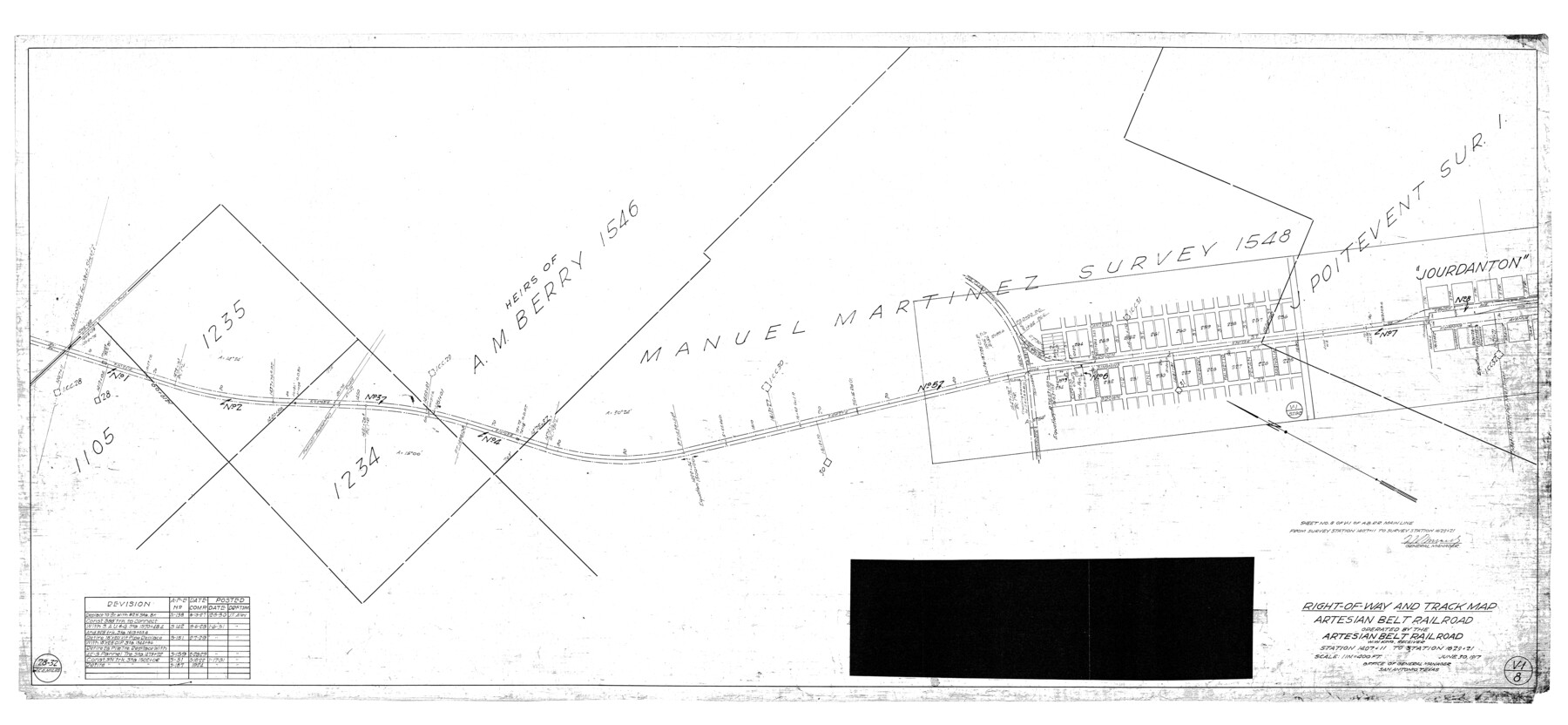
Atascosa County Rolled Sketch 22
Right-of-Way and track map, Artesian Belt Railroad operated by the Artesian Belt Railroad, W.W. King, Receiver - Station 1407+11 to Station 1629+21
-
Map/Doc
8922
-
Collection
General Map Collection
-
Object Dates
6/30/1917 (Creation Date)
2/10/1976 (File Date)
-
Counties
Atascosa
-
Subjects
Railroads Surveying Rolled Sketch
-
Height x Width
26.5 x 57.2 inches
67.3 x 145.3 cm
-
Medium
blueprint/diazo
-
Scale
1" = 400 feet
Part of: General Map Collection
Flight Mission No. DQO-8K, Frame 72, Galveston County

Print $20.00
- Digital $50.00
Flight Mission No. DQO-8K, Frame 72, Galveston County
1952
Size 18.7 x 22.4 inches
Map/Doc 85176
Dimmit County Rolled Sketch 15

Print $20.00
- Digital $50.00
Dimmit County Rolled Sketch 15
1925
Size 32.8 x 23.4 inches
Map/Doc 5723
Kinney County Sketch File 29

Print $20.00
- Digital $50.00
Kinney County Sketch File 29
1933
Size 15.5 x 21.1 inches
Map/Doc 11947
Shelby County Sketch File 28

Print $4.00
- Digital $50.00
Shelby County Sketch File 28
Size 6.2 x 7.9 inches
Map/Doc 36664
Brewster County Working Sketch 23

Print $20.00
- Digital $50.00
Brewster County Working Sketch 23
1939
Size 26.7 x 43.6 inches
Map/Doc 67557
Shelby County Working Sketch 31a

Print $40.00
- Digital $50.00
Shelby County Working Sketch 31a
2003
Size 32.6 x 70.2 inches
Map/Doc 78643
Hunt County Sketch File 1

Print $4.00
- Digital $50.00
Hunt County Sketch File 1
1853
Size 7.6 x 5.1 inches
Map/Doc 27081
Plat of a survey of the North part of section 16, Block 362, Martha McBride, Presidio County, Texas

Print $4.00
- Digital $50.00
Plat of a survey of the North part of section 16, Block 362, Martha McBride, Presidio County, Texas
1989
Size 24.1 x 29.3 inches
Map/Doc 60520
Floyd County Sketch File 25

Print $14.00
- Digital $50.00
Floyd County Sketch File 25
1912
Size 11.5 x 9.0 inches
Map/Doc 22782
Hill County Working Sketch 2

Print $20.00
- Digital $50.00
Hill County Working Sketch 2
1947
Size 24.2 x 26.7 inches
Map/Doc 66188
Galveston County Rolled Sketch 20

Print $20.00
- Digital $50.00
Galveston County Rolled Sketch 20
1970
Size 35.0 x 35.0 inches
Map/Doc 9080
University Lands Blocks 1 to 11 Andrews-Martin-Gaines-Dawson-Winkler Counties

Print $6.00
- Digital $50.00
University Lands Blocks 1 to 11 Andrews-Martin-Gaines-Dawson-Winkler Counties
Size 30.9 x 35.3 inches
Map/Doc 62930
You may also like
Flight Mission No. DCL-6C, Frame 29, Kenedy County

Print $20.00
- Digital $50.00
Flight Mission No. DCL-6C, Frame 29, Kenedy County
1943
Size 18.6 x 22.4 inches
Map/Doc 85886
Webb County Sketch File 19

Print $15.00
- Digital $50.00
Webb County Sketch File 19
1902
Size 9.2 x 17.0 inches
Map/Doc 39822
Fort Bend County

Print $20.00
- Digital $50.00
Fort Bend County
1865
Size 18.2 x 21.8 inches
Map/Doc 3550
Montague County Working Sketch 13

Print $20.00
- Digital $50.00
Montague County Working Sketch 13
1939
Size 26.0 x 20.6 inches
Map/Doc 71079
Flight Mission No. DQN-2K, Frame 97, Calhoun County

Print $20.00
- Digital $50.00
Flight Mission No. DQN-2K, Frame 97, Calhoun County
1953
Size 18.7 x 22.4 inches
Map/Doc 84287
Trinity County Working Sketch 2

Print $20.00
- Digital $50.00
Trinity County Working Sketch 2
1905
Size 16.7 x 13.6 inches
Map/Doc 69450
Guadalupe County Sketch File 8

Print $7.00
- Digital $50.00
Guadalupe County Sketch File 8
1871
Size 10.4 x 8.3 inches
Map/Doc 24674
Hale County Rolled Sketch 10

Print $40.00
- Digital $50.00
Hale County Rolled Sketch 10
Size 52.4 x 28.3 inches
Map/Doc 76447

Throckmorton County Boundary File 5

Print $8.00
- Digital $50.00
Throckmorton County Boundary File 5
Size 14.3 x 8.9 inches
Map/Doc 59286
Old Miscellaneous File 38

Print $40.00
- Digital $50.00
Old Miscellaneous File 38
1841
Size 57.8 x 33.9 inches
Map/Doc 75282
