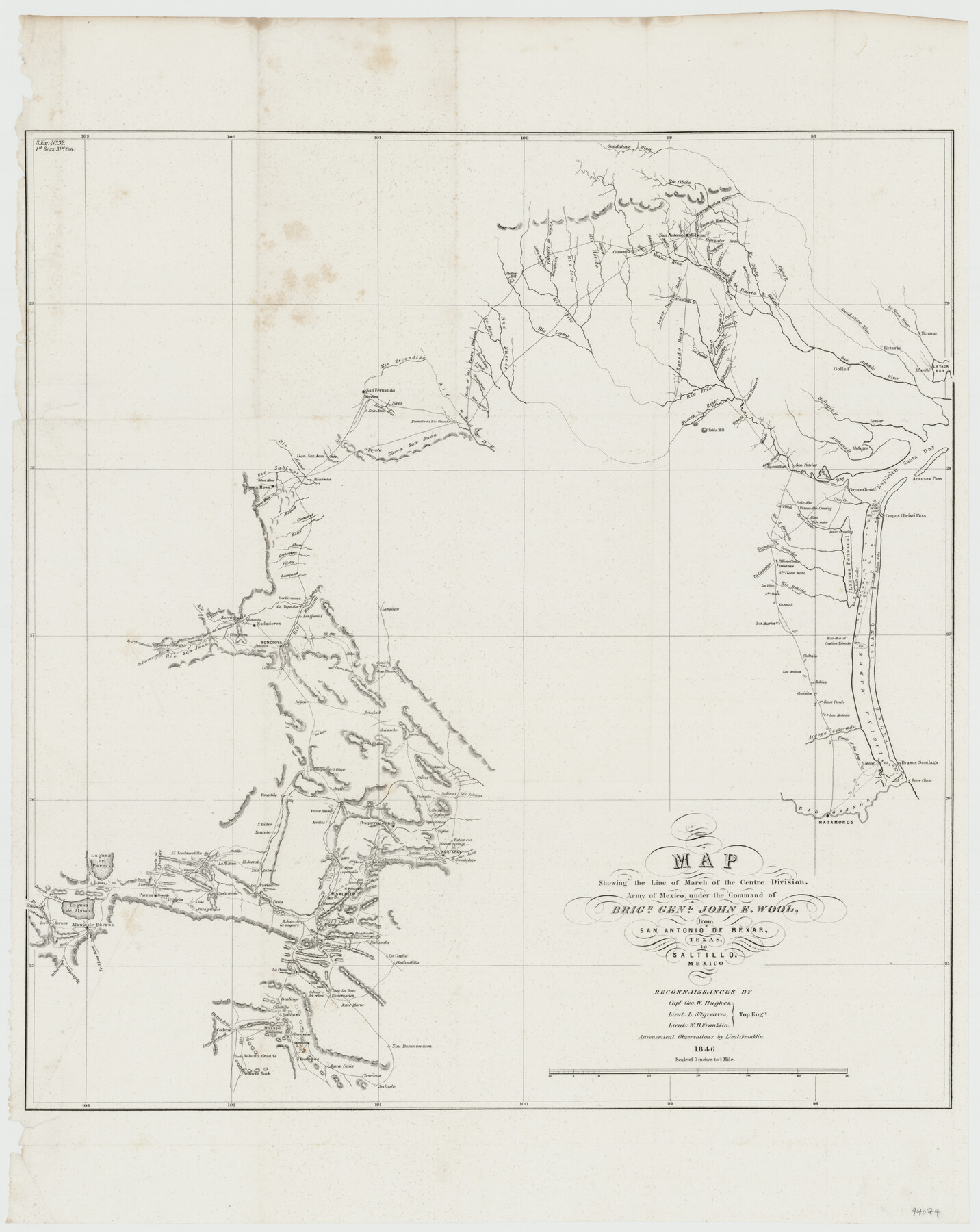
Map showing the line of march of the Centre Division, Army of Mexico, under the command of Brigr. Genl. John E. Wool, from San Antonio de Bexar, Texas to Saltillo, Mexico
-
Map/Doc
94074
-
Collection
General Map Collection
-
Object Dates
1846 (Creation Date)
-
People and Organizations
Geo. W. Hughes (Surveyor/Engineer)
L. Sitgreaves (Surveyor/Engineer)
W.B. Franklin (Surveyor/Engineer)
-
Subjects
Mexico Military
-
Height x Width
24.5 x 19.5 inches
62.2 x 49.5 cm
-
Medium
paper, etching/engraving/lithograph
-
Scale
5 inches to 1 mile
-
Comments
Astronomical Observations by Lieut. Franklin.
-
Features
Rio Grande
Boca Chica Pass
Brasos Santiago Pass
Point Isabel
Arroyo Colorado
Matamoros
Route of the Army
Los Mulatos
Laguna Madre
Padre Island
Saus Ponds
Carisitos Pond
Tahitos Pond
Los Animos Pond
Rancho of Gastine Tolendo
Los Muertos Pond
Encinal Pond
Santa Rosa Pond
La Pita
Rio Bobido
Santa Clara Motte
Laguna Penascal
Salt Lake
Belederos Pond
Pelican Ponds
[Road] to Camargo
Escondido Creek
Santa Gertrudis Creek
Rio San Fernando
Ague Dulce Creek
Indian Wells
Assan Crossing
Corpus Christi Pass
Palo Alto
Petronella Crossing
Almo Creek
Osa Creek
Los Pintos Creek
Aransas Pass
Espiritu Santo Bay
Refugio
Nueces Bay
San Patricio
Aransas River
Lamar
Refugio River
Lipantitlan
Casa Blanca Creek
Bass Creek
Cane Creek
Table Hill
Nueces River
Puente Piedras Creek
San Cristoval Creek
Rio Frio
Goliad
San Antonio River
Linville
Lavaca Bay
Victoria
Texana
Lavaca River
Guadalupe River
Chacanatilla Creek
Lepan Creek
Laha Creek
La Parita
Loredo [sic] Road
Lower Presidio Road
Boraga Creek
Cat Creek
Tortilla Creek
Atascosa River
Medina River
Road to Victoria & Goliad
Cieto River
Rio Cibolo
Marcelinas Creek
Gonzales Road
Leon Creek
Medio Creek
San Antonio de Bejar
Pinaritos Creek
Eagle Creek
Charpedra Creek
Calaverde Creek
Seguin Road
Salado Creek
Petrania Creek
Nacogdoches Road
Castroville
Ludy's Creek
Rio Hondo
Rio Seco
Rancheros Creek
Sabinal River
Canon River
Little Sabinal River
Padron Hill
Rio Leona
La Mina Creek
Route of the Centre Division
Saladina Creek
Picoso Creek
Chaparoso Creek
Las Cuevas Creek
Rio Escondido
San Fernando
Moretos
Nova
Santa Rita Creek
San Juan
Peyote
Sierra San Juan
Llan [sic] San Juan
Rio Alamo
Rio Sabinos
Silver Mine
Santa Rosa
Silver Mine Creek
Alamos Creek
Carecitos Creek
Saus Creek
Ahura Creek
Gachupina Creek
Piletes Creek
Part of: General Map Collection
Edwards County Working Sketch 17

Print $20.00
- Digital $50.00
Edwards County Working Sketch 17
1930
Size 32.3 x 26.8 inches
Map/Doc 68893
Swisher County Sketch File 9

Print $4.00
- Digital $50.00
Swisher County Sketch File 9
1916
Size 11.2 x 8.7 inches
Map/Doc 37629
Hudspeth County Sketch File 43

Print $10.00
- Digital $50.00
Hudspeth County Sketch File 43
1982
Size 14.3 x 8.9 inches
Map/Doc 27022
Live Oak County Working Sketch 13

Print $20.00
- Digital $50.00
Live Oak County Working Sketch 13
1957
Size 42.1 x 38.7 inches
Map/Doc 70598
Flight Mission No. DIX-5P, Frame 140, Aransas County

Print $20.00
- Digital $50.00
Flight Mission No. DIX-5P, Frame 140, Aransas County
1956
Size 17.8 x 18.5 inches
Map/Doc 83801
Kerr County Boundary File 4c

Print $4.00
- Digital $50.00
Kerr County Boundary File 4c
Size 3.7 x 12.3 inches
Map/Doc 64816
Wharton County Working Sketch 22

Print $20.00
- Digital $50.00
Wharton County Working Sketch 22
1919
Size 22.1 x 17.7 inches
Map/Doc 72486
Ward County Rolled Sketch 26

Print $28.00
- Digital $50.00
Ward County Rolled Sketch 26
Size 9.9 x 15.0 inches
Map/Doc 49468
Flight Mission No. BQR-4K, Frame 72, Brazoria County

Print $20.00
- Digital $50.00
Flight Mission No. BQR-4K, Frame 72, Brazoria County
1952
Size 18.8 x 22.5 inches
Map/Doc 84005
Terrell County Sketch File 35

Print $36.00
- Digital $50.00
Terrell County Sketch File 35
1957
Size 32.0 x 37.6 inches
Map/Doc 10389
Sutton County Working Sketch 3

Print $20.00
- Digital $50.00
Sutton County Working Sketch 3
1968
Size 23.6 x 34.5 inches
Map/Doc 62346
Engineer's Office, Department of the Gulf Map No. 59, Texas prepared by order of Maj. Gen. N. P. Banks under direction of Capt. P. C. Hains, U. S. Engr. & Chief Engr., Dept. of the Gulf

Print $20.00
- Digital $50.00
Engineer's Office, Department of the Gulf Map No. 59, Texas prepared by order of Maj. Gen. N. P. Banks under direction of Capt. P. C. Hains, U. S. Engr. & Chief Engr., Dept. of the Gulf
1865
Size 18.2 x 27.5 inches
Map/Doc 72716
You may also like
Louisiana and Texas Intracoastal Waterway

Print $20.00
- Digital $50.00
Louisiana and Texas Intracoastal Waterway
1929
Size 13.6 x 19.6 inches
Map/Doc 83342
Reeves County Rolled Sketch 1

Print $40.00
- Digital $50.00
Reeves County Rolled Sketch 1
Size 52.9 x 38.5 inches
Map/Doc 9844
Liberty County Working Sketch 78

Print $20.00
- Digital $50.00
Liberty County Working Sketch 78
1981
Size 36.2 x 41.0 inches
Map/Doc 70538
[Galveston, Harrisburg & San Antonio through El Paso County]
![64001, [Galveston, Harrisburg & San Antonio through El Paso County], General Map Collection](https://historictexasmaps.com/wmedia_w700/maps/64001.tif.jpg)
Print $20.00
- Digital $50.00
[Galveston, Harrisburg & San Antonio through El Paso County]
1907
Size 13.6 x 33.7 inches
Map/Doc 64001
Hockley County Sketch Mineral Applications Number 38322- 38379

Print $20.00
- Digital $50.00
Hockley County Sketch Mineral Applications Number 38322- 38379
1946
Size 33.5 x 27.9 inches
Map/Doc 92232
Neches River, Watershed of the Neches River

Print $6.00
- Digital $50.00
Neches River, Watershed of the Neches River
1925
Size 34.6 x 28.3 inches
Map/Doc 65085
Current Miscellaneous File 99

Print $32.00
- Digital $50.00
Current Miscellaneous File 99
1984
Size 11.2 x 8.7 inches
Map/Doc 74340
Hardin County Sketch File 19

Print $6.00
- Digital $50.00
Hardin County Sketch File 19
Size 13.0 x 10.9 inches
Map/Doc 25135
Presidio County Rolled Sketch 141

Print $20.00
- Digital $50.00
Presidio County Rolled Sketch 141
Size 40.8 x 28.6 inches
Map/Doc 89064
The Chief Justice County of Harrisburg. Lands in Conflict with Brazoria, Liberty Counties

Print $20.00
The Chief Justice County of Harrisburg. Lands in Conflict with Brazoria, Liberty Counties
2020
Size 17.5 x 21.7 inches
Map/Doc 96050
Morris County Working Sketch 3

Print $20.00
- Digital $50.00
Morris County Working Sketch 3
1958
Size 27.6 x 38.2 inches
Map/Doc 71202
[Blocks W and Z with tie lines]
![90451, [Blocks W and Z with tie lines], Twichell Survey Records](https://historictexasmaps.com/wmedia_w700/maps/90451-1.tif.jpg)
Print $20.00
- Digital $50.00
[Blocks W and Z with tie lines]
1949
Size 14.4 x 14.2 inches
Map/Doc 90451