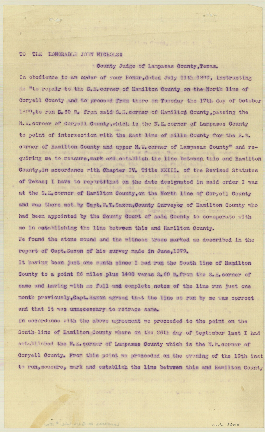
Lampasas County Boundary File 15a
A Correct Sketch of Lampasas & Hamilton County Line Showing Surveys Traversed, etc.
-
Map/Doc
56210
-
Collection
General Map Collection
-
Counties
Lampasas
-
Subjects
County Boundaries
-
Height x Width
13.3 x 8.2 inches
33.8 x 20.8 cm
Part of: General Map Collection
Kimble County Working Sketch 2

Print $20.00
- Digital $50.00
Kimble County Working Sketch 2
Size 20.6 x 17.9 inches
Map/Doc 70070
Parker County Sketch File 30

Print $4.00
- Digital $50.00
Parker County Sketch File 30
Size 6.4 x 7.0 inches
Map/Doc 33570
Territory served by the Galveston Bay Ports, Tex.

Print $20.00
- Digital $50.00
Territory served by the Galveston Bay Ports, Tex.
Size 17.1 x 16.0 inches
Map/Doc 97165
Reeves County Rolled Sketch 24

Print $20.00
- Digital $50.00
Reeves County Rolled Sketch 24
1982
Size 37.2 x 24.9 inches
Map/Doc 7493
Presidio County Working Sketch 99

Print $20.00
- Digital $50.00
Presidio County Working Sketch 99
1979
Size 26.8 x 39.8 inches
Map/Doc 71776
Colorado County Boundary File 1

Print $8.00
- Digital $50.00
Colorado County Boundary File 1
Size 14.0 x 8.6 inches
Map/Doc 51768
Somervell County

Print $20.00
- Digital $50.00
Somervell County
1884
Size 25.1 x 24.2 inches
Map/Doc 4042
Grayson County Boundary File 4a

Print $24.00
- Digital $50.00
Grayson County Boundary File 4a
Size 10.0 x 42.7 inches
Map/Doc 53956
Flight Mission No. BQR-13K, Frame 23, Brazoria County

Print $20.00
- Digital $50.00
Flight Mission No. BQR-13K, Frame 23, Brazoria County
1952
Size 18.9 x 22.4 inches
Map/Doc 84071
Map of San Jacinto County

Print $20.00
- Digital $50.00
Map of San Jacinto County
1879
Size 27.0 x 18.1 inches
Map/Doc 4624
Cochran County Working Sketch 2

Print $40.00
- Digital $50.00
Cochran County Working Sketch 2
1971
Size 52.9 x 45.3 inches
Map/Doc 68013
Hutchinson County Sketch File 43

Print $4.00
- Digital $50.00
Hutchinson County Sketch File 43
1891
Size 11.2 x 8.8 inches
Map/Doc 27309
You may also like
[Strip Map showing T. & P. connecting lines]
![93182, [Strip Map showing T. & P. connecting lines], Twichell Survey Records](https://historictexasmaps.com/wmedia_w700/maps/93182-1.tif.jpg)
Print $40.00
- Digital $50.00
[Strip Map showing T. & P. connecting lines]
Size 13.6 x 92.6 inches
Map/Doc 93182
Young County Sketch File 12

Print $4.00
- Digital $50.00
Young County Sketch File 12
1889
Size 8.5 x 13.6 inches
Map/Doc 40876
Hardin County Sketch File 71e

Print $20.00
- Digital $50.00
Hardin County Sketch File 71e
Size 25.2 x 37.1 inches
Map/Doc 11642
Flight Mission No. CUG-3P, Frame 159, Kleberg County

Print $20.00
- Digital $50.00
Flight Mission No. CUG-3P, Frame 159, Kleberg County
1956
Size 18.7 x 22.3 inches
Map/Doc 86279
King County Working Sketch 6

Print $20.00
- Digital $50.00
King County Working Sketch 6
1944
Size 11.5 x 18.3 inches
Map/Doc 70170
Harris County Rolled Sketch 26

Print $20.00
- Digital $50.00
Harris County Rolled Sketch 26
Size 28.2 x 41.3 inches
Map/Doc 6094
San Antonio of the 17th, 18th, and 19th Centuries: A Chronology of Her Romantic Past

San Antonio of the 17th, 18th, and 19th Centuries: A Chronology of Her Romantic Past
1929
Size 8.1 x 5.1 inches
Map/Doc 97044
[Sketch showing Blocks 2B, 3B, 3T, IT and 2]
![91843, [Sketch showing Blocks 2B, 3B, 3T, IT and 2], Twichell Survey Records](https://historictexasmaps.com/wmedia_w700/maps/91843-1.tif.jpg)
Print $20.00
- Digital $50.00
[Sketch showing Blocks 2B, 3B, 3T, IT and 2]
1918
Size 32.9 x 30.1 inches
Map/Doc 91843
Panola County Sketch File 30

Print $4.00
- Digital $50.00
Panola County Sketch File 30
1944
Size 2.8 x 8.9 inches
Map/Doc 33505
Garza County Rolled Sketch 6C

Print $20.00
- Digital $50.00
Garza County Rolled Sketch 6C
Size 24.7 x 19.2 inches
Map/Doc 5997
Mills County Working Sketch 9

Print $20.00
- Digital $50.00
Mills County Working Sketch 9
1915
Size 13.3 x 13.7 inches
Map/Doc 71039
General Highway Map, Lavaca County, Texas

Print $20.00
General Highway Map, Lavaca County, Texas
1940
Size 24.7 x 18.3 inches
Map/Doc 79170