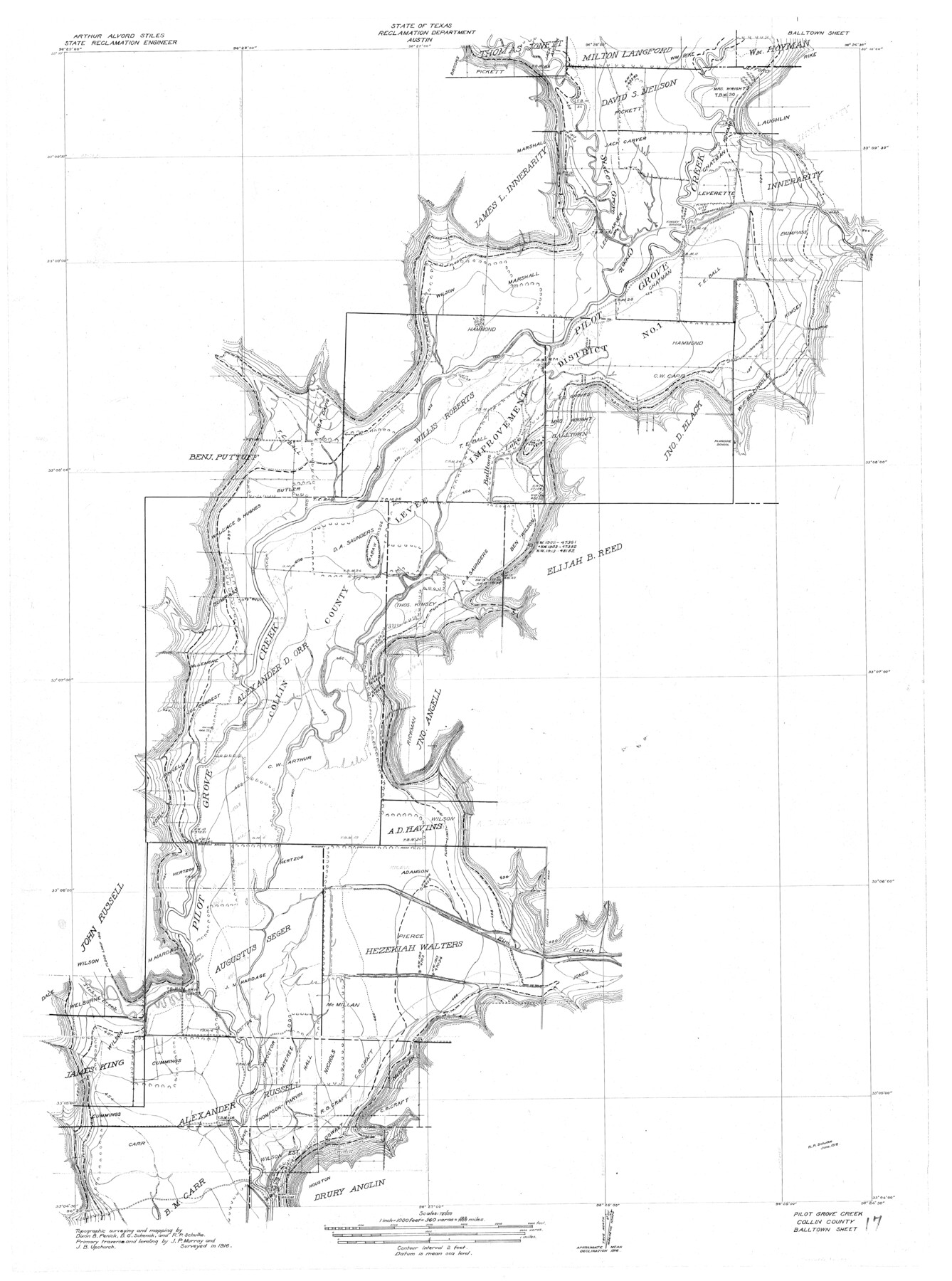
Trinity River, Balltown Sheet/Pilot Grove Creek
- 
                          Map/Doc
65195
 - 
                            Collection
General Map Collection
 - 
                            Object Dates
1916 (Creation Date)
 - 
                            People and Organizations
Texas State Reclamation Department (Publisher)
Dixon B. Penick (Surveyor/Engineer)
R.P. Schulke (Draftsman)
R.P. Schulke (Compiler)
B.G. Schenck (Surveyor/Engineer)
J.B. Upchurch (Surveyor/Engineer)
J.P. Murray (Surveyor/Engineer)
R.P. Schulke (Surveyor/Engineer)
 - 
                            Counties
Collin
 - 
                            Subjects
River Surveys Topographic
 - 
                            Height x Width
36.9 x 27.5 inches
93.7 x 69.9 cm
 - 
                            Comments
Balltown Sheet located north of the Clear Lake Sheet.
 
Part of: General Map Collection
            King County Sketch File 6


                                            Print $4.00                    
                                             -                         Digital $50.00                                    
                King County Sketch File 6
Size 14.4 x 8.8 inches
                                Map/Doc 29026
            
            Webb County Rolled Sketch 60


                                            Print $20.00                    
                                             -                         Digital $50.00                                    
                Webb County Rolled Sketch 60
1947
Size 30.0 x 33.8 inches
                                Map/Doc 8211
            
            Wichita County Working Sketch 9


                                            Print $20.00                    
                                             -                         Digital $50.00                                    
                Wichita County Working Sketch 9
1920
Size 23.7 x 17.6 inches
                                Map/Doc 72518
            
            Flight Mission No. DCL-7C, Frame 74, Kenedy County


                                            Print $20.00                    
                                             -                         Digital $50.00                                    
                Flight Mission No. DCL-7C, Frame 74, Kenedy County
1943
Size 15.4 x 15.1 inches
                                Map/Doc 86060
            
            Map of the southern states, including rail roads, county towns, state capitals, county roads, the southern coast from Delaware to Texas, showing the harbors, inlets, forts and position of blockading ships


                                            Print $20.00                    
                                             -                         Digital $50.00                                    
                Map of the southern states, including rail roads, county towns, state capitals, county roads, the southern coast from Delaware to Texas, showing the harbors, inlets, forts and position of blockading ships
1863
Size 22.1 x 32.3 inches
                                Map/Doc 96635
            
            Galveston County NRC Article 33.136 Sketch 7


                                            Print $20.00                    
                                             -                         Digital $50.00                                    
                Galveston County NRC Article 33.136 Sketch 7
2001
Size 23.7 x 37.2 inches
                                Map/Doc 61589
            
            Bowie County Sketch File 7a


                                            Print $30.00                    
                                             -                         Digital $50.00                                    
                Bowie County Sketch File 7a
1927
Size 11.2 x 8.7 inches
                                Map/Doc 14854
            
            Polk County Sketch File 9


                                            Print $28.00                    
                                             -                         Digital $50.00                                    
                Polk County Sketch File 9
1861
Size 11.9 x 7.7 inches
                                Map/Doc 34136
            
            Flight Mission No. BRE-1P, Frame 127, Nueces County


                                            Print $20.00                    
                                             -                         Digital $50.00                                    
                Flight Mission No. BRE-1P, Frame 127, Nueces County
1956
Size 18.7 x 22.6 inches
                                Map/Doc 86693
            
            Hutchinson County Sketch File 1


                                            Print $22.00                    
                                             -                         Digital $50.00                                    
                Hutchinson County Sketch File 1
Size 8.9 x 7.8 inches
                                Map/Doc 27172
            
            Runnels County Sketch File 10


                                            Print $46.00                    
                                    
                Runnels County Sketch File 10
1882
Size 7.3 x 8.2 inches
                                Map/Doc 35445
            
            King County Boundary File 4


                                            Print $58.00                    
                                             -                         Digital $50.00                                    
                King County Boundary File 4
Size 14.1 x 8.7 inches
                                Map/Doc 64905
            You may also like
            Map of Menard County


                                            Print $20.00                    
                                             -                         Digital $50.00                                    
                Map of Menard County
1894
Size 32.1 x 41.8 inches
                                Map/Doc 1320
            
            Hays County Sketch File 13 and 14


                                            Print $8.00                    
                                             -                         Digital $50.00                                    
                Hays County Sketch File 13 and 14
1868
Size 12.4 x 8.0 inches
                                Map/Doc 26220
            
            Van Zandt County Boundary File 2


                                            Print $32.00                    
                                             -                         Digital $50.00                                    
                Van Zandt County Boundary File 2
Size 13.0 x 8.1 inches
                                Map/Doc 59633
            
            Flight Mission No. BRA-9M, Frame 81, Jefferson County


                                            Print $20.00                    
                                             -                         Digital $50.00                                    
                Flight Mission No. BRA-9M, Frame 81, Jefferson County
1953
Size 18.3 x 22.6 inches
                                Map/Doc 85664
            
            Brazoria County Working Sketch 41


                                            Print $20.00                    
                                             -                         Digital $50.00                                    
                Brazoria County Working Sketch 41
1982
Size 26.5 x 35.7 inches
                                Map/Doc 67526
            
            Newton County Working Sketch 11


                                            Print $20.00                    
                                             -                         Digital $50.00                                    
                Newton County Working Sketch 11
1941
Size 22.7 x 23.5 inches
                                Map/Doc 71257
            
            Travis County Rolled Sketch 37


                                            Print $20.00                    
                                             -                         Digital $50.00                                    
                Travis County Rolled Sketch 37
1942
Size 33.6 x 32.7 inches
                                Map/Doc 10737
            
            Nueces County Sketch File 56


                                            Print $113.00                    
                                             -                         Digital $50.00                                    
                Nueces County Sketch File 56
1973
Size 10.1 x 9.3 inches
                                Map/Doc 32874
            
            Milam County Boundary File 3


                                            Print $16.00                    
                                             -                         Digital $50.00                                    
                Milam County Boundary File 3
Size 13.9 x 8.5 inches
                                Map/Doc 57213
            
            General Highway Map, Parmer County, Texas


                                            Print $20.00                    
                                    
                General Highway Map, Parmer County, Texas
1961
Size 18.1 x 24.4 inches
                                Map/Doc 79626
            
            [Surveys along Rabb's Creek]


                                            Print $2.00                    
                                             -                         Digital $50.00                                    
                [Surveys along Rabb's Creek]
1841
Size 8.7 x 11.0 inches
                                Map/Doc 154