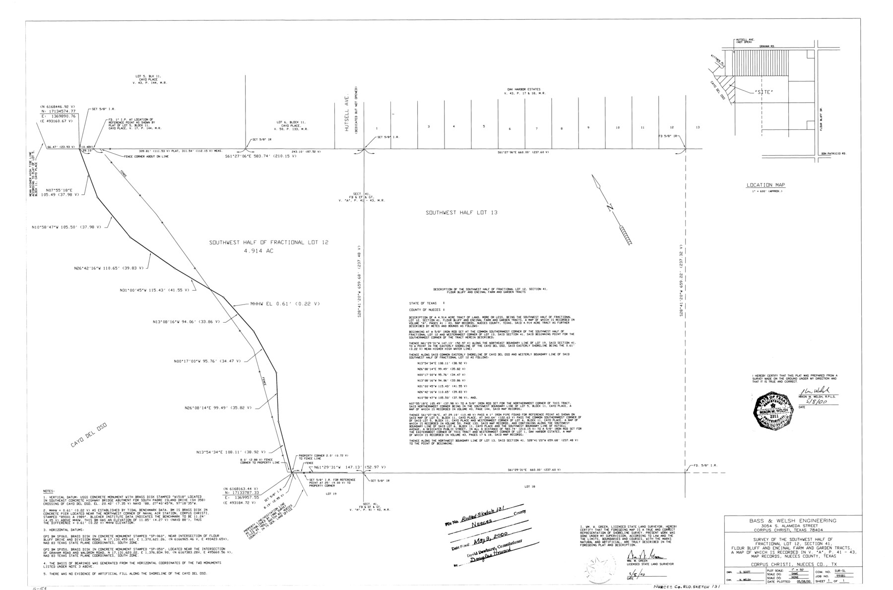
Nueces County Rolled Sketch 131
Survey of the southwest half of fractional lot 12, section 41, Flour Bluff and Encinal Farm and Garden Tracts
-
Map/Doc
7166
-
Collection
General Map Collection
-
Object Dates
2000/5/8 (Creation Date)
2000/5/9 (File Date)
-
People and Organizations
Nixon M. Welsh (Surveyor/Engineer)
S. Scott (Draftsman)
Wm. W. Green (Surveyor/Engineer)
-
Counties
Nueces
-
Subjects
Surveying Rolled Sketch
-
Height x Width
24.2 x 36.6 inches
61.5 x 93.0 cm
-
Medium
mylar, print
-
Scale
1" = 50 feet
-
Comments
See Nueces County Sketch File 82 (33165) for correspondence.
Related maps
Nueces County Sketch File 82

Print $4.00
- Digital $50.00
Nueces County Sketch File 82
2000
Size 11.0 x 8.8 inches
Map/Doc 33165
Part of: General Map Collection
Brazoria County Working Sketch 50a

Print $20.00
- Digital $50.00
Brazoria County Working Sketch 50a
2003
Size 35.0 x 35.2 inches
Map/Doc 78344
Martin County Working Sketch 10

Print $40.00
- Digital $50.00
Martin County Working Sketch 10
1971
Size 50.0 x 37.4 inches
Map/Doc 70828
Coryell County Sketch File 23

Print $24.00
- Digital $50.00
Coryell County Sketch File 23
1948
Size 11.2 x 8.8 inches
Map/Doc 19387
Flight Mission No. DAH-9M, Frame 200, Orange County

Print $20.00
- Digital $50.00
Flight Mission No. DAH-9M, Frame 200, Orange County
1953
Size 18.6 x 22.4 inches
Map/Doc 86868
Sutton County Working Sketch 37

Print $20.00
- Digital $50.00
Sutton County Working Sketch 37
1947
Size 31.0 x 41.4 inches
Map/Doc 62380
Flight Mission No. BRA-16M, Frame 142, Jefferson County

Print $20.00
- Digital $50.00
Flight Mission No. BRA-16M, Frame 142, Jefferson County
1953
Size 18.5 x 22.2 inches
Map/Doc 85748
Map of Cameron County

Print $40.00
- Digital $50.00
Map of Cameron County
1895
Size 48.9 x 28.9 inches
Map/Doc 4901
Galveston County Aerial Photograph Index Sheet 1

Print $20.00
- Digital $50.00
Galveston County Aerial Photograph Index Sheet 1
1953
Size 23.4 x 19.2 inches
Map/Doc 83692
[Field book of Martin Duval, Wilbarger Co., H&TC RR Co. Blocks 13 & 14]
![61431, [Field book of Martin Duval, Wilbarger Co., H&TC RR Co. Blocks 13 & 14], General Map Collection](https://historictexasmaps.com/wmedia_w700/pdf_converted_jpg/qi_pdf_thumbnail_17161.jpg)
[Field book of Martin Duval, Wilbarger Co., H&TC RR Co. Blocks 13 & 14]
Size 6.7 x 8.2 inches
Map/Doc 61431
Rusk County Sketch File 39

Print $6.00
Rusk County Sketch File 39
1951
Size 11.3 x 8.9 inches
Map/Doc 35579
Kimble County Working Sketch 57

Print $20.00
- Digital $50.00
Kimble County Working Sketch 57
1958
Size 20.3 x 30.5 inches
Map/Doc 70125
Montgomery County Rolled Sketch 18

Print $40.00
- Digital $50.00
Montgomery County Rolled Sketch 18
Size 51.4 x 25.3 inches
Map/Doc 9528
You may also like
Polk County Working Sketch 24

Print $20.00
- Digital $50.00
Polk County Working Sketch 24
1957
Size 24.8 x 25.3 inches
Map/Doc 71640
Lamb County Rolled Sketch 8

Print $20.00
- Digital $50.00
Lamb County Rolled Sketch 8
1910
Size 40.1 x 32.8 inches
Map/Doc 10728
Taylor County Working Sketch Graphic Index

Print $20.00
- Digital $50.00
Taylor County Working Sketch Graphic Index
1934
Size 42.8 x 36.4 inches
Map/Doc 76709
Harbor of Brazos Santiago, Texas

Print $20.00
- Digital $50.00
Harbor of Brazos Santiago, Texas
1887
Size 27.3 x 18.3 inches
Map/Doc 72992
Andrews County Working Sketch 18

Print $20.00
- Digital $50.00
Andrews County Working Sketch 18
1964
Size 42.2 x 26.5 inches
Map/Doc 67064
Reagan County Rolled Sketch 6

Print $20.00
- Digital $50.00
Reagan County Rolled Sketch 6
Size 17.8 x 17.3 inches
Map/Doc 7435
Amherst Suburban Farms

Print $20.00
- Digital $50.00
Amherst Suburban Farms
Size 16.7 x 16.8 inches
Map/Doc 92265
El Paso County Sketch File 14

Print $20.00
- Digital $50.00
El Paso County Sketch File 14
1922
Size 24.0 x 17.2 inches
Map/Doc 11452
Overlay For BRE-1P, Frame 153 of Refugio Scrip 1930, Nueces County

Print $20.00
- Digital $50.00
Overlay For BRE-1P, Frame 153 of Refugio Scrip 1930, Nueces County
1956
Size 18.8 x 22.6 inches
Map/Doc 86713
Leon County, Texas

Print $20.00
- Digital $50.00
Leon County, Texas
1879
Size 25.6 x 22.3 inches
Map/Doc 563
Presidio County Sketch File 45

Print $6.00
- Digital $50.00
Presidio County Sketch File 45
1914
Size 11.3 x 8.8 inches
Map/Doc 34532
Llano County Sketch File 8

Print $10.00
- Digital $50.00
Llano County Sketch File 8
1885
Size 14.1 x 8.8 inches
Map/Doc 30364