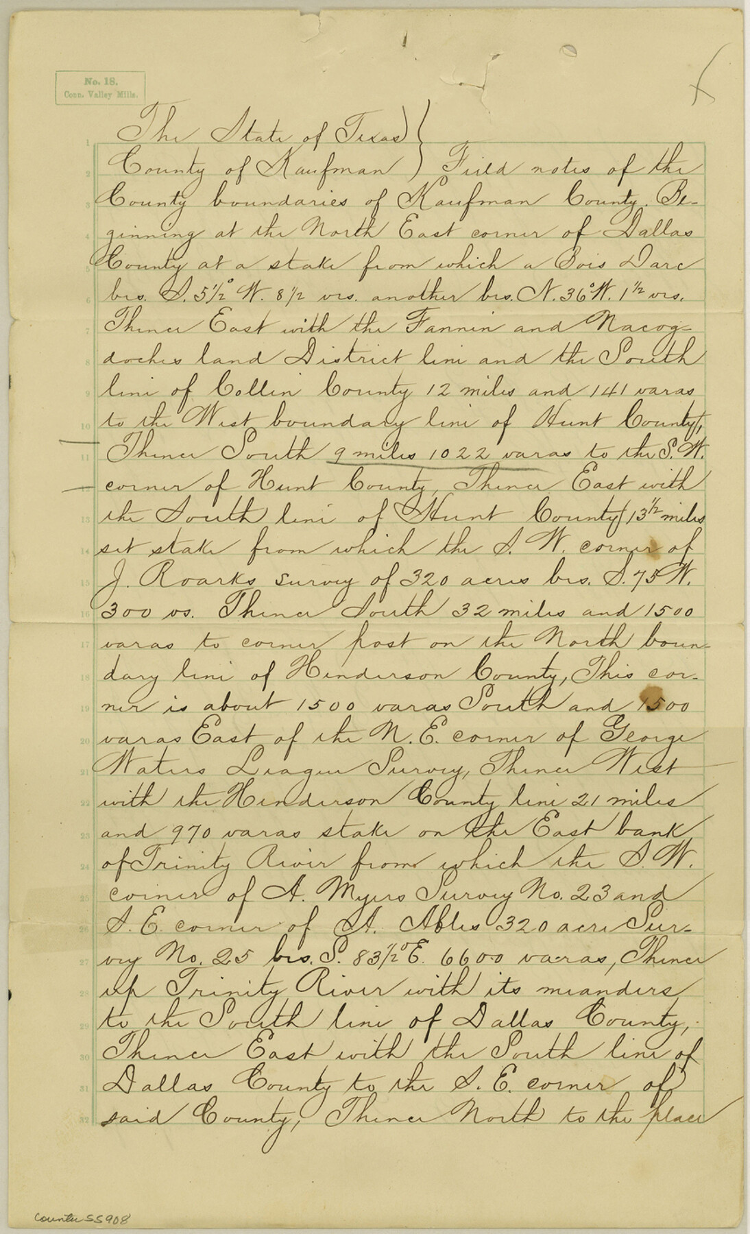
Kaufman County Boundary File 1a
Original field notes of Kaufman County
-
Map/Doc
55907
-
Collection
General Map Collection
-
Counties
Kaufman
-
Subjects
County Boundaries
-
Height x Width
14.1 x 8.6 inches
35.8 x 21.8 cm
Part of: General Map Collection
Flight Mission No. DIX-8P, Frame 60, Aransas County

Print $20.00
- Digital $50.00
Flight Mission No. DIX-8P, Frame 60, Aransas County
1956
Size 18.5 x 22.2 inches
Map/Doc 83891
Flight Mission No. DCL-7C, Frame 134, Kenedy County

Print $20.00
- Digital $50.00
Flight Mission No. DCL-7C, Frame 134, Kenedy County
1943
Size 18.5 x 22.3 inches
Map/Doc 86091
Winkler County Rolled Sketch 11

Print $20.00
- Digital $50.00
Winkler County Rolled Sketch 11
1965
Size 37.4 x 34.2 inches
Map/Doc 10152
Bandera County

Print $40.00
- Digital $50.00
Bandera County
1947
Size 33.9 x 54.9 inches
Map/Doc 73075
Flight Mission No. BQY-4M, Frame 38, Harris County

Print $20.00
- Digital $50.00
Flight Mission No. BQY-4M, Frame 38, Harris County
1953
Size 18.6 x 22.4 inches
Map/Doc 85253
Flight Mission No. DIX-5P, Frame 144, Aransas County

Print $20.00
- Digital $50.00
Flight Mission No. DIX-5P, Frame 144, Aransas County
1956
Size 17.2 x 17.6 inches
Map/Doc 83805
Amistad International Reservoir on Rio Grande 77

Print $20.00
- Digital $50.00
Amistad International Reservoir on Rio Grande 77
1949
Size 28.5 x 40.2 inches
Map/Doc 75505
Nolan County Boundary File 1

Print $60.00
- Digital $50.00
Nolan County Boundary File 1
Size 8.8 x 3.9 inches
Map/Doc 57617
Harris County Historic Topographic 6

Print $20.00
- Digital $50.00
Harris County Historic Topographic 6
1916
Size 29.9 x 22.8 inches
Map/Doc 65816
Flight Mission No. DQN-2K, Frame 90, Calhoun County

Print $20.00
- Digital $50.00
Flight Mission No. DQN-2K, Frame 90, Calhoun County
1953
Size 18.4 x 22.3 inches
Map/Doc 84280
[Galveston, Harrisburg & San Antonio Railway]
![64404, [Galveston, Harrisburg & San Antonio Railway], General Map Collection](https://historictexasmaps.com/wmedia_w700/maps/64404.tif.jpg)
Print $20.00
- Digital $50.00
[Galveston, Harrisburg & San Antonio Railway]
1892
Size 13.8 x 34.0 inches
Map/Doc 64404
Hardin County Working Sketch 8

Print $20.00
- Digital $50.00
Hardin County Working Sketch 8
1926
Size 16.5 x 21.0 inches
Map/Doc 63406
You may also like
Frio County Sketch File 5

Print $4.00
- Digital $50.00
Frio County Sketch File 5
1878
Size 7.9 x 11.2 inches
Map/Doc 23116
San Patricio County Rolled Sketch 7A

Print $20.00
- Digital $50.00
San Patricio County Rolled Sketch 7A
1870
Size 46.8 x 27.3 inches
Map/Doc 9884
Kerr County Rolled Sketch 16

Print $20.00
- Digital $50.00
Kerr County Rolled Sketch 16
1951
Size 40.6 x 31.1 inches
Map/Doc 9346
Callahan County Working Sketch 4

Print $20.00
- Digital $50.00
Callahan County Working Sketch 4
1953
Size 17.1 x 27.0 inches
Map/Doc 67886
Mexico, Texas und Californien

Print $20.00
- Digital $50.00
Mexico, Texas und Californien
1855
Size 22.7 x 28.0 inches
Map/Doc 93651
Rusk County Working Sketch 21

Print $20.00
- Digital $50.00
Rusk County Working Sketch 21
1953
Size 27.6 x 28.3 inches
Map/Doc 63657
Flight Mission No. BRE-1P, Frame 153, Nueces County

Print $20.00
- Digital $50.00
Flight Mission No. BRE-1P, Frame 153, Nueces County
1956
Size 18.5 x 22.5 inches
Map/Doc 86714
Duval County Working Sketch 43

Print $20.00
- Digital $50.00
Duval County Working Sketch 43
1977
Size 30.8 x 30.5 inches
Map/Doc 68767

Refugio County NRC Article 33.136 Location Key Sheet

Print $20.00
- Digital $50.00
Refugio County NRC Article 33.136 Location Key Sheet
1979
Size 27.3 x 24.0 inches
Map/Doc 88584
Plat Showing Land Owned by City of Lubbock out of Section 3, Block O

Print $20.00
- Digital $50.00
Plat Showing Land Owned by City of Lubbock out of Section 3, Block O
Size 40.4 x 31.1 inches
Map/Doc 92876
Bailey County Rolled Sketch 3

Print $20.00
- Digital $50.00
Bailey County Rolled Sketch 3
1913
Size 15.2 x 13.8 inches
Map/Doc 5110