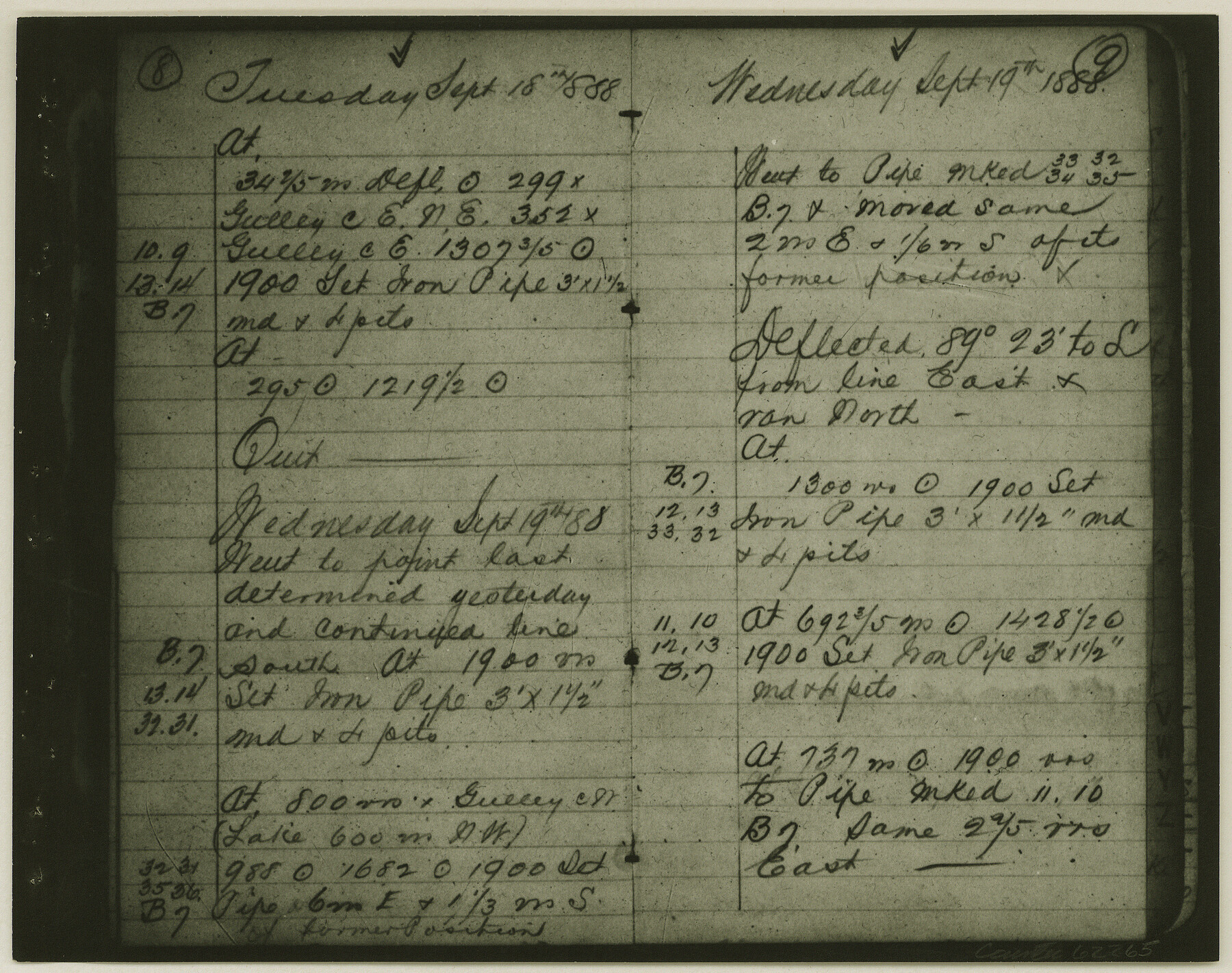
Copy of Surveyor's Field Book, Morris Browning - In Blocks 7, 5 & 4, I&GNRRCo., Hutchinson and Carson Counties, Texas
K-7-70
-
Map/Doc
62265
-
Collection
General Map Collection
-
Object Dates
1888/10/22 (Creation Date)
-
People and Organizations
Morris Browning (Surveyor/Engineer)
-
Counties
Hutchinson Carson
-
Height x Width
7.0 x 8.8 inches
17.8 x 22.4 cm
-
Comments
Copy of Surveyor's field book presented to the General Land Office by Morris Browning on February 3, 1941.
Surveyed from September 14, 1888 to October 22, 1888.
Part of: General Map Collection
Hardin County Sketch File 9

Print $4.00
- Digital $50.00
Hardin County Sketch File 9
1865
Size 12.4 x 8.2 inches
Map/Doc 25106
Haskell County Working Sketch 2

Print $3.00
- Digital $50.00
Haskell County Working Sketch 2
1914
Size 14.9 x 10.1 inches
Map/Doc 66060
Shelby County Working Sketch 7

Print $20.00
- Digital $50.00
Shelby County Working Sketch 7
1942
Size 40.2 x 44.2 inches
Map/Doc 63860
Map of Galveston Harbor and City

Print $40.00
- Digital $50.00
Map of Galveston Harbor and City
1850
Size 31.0 x 52.0 inches
Map/Doc 69856
San Patricio County Sketch File 31

Print $6.00
- Digital $50.00
San Patricio County Sketch File 31
Size 14.0 x 10.0 inches
Map/Doc 36117
Map of Val Verde County

Print $40.00
- Digital $50.00
Map of Val Verde County
1898
Size 80.7 x 42.7 inches
Map/Doc 16913
[Surveys along the Colorado River]
![112, [Surveys along the Colorado River], General Map Collection](https://historictexasmaps.com/wmedia_w700/maps/112.tif.jpg)
Print $2.00
- Digital $50.00
[Surveys along the Colorado River]
1841
Size 12.2 x 8.3 inches
Map/Doc 112
Jefferson County Working Sketch 38

Print $20.00
- Digital $50.00
Jefferson County Working Sketch 38
1984
Size 32.6 x 43.2 inches
Map/Doc 66582
Flight Mission No. CRE-1R, Frame 121, Jackson County

Print $20.00
- Digital $50.00
Flight Mission No. CRE-1R, Frame 121, Jackson County
1956
Size 16.2 x 16.0 inches
Map/Doc 85332
Dallas County Working Sketch 4

Print $20.00
- Digital $50.00
Dallas County Working Sketch 4
1935
Size 24.1 x 30.4 inches
Map/Doc 68570
Rusk County Working Sketch 15

Print $20.00
- Digital $50.00
Rusk County Working Sketch 15
1972
Size 29.6 x 43.8 inches
Map/Doc 63650
Wharton County Working Sketch 17

Print $20.00
- Digital $50.00
Wharton County Working Sketch 17
1951
Size 36.1 x 24.2 inches
Map/Doc 72481
You may also like

Texas Boundary Line

Print $20.00
- Digital $50.00
Texas Boundary Line
Size 21.6 x 11.9 inches
Map/Doc 92078
Terrell County Working Sketch 76

Print $20.00
- Digital $50.00
Terrell County Working Sketch 76
1982
Size 31.8 x 20.1 inches
Map/Doc 69597
Comanche County Sketch File 18

Print $4.00
- Digital $50.00
Comanche County Sketch File 18
Size 8.4 x 7.8 inches
Map/Doc 19091
County Map of Texas and Indian Territory

Print $20.00
- Digital $50.00
County Map of Texas and Indian Territory
1881
Size 13.1 x 9.9 inches
Map/Doc 94153
Presidio County Sketch File 110

Print $12.00
- Digital $50.00
Presidio County Sketch File 110
1886
Size 12.3 x 8.5 inches
Map/Doc 34818
Coast Chart No. 211 - Padre I. and Laguna Madre Lat. 27° 12' to Lat. 26° 33' Texas

Print $20.00
- Digital $50.00
Coast Chart No. 211 - Padre I. and Laguna Madre Lat. 27° 12' to Lat. 26° 33' Texas
1890
Size 27.2 x 18.2 inches
Map/Doc 72821
Map of San Patricio County

Print $40.00
- Digital $50.00
Map of San Patricio County
1896
Size 31.6 x 51.2 inches
Map/Doc 63018
General Highway Map, Burleson County, Texas

Print $20.00
General Highway Map, Burleson County, Texas
1961
Size 18.1 x 24.8 inches
Map/Doc 79391
Val Verde County Working Sketch 104

Print $20.00
- Digital $50.00
Val Verde County Working Sketch 104
1982
Size 26.4 x 19.0 inches
Map/Doc 72239
Tyler County Sketch File 30

Print $4.00
- Digital $50.00
Tyler County Sketch File 30
1989
Size 14.3 x 8.8 inches
Map/Doc 38721
Hopkins County Sketch File 12

Print $6.00
- Digital $50.00
Hopkins County Sketch File 12
Size 6.8 x 8.1 inches
Map/Doc 26706