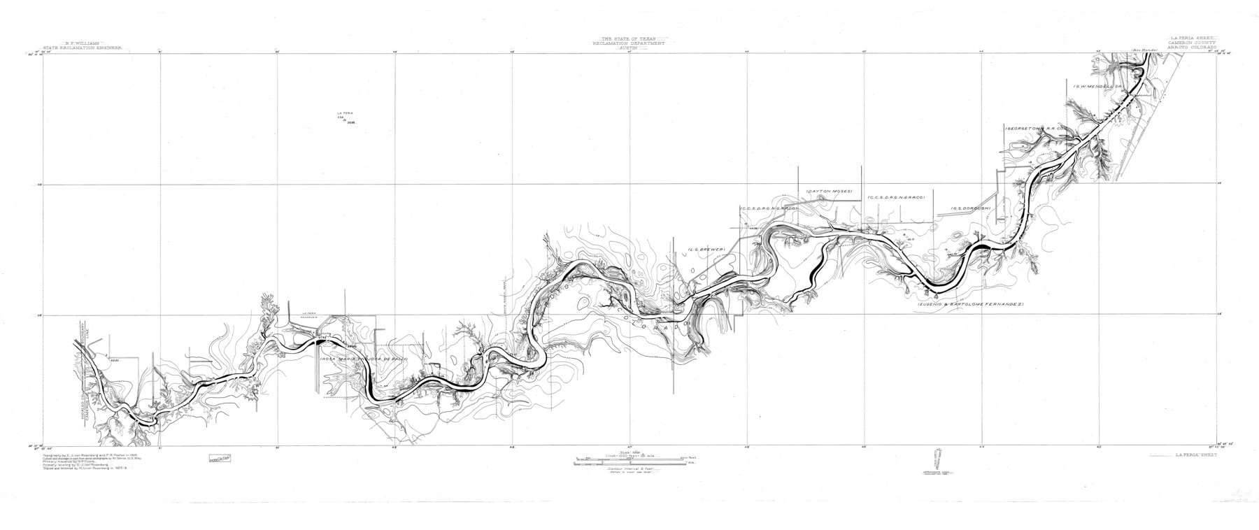
Arroyo Colorado, La Feria Sheet
-
Map/Doc
65128
-
Collection
General Map Collection
-
Object Dates
1929 (Creation Date)
-
People and Organizations
Texas State Reclamation Department (Publisher)
H.U. von Rosenberg (Compiler)
H.U. von Rosenberg (Draftsman)
S.P. Floore (Surveyor/Engineer)
F.R. Poston (Surveyor/Engineer)
E.J. von Rosenberg (Surveyor/Engineer)
-
Counties
Cameron
-
Subjects
River Surveys Topographic
-
Height x Width
24.6 x 58.5 inches
62.5 x 148.6 cm
-
Comments
Arroyo Colorado flows into the Laguna Madre.
La Feria Sheet located south of the Rio Hondo Sheet.
Part of: General Map Collection
Levee Improvement Districts Width of Floodways - South Sulphur River

Print $6.00
- Digital $50.00
Levee Improvement Districts Width of Floodways - South Sulphur River
1918
Size 19.6 x 34.1 inches
Map/Doc 65175
Nueces County Sketch File 74

Print $28.00
- Digital $50.00
Nueces County Sketch File 74
1951
Size 10.1 x 15.4 inches
Map/Doc 33028
Freestone County Working Sketch Graphic Index

Print $20.00
- Digital $50.00
Freestone County Working Sketch Graphic Index
1988
Size 43.0 x 42.1 inches
Map/Doc 76547
Nolan County Sketch File 14

Print $20.00
- Digital $50.00
Nolan County Sketch File 14
1927
Size 32.6 x 20.0 inches
Map/Doc 42164

Map of Travis County

Print $40.00
- Digital $50.00
Map of Travis County
1894
Size 49.8 x 58.8 inches
Map/Doc 16904
Bandera County Working Sketch 55

Print $20.00
- Digital $50.00
Bandera County Working Sketch 55
1990
Size 34.4 x 42.1 inches
Map/Doc 67651
[Sketch for Mineral Application 24072, San Jacinto River]
![65606, [Sketch for Mineral Application 24072, San Jacinto River], General Map Collection](https://historictexasmaps.com/wmedia_w700/maps/65606.tif.jpg)
Print $20.00
- Digital $50.00
[Sketch for Mineral Application 24072, San Jacinto River]
1929
Size 23.2 x 17.8 inches
Map/Doc 65606
Johnson County Working Sketch 4

Print $20.00
- Digital $50.00
Johnson County Working Sketch 4
1948
Size 26.5 x 24.6 inches
Map/Doc 66617
Hutchinson County Working Sketch 41

Print $20.00
- Digital $50.00
Hutchinson County Working Sketch 41
1978
Size 26.8 x 22.3 inches
Map/Doc 66401
Starr County Rolled Sketch 42

Print $20.00
- Digital $50.00
Starr County Rolled Sketch 42
1972
Size 26.0 x 18.4 inches
Map/Doc 7835
Flight Mission No. CLL-1N, Frame 109, Willacy County

Print $20.00
- Digital $50.00
Flight Mission No. CLL-1N, Frame 109, Willacy County
1954
Size 18.3 x 22.1 inches
Map/Doc 87043
You may also like
James Subdivision, NE/4 Section 1, Block E, G. C. & S. F. R.R. Co. Cert 3/360, Abstract 46

Print $3.00
- Digital $50.00
James Subdivision, NE/4 Section 1, Block E, G. C. & S. F. R.R. Co. Cert 3/360, Abstract 46
Size 11.0 x 12.2 inches
Map/Doc 92705
Duval County Sketch File 33

Print $55.00
- Digital $50.00
Duval County Sketch File 33
1932
Size 14.4 x 8.8 inches
Map/Doc 21342
Lampasas County Sketch File 21

Print $14.00
- Digital $50.00
Lampasas County Sketch File 21
2001
Size 14.2 x 8.8 inches
Map/Doc 29436
Jefferson County Working Sketch 37

Print $40.00
- Digital $50.00
Jefferson County Working Sketch 37
1982
Size 49.9 x 36.6 inches
Map/Doc 66581
[Sketch for Mineral Application 27670 - Strip between Simon Sanchez leagues and Trinity River]
![2864, [Sketch for Mineral Application 27670 - Strip between Simon Sanchez leagues and Trinity River], General Map Collection](https://historictexasmaps.com/wmedia_w700/maps/2864-1.tif.jpg)
Print $20.00
- Digital $50.00
[Sketch for Mineral Application 27670 - Strip between Simon Sanchez leagues and Trinity River]
1934
Size 17.2 x 31.7 inches
Map/Doc 2864
Rockwall County Sketch File 4

Print $9.00
Rockwall County Sketch File 4
1860
Size 7.7 x 12.1 inches
Map/Doc 35419
Williamson County Sketch File 12

Print $4.00
- Digital $50.00
Williamson County Sketch File 12
1860
Size 12.6 x 3.4 inches
Map/Doc 40326
Real County Rolled Sketch 18

Print $20.00
- Digital $50.00
Real County Rolled Sketch 18
Size 22.0 x 28.0 inches
Map/Doc 7464
[Surveying Sketch of W.B. Tatum, Wm. B. Jordan, et al]
![428, [Surveying Sketch of W.B. Tatum, Wm. B. Jordan, et al], Maddox Collection](https://historictexasmaps.com/wmedia_w700/maps/0428.tif.jpg)
Print $2.00
- Digital $50.00
[Surveying Sketch of W.B. Tatum, Wm. B. Jordan, et al]
Size 8.9 x 10.8 inches
Map/Doc 428
Map of the South West Railway System - Missouri Pacific Ry., Central Branch U.P. R.R., Missouri, Kansas & Texas Ry., Texas and Pacific Ry., St. Louis, Iron Mountn. and Southern Ry., International and Great Northern Ry., and their connections

Print $20.00
- Digital $50.00
Map of the South West Railway System - Missouri Pacific Ry., Central Branch U.P. R.R., Missouri, Kansas & Texas Ry., Texas and Pacific Ry., St. Louis, Iron Mountn. and Southern Ry., International and Great Northern Ry., and their connections
1883
Size 15.8 x 21.2 inches
Map/Doc 95788
Wise County Rolled Sketch 2

Print $40.00
- Digital $50.00
Wise County Rolled Sketch 2
1941
Size 58.7 x 44.8 inches
Map/Doc 10155
Map of Yoakum County

Print $20.00
- Digital $50.00
Map of Yoakum County
1902
Size 47.2 x 35.3 inches
Map/Doc 16934