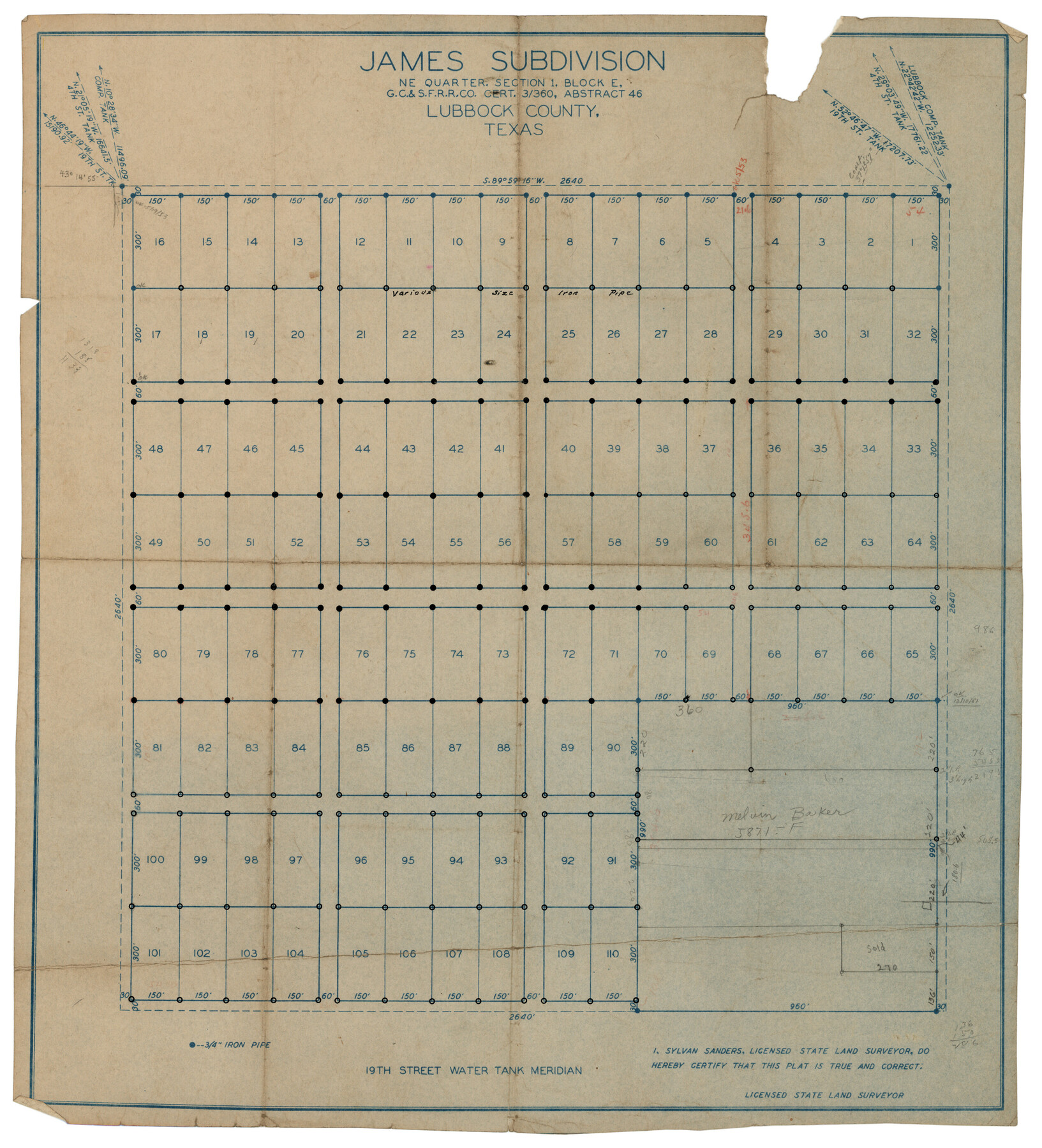
James Subdivision, NE/4 Section 1, Block E, G. C. & S. F. R.R. Co. Cert 3/360, Abstract 46
-
Map/Doc
92705
-
Collection
Twichell Survey Records
-
People and Organizations
Sylvan Sanders (Surveyor/Engineer)
-
Counties
Lubbock
-
Height x Width
11.0 x 12.2 inches
27.9 x 31.0 cm
Part of: Twichell Survey Records
Wm. D. Green's Subdivision of Part of Leagues 1,2,3, and 4 Wilson County School Land

Print $20.00
- Digital $50.00
Wm. D. Green's Subdivision of Part of Leagues 1,2,3, and 4 Wilson County School Land
Size 16.5 x 19.4 inches
Map/Doc 92959
Map of Young County

Print $20.00
- Digital $50.00
Map of Young County
Size 16.9 x 19.7 inches
Map/Doc 92108
[Strip map showing F. W. & D. C. RR. line from New Mexico border to Dallam-Hartley County Line]
![93147, [Strip map showing F. W. & D. C. RR. line from New Mexico border to Dallam-Hartley County Line], Twichell Survey Records](https://historictexasmaps.com/wmedia_w700/maps/93147-1.tif.jpg)
Print $40.00
- Digital $50.00
[Strip map showing F. W. & D. C. RR. line from New Mexico border to Dallam-Hartley County Line]
Size 105.5 x 20.9 inches
Map/Doc 93147
Map of Escarpment Section through Webb County, Texas (South half of Webb County)

Print $40.00
- Digital $50.00
Map of Escarpment Section through Webb County, Texas (South half of Webb County)
1925
Size 43.3 x 76.2 inches
Map/Doc 93163
Robertson V Ranch

Print $20.00
- Digital $50.00
Robertson V Ranch
Size 41.7 x 46.0 inches
Map/Doc 89756

The Texas Co-Ordinate System, Title 86 Article 5300A.

Print $20.00
- Digital $50.00
The Texas Co-Ordinate System, Title 86 Article 5300A.
Size 30.8 x 28.4 inches
Map/Doc 92824
Jno. B. Slaughter US Ranch situated in Garza County, Texas

Print $40.00
- Digital $50.00
Jno. B. Slaughter US Ranch situated in Garza County, Texas
Size 34.6 x 49.2 inches
Map/Doc 89946
Map of Bravo Ranch

Print $20.00
- Digital $50.00
Map of Bravo Ranch
Size 14.5 x 16.8 inches
Map/Doc 90690
Zavalla County School Land Hockley County, Texas

Print $20.00
- Digital $50.00
Zavalla County School Land Hockley County, Texas
1956
Size 41.6 x 20.2 inches
Map/Doc 92254
Survey Map of Runnels County

Print $20.00
- Digital $50.00
Survey Map of Runnels County
Size 33.6 x 40.3 inches
Map/Doc 92918
[Block 30 - Jasper Hays]
![92949, [Block 30 - Jasper Hays], Twichell Survey Records](https://historictexasmaps.com/wmedia_w700/maps/92949-1.tif.jpg)
Print $20.00
- Digital $50.00
[Block 30 - Jasper Hays]
Size 25.8 x 17.8 inches
Map/Doc 92949
You may also like
Edwards County Sketch File 18

Print $6.00
- Digital $50.00
Edwards County Sketch File 18
Size 16.3 x 10.6 inches
Map/Doc 21738
Map of Chicago, Rock Island & Texas Railway

Print $20.00
- Digital $50.00
Map of Chicago, Rock Island & Texas Railway
1892
Size 22.4 x 44.0 inches
Map/Doc 64443
Right of Way and Track Map Houston & Texas Central R.R. operated by the T. and N. O. R.R. Co., Fort Worth Branch

Print $40.00
- Digital $50.00
Right of Way and Track Map Houston & Texas Central R.R. operated by the T. and N. O. R.R. Co., Fort Worth Branch
1918
Size 31.4 x 58.5 inches
Map/Doc 64544
History of Texas from its First Settlement in 1685 to its Annexation to the United States in 1846 (Vol. 1)

History of Texas from its First Settlement in 1685 to its Annexation to the United States in 1846 (Vol. 1)
1856
Map/Doc 97390
Index to the following sixteen sheets, being a compleat chart of the West Indies with letters in the margin to direct the placing of the different sheets in their proper places

Print $20.00
- Digital $50.00
Index to the following sixteen sheets, being a compleat chart of the West Indies with letters in the margin to direct the placing of the different sheets in their proper places
Size 21.5 x 28.6 inches
Map/Doc 96440
Freestone County Working Sketch 26

Print $20.00
- Digital $50.00
Freestone County Working Sketch 26
1907
Size 27.7 x 30.3 inches
Map/Doc 69268
[Block 1 Showing County Seat]
![92951, [Block 1 Showing County Seat], Twichell Survey Records](https://historictexasmaps.com/wmedia_w700/maps/92951-1.tif.jpg)
Print $20.00
- Digital $50.00
[Block 1 Showing County Seat]
Size 20.8 x 12.3 inches
Map/Doc 92951
Sketch Terrell and Val Verde Counties

Print $20.00
- Digital $50.00
Sketch Terrell and Val Verde Counties
1932
Size 41.2 x 18.2 inches
Map/Doc 92800
Galveston County NRC Article 33.136 Sketch 56

Print $42.00
- Digital $50.00
Galveston County NRC Article 33.136 Sketch 56
2009
Size 22.0 x 34.0 inches
Map/Doc 94733
Baylor County Sketch File 30

Print $14.00
- Digital $50.00
Baylor County Sketch File 30
Size 11.4 x 9.0 inches
Map/Doc 14228
Bowie County Working Sketch 5

Print $20.00
- Digital $50.00
Bowie County Working Sketch 5
1927
Size 22.8 x 26.6 inches
Map/Doc 67409
The Western Coast of Louisiana and The Coast of New Leon

Print $20.00
- Digital $50.00
The Western Coast of Louisiana and The Coast of New Leon
1775
Size 21.1 x 28.7 inches
Map/Doc 93705