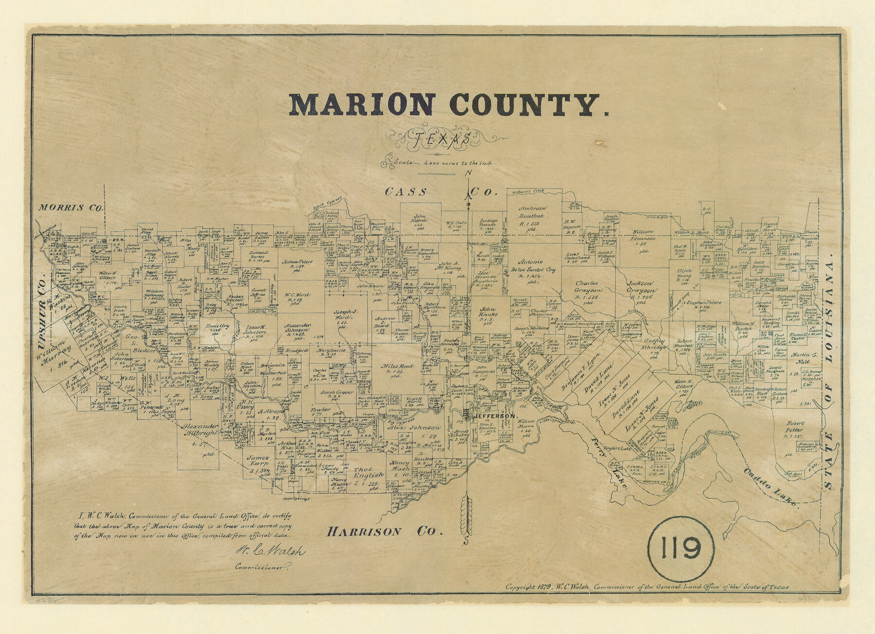
Marion County, Texas
-
Map/Doc
651
-
Collection
Maddox Collection
-
Object Dates
1879 (Creation Date)
1879 (Copyright Date)
-
People and Organizations
General Land Office (Publisher)
W.C. Walsh (GLO Commissioner)
-
Counties
Marion
-
Subjects
County
-
Height x Width
15.0 x 20.7 inches
38.1 x 52.6 cm
-
Medium
paper, etching/engraving/lithograph
-
Scale
1:4000
-
Comments
Conservation funded in 2008 by Friends of the Texas General Land Office.
-
Features
Black Cypress [Creek]
Wilburn's Creek
Jims Bayou
Fraziet's Bayou
Kitchen's Creek
Scott's Creek
Johnsons Creek
Alley's Creek
Harison Creek
Big Cypress [Creek]
Jefferson
Little Cypress [Creek]
Taylors Lake
Caddo Lake
Ferry Lake
Part of: Maddox Collection
Red River County, Texas

Print $20.00
- Digital $50.00
Red River County, Texas
1879
Size 29.3 x 21.9 inches
Map/Doc 598
[Sketch of Surveys in] Tom Green County, [Texas]
![471, [Sketch of Surveys in] Tom Green County, [Texas]](https://historictexasmaps.com/wmedia_w700/maps/0471.tif.jpg)
Print $20.00
- Digital $50.00
[Sketch of Surveys in] Tom Green County, [Texas]
1882
Size 14.1 x 20.3 inches
Map/Doc 471
[Unknown Building Sketch]
![75794, [Unknown Building Sketch], Maddox Collection](https://historictexasmaps.com/wmedia_w700/maps/75794.tif.jpg)
Print $20.00
- Digital $50.00
[Unknown Building Sketch]
Size 17.1 x 22.6 inches
Map/Doc 75794
McMullen County, Texas

Print $20.00
- Digital $50.00
McMullen County, Texas
1889
Size 28.7 x 22.1 inches
Map/Doc 575
Hidalgo County Sketch

Print $20.00
- Digital $50.00
Hidalgo County Sketch
1903
Size 30.4 x 37.7 inches
Map/Doc 4450
Map of survey made for Ingham S. Roberts on Application No. 147, SF-9177 containing 413.78 acres, 4 mi SE of Houston, Harris Co. Texas

Print $20.00
- Digital $50.00
Map of survey made for Ingham S. Roberts on Application No. 147, SF-9177 containing 413.78 acres, 4 mi SE of Houston, Harris Co. Texas
1910
Size 37.3 x 31.0 inches
Map/Doc 373
S.B. Burnett's King County Ranch

Print $20.00
- Digital $50.00
S.B. Burnett's King County Ranch
1902
Size 32.3 x 30.6 inches
Map/Doc 4441
[Pecos County Sketch]
![444, [Pecos County Sketch], Maddox Collection](https://historictexasmaps.com/wmedia_w700/maps/444.tif.jpg)
Print $20.00
- Digital $50.00
[Pecos County Sketch]
1880
Size 38.5 x 31.3 inches
Map/Doc 444
Map of Atascosa County, Texas

Print $20.00
- Digital $50.00
Map of Atascosa County, Texas
1879
Size 23.7 x 29.0 inches
Map/Doc 688
Western portion of the Ward Ranch, Cottle, Foard & Hardeman Counties, Swearingen, Texas sold to Luther T. Clark

Print $20.00
- Digital $50.00
Western portion of the Ward Ranch, Cottle, Foard & Hardeman Counties, Swearingen, Texas sold to Luther T. Clark
1916
Size 30.4 x 30.7 inches
Map/Doc 4460
[Office Sketch Showing George Tenille Grant, Brazoria County, Texas]
![75831, [Office Sketch Showing George Tenille Grant, Brazoria County, Texas], Maddox Collection](https://historictexasmaps.com/wmedia_w700/maps/75831.tif.jpg)
Print $20.00
- Digital $50.00
[Office Sketch Showing George Tenille Grant, Brazoria County, Texas]
Size 38.1 x 28.7 inches
Map/Doc 75831
McClennan [sic] County, Texas
![577, McClennan [sic] County, Texas, Maddox Collection](https://historictexasmaps.com/wmedia_w700/maps/577.tif.jpg)
Print $20.00
- Digital $50.00
McClennan [sic] County, Texas
1880
Size 23.5 x 26.7 inches
Map/Doc 577
You may also like
Gaines County Rolled Sketch 14A

Print $40.00
- Digital $50.00
Gaines County Rolled Sketch 14A
1940
Size 24.8 x 129.0 inches
Map/Doc 9031
Aransas County Aerial Photograph Index Sheet 1

Print $20.00
- Digital $50.00
Aransas County Aerial Photograph Index Sheet 1
1957
Size 22.9 x 18.2 inches
Map/Doc 83659
Flight Mission No. DCL-7C, Frame 121, Kenedy County

Print $20.00
- Digital $50.00
Flight Mission No. DCL-7C, Frame 121, Kenedy County
1943
Size 18.5 x 22.3 inches
Map/Doc 86086
Flight Mission No. DAG-26K, Frame 82, Matagorda County

Print $20.00
- Digital $50.00
Flight Mission No. DAG-26K, Frame 82, Matagorda County
1953
Size 18.4 x 19.1 inches
Map/Doc 86587
West Part of Anderson County

Print $20.00
- Digital $50.00
West Part of Anderson County
1942
Size 41.8 x 34.3 inches
Map/Doc 77197
[Blocks T1, T2, T3, S3, A, O5, and Capitol Leagues in Northwest Lamb County and Southwest Castro County]
![91005, [Blocks T1, T2, T3, S3, A, O5, and Capitol Leagues in Northwest Lamb County and Southwest Castro County], Twichell Survey Records](https://historictexasmaps.com/wmedia_w700/maps/91005-1.tif.jpg)
Print $20.00
- Digital $50.00
[Blocks T1, T2, T3, S3, A, O5, and Capitol Leagues in Northwest Lamb County and Southwest Castro County]
Size 30.3 x 34.0 inches
Map/Doc 91005
[Adams Beaty & Moulton Block 2] / Map of Heller's Addition to Canyon City
![92120, [Adams Beaty & Moulton Block 2] / Map of Heller's Addition to Canyon City, Twichell Survey Records](https://historictexasmaps.com/wmedia_w700/maps/92120-1.tif.jpg)
Print $20.00
- Digital $50.00
[Adams Beaty & Moulton Block 2] / Map of Heller's Addition to Canyon City
1898
Size 22.7 x 24.9 inches
Map/Doc 92120
Flight Mission No. CGI-1N, Frame 166, Cameron County

Print $20.00
- Digital $50.00
Flight Mission No. CGI-1N, Frame 166, Cameron County
1955
Size 18.5 x 22.2 inches
Map/Doc 84501
Current Miscellaneous File 37

Print $4.00
- Digital $50.00
Current Miscellaneous File 37
Size 13.2 x 8.7 inches
Map/Doc 73956
Jim Wells Co.

Print $20.00
- Digital $50.00
Jim Wells Co.
1966
Size 43.8 x 32.4 inches
Map/Doc 95548
Austin Old and New, a Mapguide to the Heart of the City including Capitol Complex & Government Buildings, Downtown Streets and Buildings, the University of Texas, Historical Sites, Parks & Trails, Sixth Street, Town Lake, Museums

Austin Old and New, a Mapguide to the Heart of the City including Capitol Complex & Government Buildings, Downtown Streets and Buildings, the University of Texas, Historical Sites, Parks & Trails, Sixth Street, Town Lake, Museums
Size 25.4 x 31.2 inches
Map/Doc 94380
Flight Mission No. DQO-3K, Frame 82, Galveston County

Print $20.00
- Digital $50.00
Flight Mission No. DQO-3K, Frame 82, Galveston County
1952
Size 18.7 x 22.5 inches
Map/Doc 85087