![92120, [Adams Beaty & Moulton Block 2] / Map of Heller's Addition to Canyon City, Twichell Survey Records](https://historictexasmaps.com/wmedia_w1800h1800/maps/92120-1.tif.jpg)
[Adams Beaty & Moulton Block 2] / Map of Heller's Addition to Canyon City
-
Map/Doc
92120
-
Collection
Twichell Survey Records
-
Object Dates
1898 (Creation Date)
-
Counties
Randall
-
Height x Width
22.7 x 24.9 inches
57.7 x 63.3 cm
Part of: Twichell Survey Records
[North line of Hansford, Ochiltree and Lipscomb Counties]
![93190, [North line of Hansford, Ochiltree and Lipscomb Counties], Twichell Survey Records](https://historictexasmaps.com/wmedia_w700/maps/93190-1.tif.jpg)
Print $40.00
- Digital $50.00
[North line of Hansford, Ochiltree and Lipscomb Counties]
Size 89.3 x 16.8 inches
Map/Doc 93190
Working Sketch Dickens and Kent Counties

Print $20.00
- Digital $50.00
Working Sketch Dickens and Kent Counties
1904
Size 16.3 x 20.7 inches
Map/Doc 90862
[M. B. & B. Blks. A, B & C near Coyote Lake]
![90249, [M. B. & B. Blks. A, B & C near Coyote Lake], Twichell Survey Records](https://historictexasmaps.com/wmedia_w700/maps/90249-1.tif.jpg)
Print $20.00
- Digital $50.00
[M. B. & B. Blks. A, B & C near Coyote Lake]
Size 15.4 x 23.3 inches
Map/Doc 90249
Survey Map of Runnels County

Print $20.00
- Digital $50.00
Survey Map of Runnels County
Size 33.6 x 40.3 inches
Map/Doc 92918
Wilda Stewart Farm, Crosby County, Texas

Print $20.00
- Digital $50.00
Wilda Stewart Farm, Crosby County, Texas
1949
Size 20.5 x 20.4 inches
Map/Doc 92599
Cow Bayou Oil Field, Orange County, Texas

Print $20.00
- Digital $50.00
Cow Bayou Oil Field, Orange County, Texas
Size 24.0 x 18.8 inches
Map/Doc 93016
Blocks 2, 8, and 9. Capitol Syndicate Subdivision of Capitol Leagues or Portions of Capitol Leagues 59, 60, 61, 62, 63, 64, 65, 66, 69, 70, 71, 72, 73, 74, 75, 76, 83, 84, 85, 86, 87, 88, 89, 90, 91, 92, 108, 109, and 110. Dallam County, Texas

Print $20.00
- Digital $50.00
Blocks 2, 8, and 9. Capitol Syndicate Subdivision of Capitol Leagues or Portions of Capitol Leagues 59, 60, 61, 62, 63, 64, 65, 66, 69, 70, 71, 72, 73, 74, 75, 76, 83, 84, 85, 86, 87, 88, 89, 90, 91, 92, 108, 109, and 110. Dallam County, Texas
1906
Size 31.7 x 28.3 inches
Map/Doc 92581
[Section 70, Block 8, Dawson and Lynn Counties, Texas]
![92562, [Section 70, Block 8, Dawson and Lynn Counties, Texas], Twichell Survey Records](https://historictexasmaps.com/wmedia_w700/maps/92562-1.tif.jpg)
Print $20.00
- Digital $50.00
[Section 70, Block 8, Dawson and Lynn Counties, Texas]
Size 23.9 x 19.6 inches
Map/Doc 92562
[Survey 1, Block MT, and vicinity]
![90683, [Survey 1, Block MT, and vicinity], Twichell Survey Records](https://historictexasmaps.com/wmedia_w700/maps/90683-1.tif.jpg)
Print $3.00
- Digital $50.00
[Survey 1, Block MT, and vicinity]
1903
Size 11.1 x 14.6 inches
Map/Doc 90683
[Sections 94 and 826-831 along Red River]
![93161, [Sections 94 and 826-831 along Red River], Twichell Survey Records](https://historictexasmaps.com/wmedia_w700/maps/93161-1.tif.jpg)
Print $40.00
- Digital $50.00
[Sections 94 and 826-831 along Red River]
Size 43.2 x 111.4 inches
Map/Doc 93161
[Portion of Terry & Lynn County Lines]
![92906, [Portion of Terry & Lynn County Lines], Twichell Survey Records](https://historictexasmaps.com/wmedia_w700/maps/92906-1.tif.jpg)
Print $20.00
- Digital $50.00
[Portion of Terry & Lynn County Lines]
Size 22.6 x 14.0 inches
Map/Doc 92906
[Sections 55-58, Blk. GG and surrounding surveys]
![90319, [Sections 55-58, Blk. GG and surrounding surveys], Twichell Survey Records](https://historictexasmaps.com/wmedia_w700/maps/90319-1.tif.jpg)
Print $20.00
- Digital $50.00
[Sections 55-58, Blk. GG and surrounding surveys]
Size 41.1 x 29.7 inches
Map/Doc 90319
You may also like
Erath County Working Sketch 50a

Print $20.00
- Digital $50.00
Erath County Working Sketch 50a
Size 43.2 x 37.0 inches
Map/Doc 69131
Reeves County Rolled Sketch 10

Print $20.00
- Digital $50.00
Reeves County Rolled Sketch 10
Size 22.4 x 42.0 inches
Map/Doc 7480
Northeast Part of Crockett County

Print $20.00
- Digital $50.00
Northeast Part of Crockett County
1976
Size 35.6 x 47.0 inches
Map/Doc 95469
Upton County Sketch File 42

Print $3.00
- Digital $50.00
Upton County Sketch File 42
1986
Size 10.9 x 17.0 inches
Map/Doc 38919
Map from Corpus Christi to Matagorda Bays, Texas [Inset: Survey of the channel of Copono Bay]
![72973, Map from Corpus Christi to Matagorda Bays, Texas [Inset: Survey of the channel of Copono Bay], General Map Collection](https://historictexasmaps.com/wmedia_w700/maps/72973.tif.jpg)
Print $20.00
- Digital $50.00
Map from Corpus Christi to Matagorda Bays, Texas [Inset: Survey of the channel of Copono Bay]
1846
Size 18.2 x 27.5 inches
Map/Doc 72973

Bastrop County

Print $40.00
- Digital $50.00
Bastrop County
1917
Size 49.7 x 42.0 inches
Map/Doc 4796
Hudspeth County Working Sketch 33

Print $20.00
- Digital $50.00
Hudspeth County Working Sketch 33
1977
Size 26.8 x 21.4 inches
Map/Doc 66318
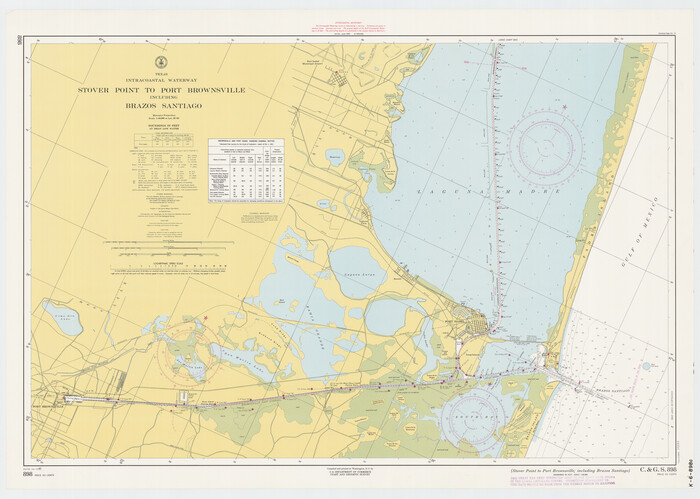
Texas Intracoastal Waterway - Stover Point to Port Brownsville including Brazos Santiago
Print $20.00
- Digital $50.00
Texas Intracoastal Waterway - Stover Point to Port Brownsville including Brazos Santiago
1962
Size 27.8 x 38.9 inches
Map/Doc 73520
Rhyne Simpson Addition No. 2, City of Lubbock Section 3, Block O

Print $20.00
- Digital $50.00
Rhyne Simpson Addition No. 2, City of Lubbock Section 3, Block O
1951
Size 12.2 x 18.4 inches
Map/Doc 92731
Map of Corpus Christi Bay in Nueces County Showing Subdivision Thereof for Mineral Development

Print $20.00
- Digital $50.00
Map of Corpus Christi Bay in Nueces County Showing Subdivision Thereof for Mineral Development
1940
Size 23.3 x 34.7 inches
Map/Doc 2941
[Sketch for Mineral Application 26501 - Sabine River, T. A. Oldhausen]
![2847, [Sketch for Mineral Application 26501 - Sabine River, T. A. Oldhausen], General Map Collection](https://historictexasmaps.com/wmedia_w700/maps/2847.tif.jpg)
Print $20.00
- Digital $50.00
[Sketch for Mineral Application 26501 - Sabine River, T. A. Oldhausen]
1931
Size 24.7 x 37.1 inches
Map/Doc 2847