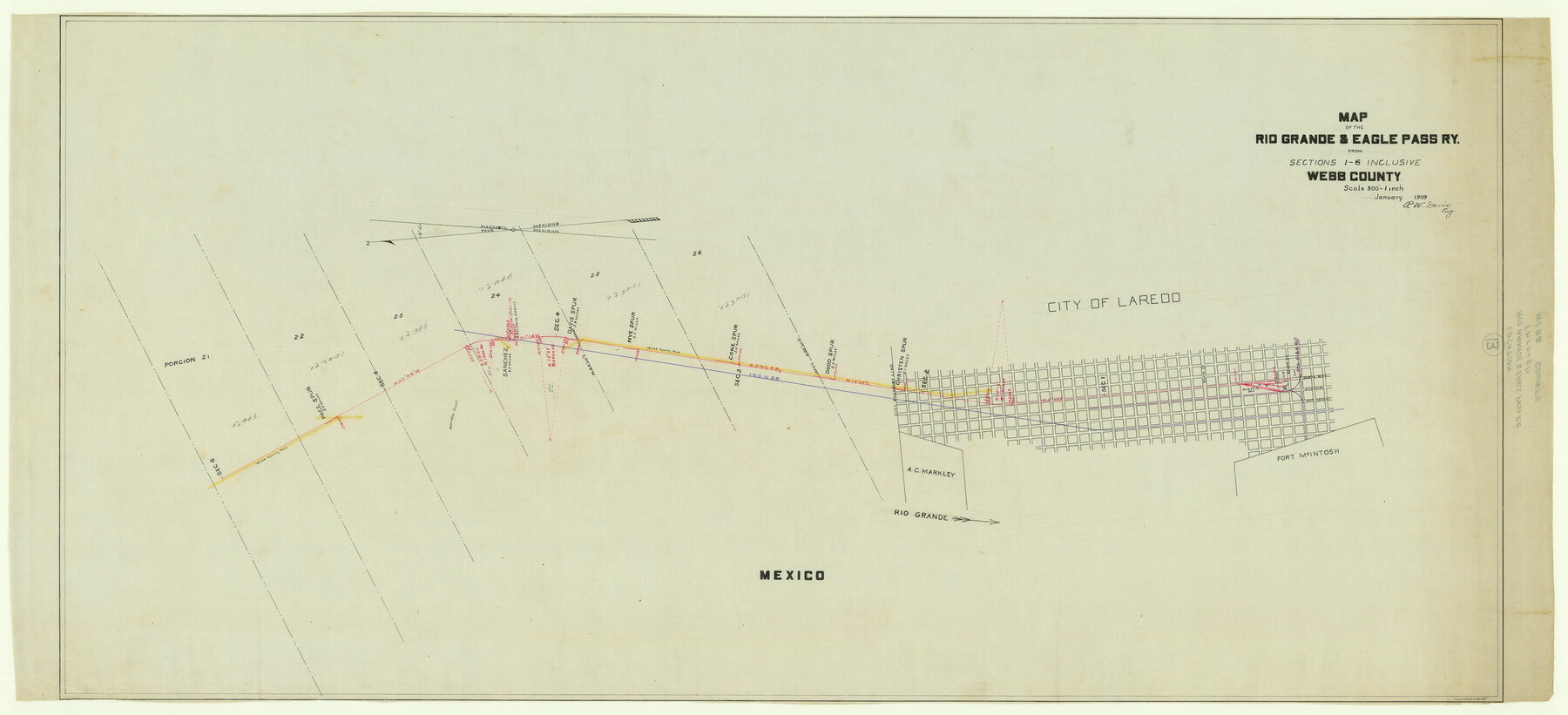
Map of the Rio Grande & Eagle Pass Ry. from Sections 1-6 Inclusive, Webb County
Z-2-13
-
Map/Doc
64655
-
Collection
General Map Collection
-
Object Dates
1909 (Creation Date)
-
People and Organizations
R. W. Davis (Surveyor/Engineer)
-
Counties
Webb
-
Subjects
Railroads
-
Height x Width
25.4 x 55.7 inches
64.5 x 141.5 cm
-
Medium
linen, manuscript
-
Scale
1" = 800 feet
-
Comments
From Sections 1 through 6.
See counter nos. 64656 through 64658 for other sections of the map. -
Features
RG&EP
Fort McIntosh
Laredo
I&GN
Dodd Spur
Cone Spur
Nye Spur
Davis Spur
Manadas Creek
Webb County Road
Pace Spur
Rio Grande
Part of: General Map Collection
McLennan County Working Sketch 9

Print $20.00
- Digital $50.00
McLennan County Working Sketch 9
2008
Size 23.0 x 28.9 inches
Map/Doc 88768
Flight Mission No. CRK-3P, Frame 129, Refugio County

Print $20.00
- Digital $50.00
Flight Mission No. CRK-3P, Frame 129, Refugio County
1956
Size 18.5 x 22.4 inches
Map/Doc 86917
Bosque County Sketch File 29

Print $6.00
- Digital $50.00
Bosque County Sketch File 29
1863
Size 12.9 x 8.1 inches
Map/Doc 14816
Wharton County Rolled Sketch 5

Print $20.00
- Digital $50.00
Wharton County Rolled Sketch 5
1899
Size 19.3 x 24.6 inches
Map/Doc 8229
Camp County Sketch File 1

Print $4.00
- Digital $50.00
Camp County Sketch File 1
Size 10.4 x 8.1 inches
Map/Doc 17333
Brown County Working Sketch 7

Print $20.00
- Digital $50.00
Brown County Working Sketch 7
1954
Size 26.5 x 28.7 inches
Map/Doc 67772
Brewster County Working Sketch 65

Print $20.00
- Digital $50.00
Brewster County Working Sketch 65
1958
Size 40.2 x 34.8 inches
Map/Doc 67666
Childress County Boundary File 3a

Print $80.00
- Digital $50.00
Childress County Boundary File 3a
Size 30.7 x 70.1 inches
Map/Doc 51354
Flight Mission No. DCL-5C, Frame 71, Kenedy County

Print $20.00
- Digital $50.00
Flight Mission No. DCL-5C, Frame 71, Kenedy County
1943
Size 18.5 x 22.2 inches
Map/Doc 85854
Angelina County Working Sketch 43

Print $20.00
- Digital $50.00
Angelina County Working Sketch 43
1963
Size 23.1 x 34.5 inches
Map/Doc 67126
Right of Way and Track Map, the Missouri, Kansas and Texas Ry. of Texas - Henrietta Division

Print $20.00
- Digital $50.00
Right of Way and Track Map, the Missouri, Kansas and Texas Ry. of Texas - Henrietta Division
1918
Size 11.7 x 26.8 inches
Map/Doc 64756
Houston Ship Channel, Alexander Island to Carpenter Bayou

Print $40.00
- Digital $50.00
Houston Ship Channel, Alexander Island to Carpenter Bayou
1982
Size 36.0 x 49.5 inches
Map/Doc 69913
You may also like
Presidio County Sketch File 46

Print $8.00
- Digital $50.00
Presidio County Sketch File 46
1915
Size 10.2 x 8.3 inches
Map/Doc 34535
Coast Chart No. 210 - Aransas Pass and Corpus Christi Bay with the coast to latitude 27° 12', Texas

Print $20.00
- Digital $50.00
Coast Chart No. 210 - Aransas Pass and Corpus Christi Bay with the coast to latitude 27° 12', Texas
1907
Size 18.4 x 24.2 inches
Map/Doc 73450
Culberson County Working Sketch 39

Print $40.00
- Digital $50.00
Culberson County Working Sketch 39
1966
Size 37.9 x 82.7 inches
Map/Doc 68492
Map of Nueces County

Print $20.00
- Digital $50.00
Map of Nueces County
1875
Size 24.6 x 37.4 inches
Map/Doc 3919
General Highway Map, Kaufman County, Texas

Print $20.00
General Highway Map, Kaufman County, Texas
1961
Size 24.9 x 18.1 inches
Map/Doc 79548
Concho County Sketch File 40

Print $26.00
- Digital $50.00
Concho County Sketch File 40
1949
Size 11.3 x 8.7 inches
Map/Doc 19194
Portion of States Submerged Area in Matagorda Bay

Print $20.00
- Digital $50.00
Portion of States Submerged Area in Matagorda Bay
1921
Size 15.7 x 15.1 inches
Map/Doc 2950
Flight Mission No. DQO-8K, Frame 75, Galveston County

Print $20.00
- Digital $50.00
Flight Mission No. DQO-8K, Frame 75, Galveston County
1952
Size 18.7 x 22.5 inches
Map/Doc 85179
Sutton County Sketch File 3

Print $8.00
- Digital $50.00
Sutton County Sketch File 3
Size 12.9 x 8.5 inches
Map/Doc 37353
Flight Mission No. DQN-2K, Frame 138, Calhoun County

Print $20.00
- Digital $50.00
Flight Mission No. DQN-2K, Frame 138, Calhoun County
1953
Size 16.1 x 16.0 inches
Map/Doc 84307
Sutton County Sketch File JAC (1)

Print $6.00
- Digital $50.00
Sutton County Sketch File JAC (1)
1937
Size 14.3 x 8.8 inches
Map/Doc 37502
The Mexican Department of Brazos. Created, March 18, 1834

Print $20.00
The Mexican Department of Brazos. Created, March 18, 1834
2020
Size 19.7 x 21.7 inches
Map/Doc 95975