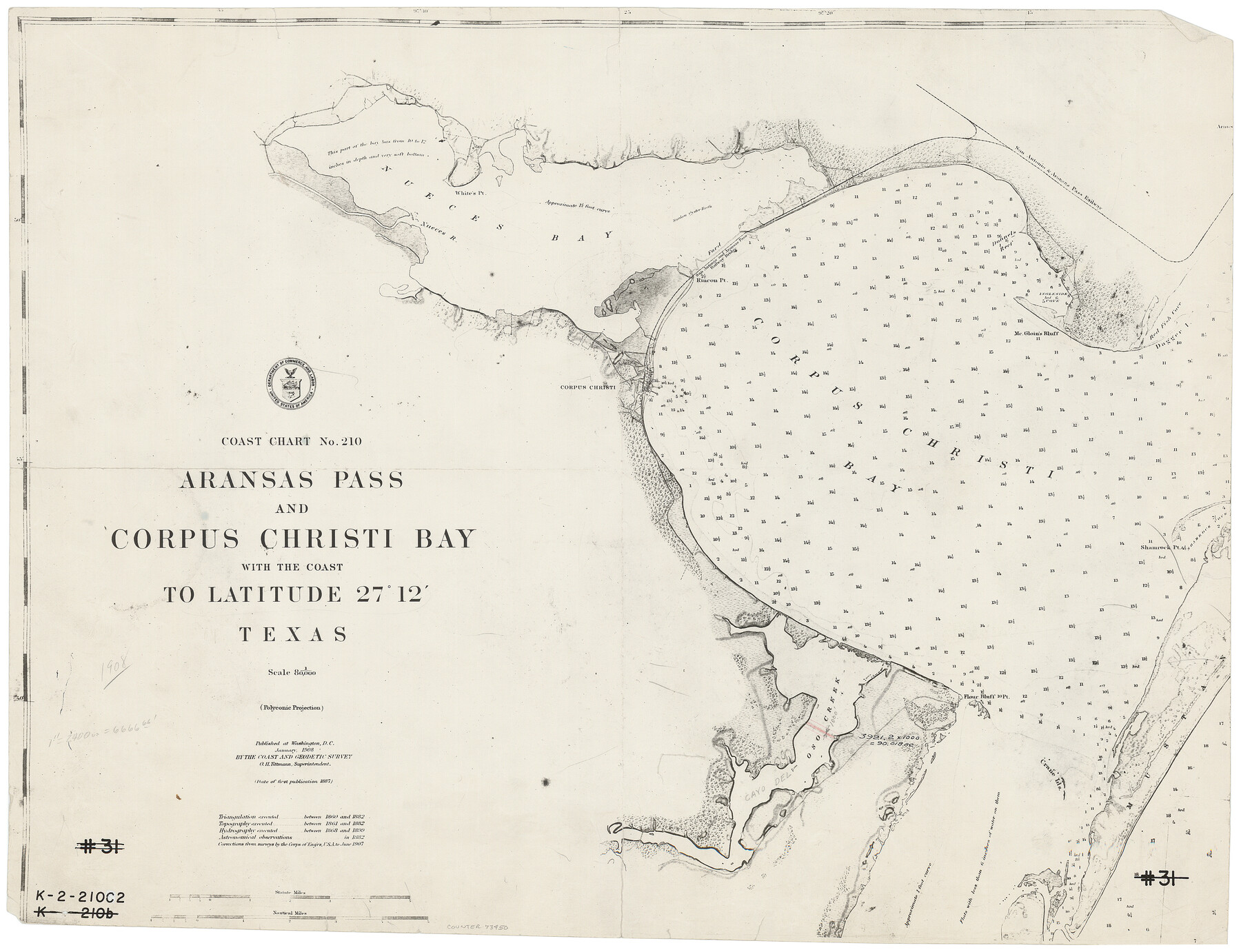
Coast Chart No. 210 - Aransas Pass and Corpus Christi Bay with the coast to latitude 27° 12', Texas
K-2-210a1
-
Map/Doc
73450
-
Collection
General Map Collection
-
Object Dates
1907 (Creation Date)
-
Counties
Aransas San Patricio Nueces Kleberg
-
Subjects
Nautical Charts
-
Height x Width
18.4 x 24.2 inches
46.7 x 61.5 cm
Part of: General Map Collection
Flight Mission No. CUG-3P, Frame 131, Kleberg County

Print $20.00
- Digital $50.00
Flight Mission No. CUG-3P, Frame 131, Kleberg County
1956
Size 18.7 x 22.4 inches
Map/Doc 86266
Childress County Working Sketch Graphic Index

Print $20.00
- Digital $50.00
Childress County Working Sketch Graphic Index
1978
Size 45.5 x 34.3 inches
Map/Doc 76493
Johnson County Working Sketch 3

Print $20.00
- Digital $50.00
Johnson County Working Sketch 3
1948
Size 29.1 x 24.2 inches
Map/Doc 66616
Leon County Working Sketch 8

Print $20.00
- Digital $50.00
Leon County Working Sketch 8
1931
Size 28.9 x 42.8 inches
Map/Doc 70407

Val Verde County Rolled Sketch 51

Print $40.00
- Digital $50.00
Val Verde County Rolled Sketch 51
1937
Size 29.4 x 48.4 inches
Map/Doc 10075
Brewster County Working Sketch 59

Print $20.00
- Digital $50.00
Brewster County Working Sketch 59
1955
Size 24.6 x 19.0 inches
Map/Doc 67660
Runnels County Sketch File 24

Print $20.00
Runnels County Sketch File 24
1930
Size 25.2 x 21.3 inches
Map/Doc 12258
South Sulphur River, Klondike Sheet

Print $20.00
- Digital $50.00
South Sulphur River, Klondike Sheet
1925
Size 18.2 x 19.9 inches
Map/Doc 78332
Dickens County Sketch File GW1

Print $20.00
- Digital $50.00
Dickens County Sketch File GW1
1911
Size 31.5 x 24.4 inches
Map/Doc 11334

Terry County Sketch File 15

Print $10.00
- Digital $50.00
Terry County Sketch File 15
1944
Size 11.3 x 8.9 inches
Map/Doc 38034
You may also like
Sutton County Working Sketch 47

Print $20.00
- Digital $50.00
Sutton County Working Sketch 47
1954
Size 34.3 x 21.3 inches
Map/Doc 62390
Section across Valley Bench and Terraces - South Side of Red River - Big Bend Area

Print $20.00
Section across Valley Bench and Terraces - South Side of Red River - Big Bend Area
1921
Size 10.2 x 34.8 inches
Map/Doc 79750
Lamar County Working Sketch 3

Print $20.00
- Digital $50.00
Lamar County Working Sketch 3
1919
Size 26.2 x 24.5 inches
Map/Doc 70264
Flight Mission No. CGI-2N, Frame 184, Cameron County

Print $20.00
- Digital $50.00
Flight Mission No. CGI-2N, Frame 184, Cameron County
1954
Size 18.5 x 22.1 inches
Map/Doc 84544
Flight Mission No. DQN-1K, Frame 109, Calhoun County

Print $20.00
- Digital $50.00
Flight Mission No. DQN-1K, Frame 109, Calhoun County
1953
Size 18.4 x 22.1 inches
Map/Doc 84176
Galveston County Sketch File 47

Print $14.00
- Digital $50.00
Galveston County Sketch File 47
1976
Size 11.3 x 8.9 inches
Map/Doc 23454
Marion County Sketch File 7

Print $40.00
- Digital $50.00
Marion County Sketch File 7
1866
Size 16.2 x 12.0 inches
Map/Doc 30573
Bell County Working Sketch 20

Print $20.00
- Digital $50.00
Bell County Working Sketch 20
1996
Size 39.5 x 34.7 inches
Map/Doc 67360
Scurry County Sketch File 2

Print $4.00
- Digital $50.00
Scurry County Sketch File 2
1888
Size 13.2 x 7.4 inches
Map/Doc 36563
Zavala County Sketch File 45

Print $4.00
- Digital $50.00
Zavala County Sketch File 45
1923
Size 11.5 x 8.8 inches
Map/Doc 41428
Flight Mission No. DAG-21K, Frame 129, Matagorda County

Print $20.00
- Digital $50.00
Flight Mission No. DAG-21K, Frame 129, Matagorda County
1952
Size 18.6 x 22.5 inches
Map/Doc 86455
Fractional Township No. 9 South Range No. 9 East of the Indian Meridian, Indian Territory

Print $20.00
- Digital $50.00
Fractional Township No. 9 South Range No. 9 East of the Indian Meridian, Indian Territory
1898
Size 19.2 x 24.4 inches
Map/Doc 75216